FAA INFORMATION EFFECTIVE 14 MAY 2026
Location
| FAA Identifier: | ERY |
| Lat/Long: | 46-18-39.6000N 085-27-25.8000W
46-18.660000N 085-27.430000W
46.3110000,-85.4571667
(estimated) |
| Elevation: | 869.2 ft. / 265 m (estimated) |
| Variation: | 06W (1995) |
| From city: | 3 miles SE of NEWBERRY, MI |
| Time zone: | UTC -4 (UTC -5 during Standard Time) |
| Zip code: | 49868 |
Airport Operations
| Airport use: | Open to the public |
| Activation date: | 04/1940 |
| Control tower: | no |
| ARTCC: | MINNEAPOLIS CENTER |
| FSS: | GREEN BAY FLIGHT SERVICE STATION |
| NOTAMs facility: | ERY (NOTAM-D service available) |
| Attendance: | MON-FRI 0800-1600, ALL SAT-SUN ON CALL
WKENDS O/R. |
| Wind indicator: | lighted |
| Segmented circle: | yes |
| Lights: | ACTVT WIND CONE; REIL RWY 11 & 29; PAPI RWY 11 & 29; MIRL RWY 11/29 - CTAF. |
| Beacon: | white-green (lighted land airport)
Operates sunset to sunrise. |
Airport Communications
| CTAF/UNICOM: | 122.8 |
| WX AWOS-3P: | 119.525 (906-293-2979) |
- COMMUNICATIONS PRVDD BY GREEN BAY RADIO ON FREQ 122.4 (NEWBERRY RCO).
- APCH/DEP SVC PRVDD BY MINNEAPOLIS ARTCC (ZMP) ON FREQ 134.6/354.05 (PELLSTON RCAG).
Airport Services
| Fuel available: | 100LL JET-A+ |
| Parking: | hangars and tiedowns |
| Airframe service: | NONE |
| Powerplant service: | NONE |
| Bottled oxygen: | NONE |
| Bulk oxygen: | NONE |
Runway Information
Runway 11/29
| Dimensions: | 4304 x 75 ft. / 1312 x 23 m |
| Surface: | asphalt, in good condition |
| Weight bearing capacity: | |
| Runway edge lights: | medium intensity |
| RUNWAY 11 | | RUNWAY 29 |
| Latitude: | 46-18.943338N | | 46-18.698353N |
| Longitude: | 085-28.069635W | | 085-27.110833W |
| Elevation: | 869.1 ft. | | 851.2 ft. |
| Traffic pattern: | left | | left |
| Runway heading: | 116 magnetic, 110 true | | 296 magnetic, 290 true |
| Markings: | nonprecision, in good condition | | nonprecision, in good condition |
| Visual slope indicator: | 4-light PAPI on left (3.20 degrees glide path) | | 4-light PAPI on left (3.20 degrees glide path) |
| Runway end identifier lights: | yes | | yes |
| Touchdown point: | yes, no lights | | yes, no lights |
Runway 4/22
| Dimensions: | 2856 x 150 ft. / 871 x 46 m |
| Surface: | turf, in good condition |
| Runway edge markings: | 3 FT YELLOW CONES. |
| Operational restrictions: | CLSD WHEN SNOW COVD EXC FOR SKI EQUIPPED ACFT. |
| RUNWAY 4 | | RUNWAY 22 |
| Latitude: | 46-18.240943N | | 46-18.595083N |
| Longitude: | 085-27.411513W | | 085-26.965815W |
| Elevation: | 853.3 ft. | | 850.4 ft. |
| Traffic pattern: | left | | left |
| Runway heading: | 047 magnetic, 041 true | | 227 magnetic, 221 true |
| Displaced threshold: | 936 ft.
APCH RATIO 19:1 TO DTHR OVR +82 FT TREES, 1600 FT DIST, 120L. | | no |
| Touchdown point: | yes, no lights | | yes, no lights |
| Obstructions: | 10 ft. fence, 125 ft. right of centerline
CTLNG OBSTN EXCEEDS A 45 DEG SLP. | | 24 ft. trees, 261 ft. from runway, 116 ft. left of centerline, 10:1 slope to clear |
Airport Ownership and Management from official FAA records
| Ownership: | Publicly-owned |
| Owner: | LUCE COUNTY
LUCE CO GOVT BLDG, 407 W HARRIE ST
NEWBERRY, MI 49868-1208
Phone 906-293-5521 |
| Manager: | GLEN PITTMAN
5523 COUNTY ROAD 399
NEWBERRY, MI 49868-7882
Phone 906-291-0214
CELL. |
Additional Remarks
| - | DEER, BIRDS, & WILDLIFE ON & INVOF ARPT. |
| - | FOR CD IF UNA TO CTC ON FSS FREQ, CTC MINNEAPOLIS ARTCC AT 651-463-5588. |
Instrument Procedures
NOTE: All procedures below are presented as PDF files. If you need a reader for these files, you should download the free Adobe Reader.NOT FOR NAVIGATION. Please procure official charts for flight.
FAA instrument procedures published for use from 14 May 2026 at 0901Z to 11 June 2026 at 0900Z.
IAPs - Instrument Approach Procedures |
|---|
| RNAV (GPS) RWY 11 | |
download (215KB) |
| RNAV (GPS) RWY 29 | |
download (250KB) |
| NOTE: Special Alternate Minimums apply | |
download (135KB) |
| NOTE: Special Take-Off Minimums/Departure Procedures apply | |
download (122KB) |
Other nearby airports with instrument procedures:
KISQ - Schoolcraft County Airport (36 nm SW)
KSJX - Beaver Island Airport (37 nm S)
83D - Mackinac County Airport (39 nm SE)
KCIU - Chippewa County International Airport (41 nm E)
KMCD - Mackinac Island Airport (43 nm SE)
|
|

Road maps at:
MapQuest
Bing
Google
| Aerial photo |
|---|
WARNING: Photo may not be current or correct

Do you have a better or more recent aerial photo of Luce County Airport that you would like to share? If so, please send us your photo.
|
| Sectional chart |
|---|
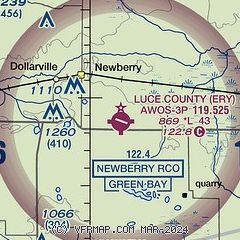
|
| Airport distance calculator |
|---|
|
|
| Sunrise and sunset |
|---|
|
Times for 23-May-2026
| | Local
(UTC-4) | | Zulu
(UTC) |
|---|
| Morning civil twilight | | 05:25 | | 09:25 |
| Sunrise | | 06:01 | | 10:01 |
| Sunset | | 21:16 | | 01:16 |
| Evening civil twilight | | 21:53 | | 01:53 |
|
| Current date and time |
|---|
| Zulu (UTC) | 23-May-2026 16:39:08 |
|---|
| Local (UTC-4) | 23-May-2026 12:39:08 |
|---|
|
| METAR |
|---|
| KERY | 231555Z AUTO 12013G21KT 10SM BKN035 OVC046 15/03 A3012 RMK AO2
|
|
| TAF |
|---|
CYAM
41nm E | 231340Z 2314/2402 11012G22KT P6SM BKN040 OVC080 TEMPO 2316/2318 P6SM -SHRA FM232000 10015G25KT P6SM OVC030 TEMPO 2320/2402 5SM -SHRA BR OVC020 BECMG 2322/2324 10010KT RMK NXT FCST BY 232000Z
|
KCIU
41nm E | 231120Z 2312/2412 11012G23KT P6SM BKN120 FM231700 12017G28KT P6SM BKN050 FM232100 12016G27KT P6SM BKN020 FM240100 12013G22KT P6SM OVC009 FM240600 11008KT P6SM OVC005
|
|
| NOTAMs |
|---|
NOTAMs are issued by the DoD/FAA and will open in a separate window not controlled by AirNav.
|
|

