FAA INFORMATION EFFECTIVE 14 MAY 2026
Location
| FAA Identifier: | JCA |
| Lat/Long: | 34-10-34.1000N 083-33-42.1000W
34-10.568333N 083-33.701667W
34.1761389,-83.5616944
(estimated) |
| Elevation: | 950.5 ft. / 289.7 m (surveyed) |
| Variation: | 05W (2010) |
| From city: | 3 miles NE of JEFFERSON, GA |
| Time zone: | UTC -4 (UTC -5 during Standard Time) |
| Zip code: | 30529 |
Airport Operations
| Airport use: | Open to the public |
| Activation date: | 11/1957 |
| Control tower: | no |
| ARTCC: | ATLANTA CENTER |
| FSS: | MACON FLIGHT SERVICE STATION |
| NOTAMs facility: | MCN (NOTAM-D service available) |
| Attendance: | MON-FRI 0800-1700 |
| Wind indicator: | lighted |
| Segmented circle: | yes |
| Lights: | MIRL RWY 17/35 PRESET ON MED INTST, TO INCR INTST AND ACTVT PAPI RWY 17 & 35 - CTAF. |
| Beacon: | white-green (lighted land airport)
Operates sunset to sunrise. |
Airport Communications
| CTAF/UNICOM: | 122.975 |
| WX AWOS-3PT: | 118.125 (706-387-6477) |
| ATLANTA APPROACH: | 132.475 ;0615-2200 |
| ATLANTA DEPARTURE: | 132.475 ;0615-2200 |
| WX AWOS-3 at WDR (13 nm SW): | 118.575 (770-868-0642) |
| WX ASOS at GVL (15 nm NW): | 126.475 (770-532-4687) |
| WX ASOS at AHN (18 nm SE): | 132.875 (706-363-3481) |
| WX AWOS-3 at AJR (19 nm N): | 119.175 (706-778-3675) |
- APCH/DEP SVC PRVDD BY ATLANTA TRACON 0615-2200 ON FREQS 132.475/291.1 OTHER TIMES BY ATLANTA ARTCC ON FREQS 127.5/316.05 (ATHENS RCAG).
Nearby radio navigation aids
| VOR radial/distance | | VOR name | | Freq | | Var |
|---|
| AHNr319/18.1 | | ATHENS VOR/DME | | 116.95 | | 00E |
| ODFr203/33.8 | | FOOTHILLS VOR/DME | | 113.40 | | 00E |
| NDB name | | Hdg/Dist | | Freq | | Var | | ID |
|---|
| BARROW COUNTY | | 010/14.5 | | 404 | | 05W | | BMW | -... -- .-- |
Airport Services
| Fuel available: | 100LL JET-A+ |
| Parking: | hangars and tiedowns |
| Airframe service: | MAJOR |
| Powerplant service: | MINOR |
| Bottled oxygen: | NONE |
| Bulk oxygen: | NONE |
Runway Information
Runway 17/35
| Dimensions: | 5010 x 75 ft. / 1527 x 23 m |
| Surface: | asphalt, in excellent condition |
| Weight bearing capacity: | | Single wheel: | 30.0 | | Double wheel: | 43.0 |
|
| Runway edge lights: | medium intensity |
| RUNWAY 17 | | RUNWAY 35 |
| Latitude: | 34-10.963483N | | 34-10.172013N |
| Longitude: | 083-33.843592W | | 083-33.559513W |
| Elevation: | 931.1 ft. | | 950.5 ft. |
| Traffic pattern: | left | | left |
| Runway heading: | 168 magnetic, 163 true | | 348 magnetic, 343 true |
| Markings: | nonprecision, in good condition | | nonprecision, in good condition |
| Visual slope indicator: | 2-light PAPI on left (3.00 degrees glide path) | | 2-light PAPI on left (3.00 degrees glide path) |
| Touchdown point: | yes, no lights | | yes, no lights |
| Obstructions: | 91 ft. trees, 1313 ft. from runway, 400 ft. right of centerline, 12:1 slope to clear | | 43 ft. trees, 837 ft. from runway, 294 ft. right of centerline, 14:1 slope to clear |
Airport Ownership and Management from official FAA records
| Ownership: | Publicly-owned |
| Owner: | JACKSON COUNTY, C/O COUNTY MGR.
4965 JACKSON PARKWAY
JEFFERSON, GA 30549
Phone 706-367-6314 |
| Manager: | TOM STRONG
1562 AIRPORT RD
JEFFERSON, GA 30549
Phone 706-367-1493 |
Additional Remarks
| - | DEER ON & INVOF ARPT. |
| - | FUEL 24 HR CREDIT CARD SVC AVBL. |
| - | FOR APCH/DEP SVC CTC ATLANTA APCH AT 678-364-6131. WHEN ATLANTA APCH UNAVBL CTC ATLANTA ARTCC AT 770-210-7692. |
Instrument Procedures
NOTE: All procedures below are presented as PDF files. If you need a reader for these files, you should download the free Adobe Reader.NOT FOR NAVIGATION. Please procure official charts for flight.
FAA instrument procedures published for use from 14 May 2026 at 0901Z to 11 June 2026 at 0900Z.
IAPs - Instrument Approach Procedures |
|---|
| RNAV (GPS) RWY 17 | |
download (244KB) |
| RNAV (GPS) RWY 35 | |
download (233KB) |
| VOR RWY 35 | |
download (204KB) |
| NOTE: Special Alternate Minimums apply | |
download (159KB) |
| NOTE: Special Take-Off Minimums/Departure Procedures apply | |
download (288KB) |
Other nearby airports with instrument procedures:
KWDR - Barrow County Airport (13 nm SW)
KGVL - Lee Gilmer Memorial Airport (15 nm NW)
KAHN - Athens/Ben Epps Airport (18 nm SE)
KAJR - Habersham County Airport (19 nm N)
KLZU - Gwinnett County Airport-Briscoe Field (23 nm SW)
|
|

Road maps at:
MapQuest
Bing
Google
| Aerial photo |
|---|
WARNING: Photo may not be current or correct
 Taken in 2009
looking north.
Taken in 2009
looking north.
Do you have a better or more recent aerial photo of Jackson County Airport that you would like to share? If so, please send us your photo.
|
| Sectional chart |
|---|
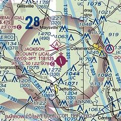
|
CAUTION: Diagram may not be current

| Airport distance calculator |
|---|
|
|
| Sunrise and sunset |
|---|
|
Times for 01-Jun-2026
| | Local
(UTC-4) | | Zulu
(UTC) |
|---|
| Morning civil twilight | | 05:56 | | 09:56 |
| Sunrise | | 06:25 | | 10:25 |
| Sunset | | 20:40 | | 00:40 |
| Evening civil twilight | | 21:08 | | 01:08 |
|
| Current date and time |
|---|
| Zulu (UTC) | 01-Jun-2026 11:40:43 |
|---|
| Local (UTC-4) | 01-Jun-2026 07:40:43 |
|---|
|
| METAR |
|---|
| KJCA | 011115Z AUTO 28003KT 3SM BR BKN005 OVC008 17/ A3002 RMK AO2 T0174////
|
KWDR
13nm SW | 011115Z 10SM OVC009 17/16 A3003 RMK AO2 LTG DSNT SE
|
KGVL
15nm W | 011116Z AUTO 2 1/2SM BR OVC004 18/17 A3003 RMK AO2 T01780172
|
KAHN
18nm SE | 011051Z AUTO 00000KT 8SM OVC009 18/17 A3000 RMK AO2 CIG 006V010 SLP156 T01780172
|
KAJR
19nm N | 011115Z AUTO 27003KT M1/4SM FG OVC003 17/17 A3000 RMK AO2 T01650165
|
|
| TAF |
|---|
KAHN
18nm SE | 010921Z 0109/0206 34003KT P6SM OVC009 FM011400 29004KT P6SM SCT020 FM011600 31005KT P6SM SCT035 PROB30 0123/0201 4SM -TSRA BKN025CB FM020100 00000KT P6SM SCT250
|
|
| NOTAMs |
|---|
NOTAMs are issued by the DoD/FAA and will open in a separate window not controlled by AirNav.
|
|


