FAA INFORMATION EFFECTIVE 14 MAY 2026
Location
| FAA Identifier: | JHN |
| Lat/Long: | 37-35-07.4040N 101-43-56.2910W
37-35.123400N 101-43.938183W
37.5853900,-101.7323031
(estimated) |
| Elevation: | 3325.3 ft. / 1013.6 m (surveyed) |
| Variation: | 07E (2010) |
| From city: | 2 miles NE of JOHNSON CITY, KS |
| Time zone: | UTC -5 (UTC -6 during Standard Time) |
| Zip code: | 67855 |
Airport Operations
| Airport use: | Open to the public |
| Activation date: | 11/1971 |
| Control tower: | no |
| ARTCC: | KANSAS CITY CENTER |
| FSS: | WICHITA FLIGHT SERVICE STATION |
| NOTAMs facility: | ICT (NOTAM-D service available) |
| Attendance: | 0800-1800 |
| Wind indicator: | lighted |
| Segmented circle: | yes |
| Lights: | MIRL RWY 17/35 PRESET ON LOW INTST DUSK-2200; TO INCR INTST AND ACTVT AFT 2200 - CTAF. |
| Beacon: | white-green (lighted land airport)
Operates sunset to sunrise. |
Airport Communications
| CTAF/UNICOM: | 122.8 |
| WX AWOS-3PT: | 124.175 (620-492-2100) |
| WX AWOS-3PT at ULS (17 nm E): | 118.95 (620-424-3747) |
- APCH/DEP CTL SVC PRVDD BY KANSAS CITY ARTCC (ZKC) ON FREQ 125.2/285.425 (GARDEN CITY RCAG).
Airport Services
| Fuel available: | 100LL JET-A |
| Parking: | hangars and tiedowns |
| Airframe service: | MAJOR |
| Powerplant service: | MAJOR |
| Bottled oxygen: | NONE |
| Bulk oxygen: | HIGH |
Runway Information
Runway 17/35
| Dimensions: | 5200 x 75 ft. / 1585 x 23 m |
| Surface: | concrete, in excellent condition |
| Weight bearing capacity: | | PCN 11 /R/C/X/U | | Single wheel: | 34.0 | | Double wheel: | 46.0 |
|
| Runway edge lights: | medium intensity |
| RUNWAY 17 | | RUNWAY 35 |
| Latitude: | 37-35.675295N | | 37-34.818652N |
| Longitude: | 101-43.989015W | | 101-43.977302W |
| Elevation: | 3324.0 ft. | | 3325.3 ft. |
| Traffic pattern: | left | | left |
| Runway heading: | 172 magnetic, 179 true | | 352 magnetic, 359 true |
| Markings: | nonprecision, in good condition | | nonprecision, in good condition |
| Visual slope indicator: | 4-light PAPI on left (3.00 degrees glide path) | | 4-light PAPI on left (3.00 degrees glide path) |
| Runway end identifier lights: | no | | no |
| Touchdown point: | yes, no lights | | yes, no lights |
Runway 8/26
| Dimensions: | 1889 x 60 ft. / 576 x 18 m |
| Surface: | asphalt, in fair condition
SURFACE CRACKING. |
| Weight bearing capacity: | | PCN 4 /R/C/Y/U | | Single wheel: | 3.0 |
|
| RUNWAY 8 | | RUNWAY 26 |
| Latitude: | 37-34.784140N | | 37-34.782460N |
| Longitude: | 101-44.009948W | | 101-43.618840W |
| Elevation: | 3324.2 ft. | | 3320.5 ft. |
| Traffic pattern: | left | | left |
| Runway heading: | 083 magnetic, 090 true | | 263 magnetic, 270 true |
| Touchdown point: | yes, no lights | | yes, no lights |
Airport Ownership and Management from official FAA records
| Ownership: | Publicly-owned |
| Owner: | STANTON COUNTY
201 N MAIN ST, PO BOX 190
JOHNSON CITY, KS 67855
Phone 620-492-2140 |
| Manager: | JACOB NIX
105 N. AIRPORT RD
JOHNSON CITY, KS 67855
Phone 580-330-0589 |
Additional Remarks
| - | PUB TELEPHONE AVBL 24 HRS 620-492-2414. |
| - | FOR CD CTC KANSAS CITY ARTCC AT 913-254-8508. |
Instrument Procedures
NOTE: All procedures below are presented as PDF files. If you need a reader for these files, you should download the free Adobe Reader.NOT FOR NAVIGATION. Please procure official charts for flight.
FAA instrument procedures published for use from 14 May 2026 at 0901Z to 11 June 2026 at 0900Z.
IAPs - Instrument Approach Procedures |
|---|
| RNAV (GPS) RWY 17 | |
download (205KB) |
| RNAV (GPS) RWY 35 | |
download (222KB) |
| NOTE: Special Alternate Minimums apply | |
download (146KB) |
| NOTE: Special Take-Off Minimums/Departure Procedures apply | |
download (375KB) |
Other nearby airports with instrument procedures:
KULS - Ulysses Airport (17 nm E)
3K3 - Syracuse-Hamilton County Municipal Airport (25 nm N)
KHQG - Hugoton Municipal Airport (31 nm SE)
KEHA - Elkhart-Morton County Airport (36 nm S)
8V7 - Springfield Municipal Airport (43 nm W)
|
|

Road maps at:
MapQuest
Bing
Google
| Aerial photo |
|---|
WARNING: Photo may not be current or correct
 Photo courtesy of AirNav, LLC
Photo taken 13-Feb-2016
looking southwest.
Photo courtesy of AirNav, LLC
Photo taken 13-Feb-2016
looking southwest.
Do you have a better or more recent aerial photo of Stanton County Municipal Airport that you would like to share? If so, please send us your photo.
|
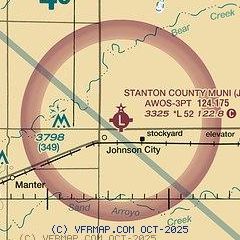
| Sectional chart |
|---|
|
| Airport distance calculator |
|---|
|
|
| Sunrise and sunset |
|---|
|
Times for 25-May-2026
| | Local
(UTC-5) | | Zulu
(UTC) |
|---|
| Morning civil twilight | | 06:01 | | 11:01 |
| Sunrise | | 06:31 | | 11:31 |
| Sunset | | 20:56 | | 01:56 |
| Evening civil twilight | | 21:26 | | 02:26 |
|
| Current date and time |
|---|
| Zulu (UTC) | 25-May-2026 05:38:46 |
|---|
| Local (UTC-5) | 25-May-2026 00:38:46 |
|---|
|
| METAR |
|---|
| KJHN | 250515Z AUTO 14012KT 10SM CLR 21/10 A3002 RMK AO2
|
KULS
17nm E | 250515Z AUTO 17015G24KT 10SM BKN065 BKN075 21/11 A3002 RMK AO2
|
|
| TAF |
|---|
KLBL
49nm SE | 241720Z 2418/2518 21015G25KT P6SM FEW200 FM242200 18015G25KT P6SM FEW200 FM250200 17012KT P6SM SCT100 FM251600 19016G26KT P6SM FEW250
|
|
| NOTAMs |
|---|
NOTAMs are issued by the DoD/FAA and will open in a separate window not controlled by AirNav.
|
|

