FAA INFORMATION EFFECTIVE 14 MAY 2026
Location
| FAA Identifier: | JSY |
| Lat/Long: | 45-21-34.3790N 117-15-13.8200W
45-21.572983N 117-15.230333W
45.3595497,-117.2538389
(estimated) |
| Elevation: | 4126.2 ft. / 1257.7 m (surveyed) |
| Variation: | 13E (2025) |
| From city: | 1 mile W of JOSEPH, OR |
| Time zone: | UTC -7 (UTC -8 during Standard Time) |
| Zip code: | 97846 |
Airport Operations
| Airport use: | Open to the public |
| Activation date: | 10/1945 |
| Control tower: | no |
| ARTCC: | SEATTLE CENTER |
| FSS: | MC MINNVILLE FLIGHT SERVICE STATION |
| NOTAMs facility: | MMV (NOTAM-D service available) |
| Attendance: | UNATNDD |
| Wind indicator: | lighted |
| Segmented circle: | yes |
| Lights: | ACTVT REIL RWY 15; PAPI RWY 15; MIRL RWY 15/33 - CTAF. |
| Beacon: | white-green (lighted land airport)
Operates sunset to sunrise. |
Airport Communications
| CTAF/UNICOM: | 122.8 |
| WX AWOS-3P: | 123.775 (541 432 0458) |
- APCH/DEP CTL SVC PRVDD BY SEATTLE ARTCC (ZSE) ON 123.95/290.55 (COTTONWOOD RCAG).
Nearby radio navigation aids
| VOR radial/distance | | VOR name | | Freq | | Var |
|---|
| BKEr017/39.0 | | BAKER CITY VOR/DME | | 115.30 | | 20E |
| NDB name | | Hdg/Dist | | Freq | | Var | | ID |
|---|
| LA GRANDE | | 074/29.9 | | 296 | | 14E | | LGD | .-.. --. -.. |
Airport Services
| Fuel available: | 100LL |
| Parking: | tiedowns |
| Airframe service: | NONE |
| Powerplant service: | NONE |
| Bottled oxygen: | NONE |
| Bulk oxygen: | NONE |
Runway Information
Runway 15/33
| Dimensions: | 5202 x 60 ft. / 1586 x 18 m |
| Surface: | asphalt, in excellent condition |
| Weight bearing capacity: | |
| Runway edge lights: | medium intensity |
| RUNWAY 15 | | RUNWAY 33 |
| Latitude: | 45-21.989635N | | 45-21.156322N |
| Longitude: | 117-15.368347W | | 117-15.092362W |
| Elevation: | 4062.8 ft. | | 4126.2 ft. |
| Traffic pattern: | left | | left |
| Runway heading: | 154 magnetic, 167 true | | 334 magnetic, 347 true |
| Markings: | basic, in fair condition | | basic, in fair condition |
| Visual slope indicator: | 2-light PAPI on left (4.00 degrees glide path) | | |
| Runway end identifier lights: | yes | | |
| Touchdown point: | yes, no lights | | yes, no lights |
| Obstructions: | 61 ft. trees, 1470 ft. from runway, 30 ft. right of centerline, 20:1 slope to clear | | 32 ft. pline, 1100 ft. from runway, 28:1 slope to clear |
Airport Ownership and Management from official FAA records
| Ownership: | Publicly-owned |
| Owner: | OREGON DEPT. OF AVIATION
3040 25TH ST SE
SALEM, OR 97302-1125
Phone 503-378-4880 |
| Manager: | STATE AIRPORTS MGR
3040 25TH ST SE
SALEM, OR 97302-1125
Phone 503-378-4880 |
Additional Remarks
| - | DURING SOUTH TAKEOFFS, POSSIBLE HAZARDOUS DOWNDRAFTS SOUTH OF ARPT UNDER SOUTH WND CONDITIONS. |
| - | POSS DEER ON ARPT USE CTN. |
| - | PLINES NEAR RY 33 AER UNMARKED. |
| - | RUNWAY ENDS NOT VISIBLE FROM EACH OTHER. |
| - | SURFACE CONDITIONS NOT REPORTED. |
| - | FOR CD CTC SEATTLE ARTCC AT 253-351-3694. |
Instrument Procedures
NOTE: All procedures below are presented as PDF files. If you need a reader for these files, you should download the free Adobe Reader.NOT FOR NAVIGATION. Please procure official charts for flight.
FAA instrument procedures published for use from 14 May 2026 at 0901Z to 11 June 2026 at 0900Z.
IAPs - Instrument Approach Procedures |
|---|
| RNAV (GPS)-A | |
download (322KB) |
| NOTE: Special Alternate Minimums apply | |
download (211KB) |
| NOTE: Special Take-Off Minimums/Departure Procedures apply | |
download (566KB) |
Other nearby airports with instrument procedures:
KLGD - La Grande/Union County Airport (32 nm W)
KBKE - Baker City Municipal Airport (39 nm SW)
KMYL - Mc Call Municipal Airport (56 nm SE)
KGIC - Idaho County Airport (59 nm NE)
KALW - Walla Walla Regional Airport (62 nm NW)
|
|

Road maps at:
MapQuest
Bing
Google
| Aerial photo |
|---|
WARNING: Photo may not be current or correct

Do you have a better or more recent aerial photo of Joseph State Airport that you would like to share? If so, please send us your photo.
|
| Sectional chart |
|---|
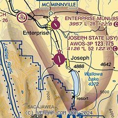
|
| Airport distance calculator |
|---|
|
|
| Sunrise and sunset |
|---|
|
Times for 30-May-2026
| | Local
(UTC-7) | | Zulu
(UTC) |
|---|
| Morning civil twilight | | 04:30 | | 11:30 |
| Sunrise | | 05:06 | | 12:06 |
| Sunset | | 20:27 | | 03:27 |
| Evening civil twilight | | 21:03 | | 04:03 |
|
| Current date and time |
|---|
| Zulu (UTC) | 30-May-2026 13:26:56 |
|---|
| Local (UTC-7) | 30-May-2026 06:26:56 |
|---|
|
| METAR |
|---|
| KJSY | 301255Z AUTO 00000KT 10SM OVC015 07/04 A3009 RMK AO2 T00650035
|
|
| TAF |
|---|
KBKE
39nm SW | 301140Z 3012/3112 33007KT P6SM BKN070 FM301700 35015G25KT P6SM SCT080 FM310400 33009KT P6SM FEW200 FM310800 VRB05KT P6SM SKC
|
|
| NOTAMs |
|---|
NOTAMs are issued by the DoD/FAA and will open in a separate window not controlled by AirNav.
|
|

