FAA INFORMATION EFFECTIVE 11 JUNE 2026
Location
| FAA Identifier: | LAL |
| Lat/Long: | 27-59-15.5000N 082-01-08.4000W
27-59.258333N 082-01.140000W
27.9876389,-82.0190000
(estimated) |
| Elevation: | 141.8 ft. / 43.2 m (surveyed) |
| Variation: | 06W (2025) |
| From city: | 4 miles SW of LAKELAND, FL |
| Time zone: | UTC -4 (UTC -5 during Standard Time) |
| Zip code: | 33811 |
Airport Operations
| Airport use: | Open to the public |
| Activation date: | 01/1943 |
| Control tower: | yes |
| ARTCC: | MIAMI CENTER |
| FSS: | SAINT PETERSBURG FLIGHT SERVICE STATION |
| NOTAMs facility: | LAL (NOTAM-D service available) |
| Attendance: | CONTINUOUS |
| Wind indicator: | yes |
| Segmented circle: | yes |
| Lights: | PAPI RWY 05 & 23, 10 & 28 OPER CONT. |
| Beacon: | white-green (lighted land airport)
Operates sunset to sunrise. |
| Fire and rescue: | ARFF index B |
| International operations: | US CUSTOMS USER FEE ARPT. |
Airport Communications
| UNICOM: | 122.95 |
| ATIS: | 118.025 |
| WX AWOS-3PT: | PHONE 863-834-2030 |
| LAKELAND GROUND: | 121.4 |
| LAKELAND TOWER: | 124.5 236.775 |
| TAMPA APPROACH: | 120.65 119.9 |
| TAMPA DEPARTURE: | 120.65 119.9 |
| EMERG: | 121.5 |
| LUBBR STAR: | 135.5 |
| MAATY STAR: | 118.8 |
| RAYZZ STAR: | 118.8 |
| WX AWOS-3 at PCM (8 nm W): | 120.025 (813-764-8259) |
| WX AWOS-3 at BOW (13 nm E): | 123.775 (863-533-9004) |
| WX ASOS at GIF (15 nm E): | 133.675 (863-956-2097) |
| WX AWOS-3PT at ZPH (16 nm NW): | 118.975 (813-780-0031) |
| WX AWOS-3 at VDF (17 nm W): | 121.125 (813-630-0924) |
Nearby radio navigation aids
| VOR radial/distance | | VOR name | | Freq | | Var |
|---|
| LAL at field | | LAKELAND VORTAC | | 116.00 | | 01E |
| PIEr087/35.6 | | ST PETERSBURG VORTAC | | 116.40 | | 05W |
Airport Services
| Fuel available: | 100LL JET-A |
| Parking: | hangars |
| Airframe service: | MAJOR |
| Powerplant service: | MAJOR |
| Bottled oxygen: | NONE |
| Bulk oxygen: | HIGH/LOW |
Runway Information
Runway 10/28
| Dimensions: | 8500 x 150 ft. / 2591 x 46 m |
| Surface: | asphalt/grooved, in excellent condition |
| Weight bearing capacity: | | Single wheel: | 50.0 | | Double wheel: | 250.0 | | Double tandem: | 550.0 | | Dual double tandem: | 1120.0 |
|
| Runway edge lights: | high intensity |
| RUNWAY 10 | | RUNWAY 28 |
| Latitude: | 27-59.354225N | | 27-59.357640N |
| Longitude: | 082-02.032118W | | 082-00.451972W |
| Elevation: | 131.7 ft. | | 141.8 ft. |
| Traffic pattern: | left | | left |
| Runway heading: | 096 magnetic, 090 true | | 276 magnetic, 270 true |
| Declared distances: | TORA:8500 TODA:8500 ASDA:8500 LDA:8500 | | TORA:8500 TODA:8500 ASDA:8500 LDA:8500 |
| Markings: | precision, in good condition | | nonprecision, in good condition |
| Visual slope indicator: | 4-light PAPI on right (3.00 degrees glide path) | | 4-light PAPI on left (3.00 degrees glide path) |
| RVR equipment: | touchdown, midfield, rollout | | touchdown, midfield, rollout |
| Approach lights: | ALSF2: standard 2,400 foot high intensity approach lighting system with centerline sequenced flashers (category II or III) | | |
| Centerline lights: | yes | | yes |
| Touchdown point: | yes, lighted | | yes, no lights |
| Instrument approach: | ILS/DME | | |
| Obstructions: | none | | 30 ft. trees, 1110 ft. from runway, 455 ft. both sides of centerline, 30:1 slope to clear |
Runway 5/23
| Dimensions: | 5000 x 150 ft. / 1524 x 46 m |
| Surface: | asphalt/grooved, in fair condition |
| Weight bearing capacity: | | Single wheel: | 94.0 | | Double wheel: | 150.0 |
|
| Runway edge lights: | high intensity |
| Operational restrictions: | RWY 05/23 NOT AVBL FOR PART 121/PART 380 OPS WITH SKED PAX CARRYING OPS MORE THAN 9 PAX SEATS AND NON-SKED PAX CARRYING OPS MORE THAN 30 PAX SEATS. |
| RUNWAY 5 | | RUNWAY 23 |
| Latitude: | 27-59.007047N | | 27-59.591977N |
| Longitude: | 082-01.222397W | | 082-00.566785W |
| Elevation: | 130.2 ft. | | 141.1 ft. |
| Traffic pattern: | left | | left |
| Runway heading: | 051 magnetic, 045 true | | 231 magnetic, 225 true |
| Declared distances: | TORA:5000 TODA:5000 ASDA:5000 LDA:5000 | | TORA:5000 TODA:5000 ASDA:5000 LDA:5000 |
| Markings: | precision, in good condition | | nonprecision, in good condition |
| Visual slope indicator: | 4-light PAPI on left (3.00 degrees glide path) | | 4-light PAPI on left (3.00 degrees glide path) |
| Touchdown point: | yes, no lights | | yes, no lights |
| Obstructions: | none | | 34 ft. trees, 1380 ft. from runway, 125 ft. left of centerline, 34:1 slope to clear |
Runway 8/26
| Dimensions: | 2208 x 60 ft. / 673 x 18 m |
| Surface: | turf, in fair condition |
| Runway edge markings: | RWY 8/26 MKD WITH PAVERS. |
| Operational restrictions: | RWY 08/26 NOT AVBL FOR PART 121/PART 380 OPS WITH SKED PAX CARRYING OPS MORE THAN 9 PAX SEATS AND NON-SKED PAX CARRYING OPS MORE THAN 30 PAX SEATS. RSTRD TO GROUP 1 ACFT UNDER 1500 LBS MTOW, VFR DAYTIME ONLY, NO TGL; PPR - 863-834-4911. |
| RUNWAY 8 | | RUNWAY 26 |
| Latitude: | 27-58.787833N | | 27-58.787885N |
| Longitude: | 082-01.505220W | | 082-01.094863W |
| Elevation: | 127.5 ft. | | 131.1 ft. |
| Traffic pattern: | left | | left |
| Runway heading: | 096 magnetic, 090 true | | 276 magnetic, 270 true |
| Displaced threshold: | 362 ft. | | 556 ft. |
| Declared distances: | TORA:1650 TODA:2010 ASDA:2205 LDA:1845 | | TORA:1845 TODA:2205 ASDA:2205 LDA:1650 |
| Markings: | NSTD, in good condition | | none, in good condition |
| Touchdown point: | yes, no lights | | yes, no lights |
| Obstructions: | 51 ft. trees, 820 ft. from runway, 200 ft. right of centerline, 16:1 slope to clear | | 55 ft. hangar, 650 ft. from runway, 145 ft. right of centerline, 11:1 slope to clear |
Airport Ownership and Management from official FAA records
| Ownership: | Publicly-owned |
| Owner: | CITY OF LAKELAND
3900 DON EMERSON DRIVE SUITE 210
LAKELAND, FL 33811-1340
Phone 863-834-3298 |
| Manager: | KRIS HALLSTRAND
3900 DON EMERSON DRIVE SUITE 210
LAKELAND, FL 33811-1340
Phone 863-834-3298 |
Additional Remarks
| A39-05/23 | PCR VALUE: 320/F/A/X/T |
| A39-10/28 | PCR VALUE: 460/F/A/X/T |
| - | BIRD ACT ON & INVOF ARPT. |
| - | USCBP USER FEE ARPT; SVC THUR-MON, 1530-2400Z. FEE CHRGD OUTSIDE OF SVC HOURS. FEE PAYABLE ON SITE. |
| - | 24 HR ADVN NOTICE OR IMT REPORTING UPON LDG FOR ACFT EQUIPPED WITH WEATHER MODIFICATION OR GEOENGINEERING EQUIP CTC ARPT OPS 863-456-7890. |
| - | TWY D, D1, & E1 UNLGTD. |
| - | PJE WITHIN 5 NM 18000 BLW SR-SS |
| - | INDEX C AVBL UPON REQ. |
Instrument Procedures
NOTE: All procedures below are presented as PDF files. If you need a reader for these files, you should download the free Adobe Reader.NOT FOR NAVIGATION. Please procure official charts for flight.
FAA instrument procedures published for use from 11 June 2026 at 0901Z to 09 July 2026 at 0900z.
STARs - Standard Terminal Arrivals |
|---|
| LUBBR FOUR (RNAV) **NEW** | |
2 pages:
[1] [2] (418KB) |
| MAATY FIVE (RNAV) **NEW** | |
2 pages:
[1] [2] (294KB) |
| MAATY FIVE (RNAV), CONT.2 **NEW** | |
download (129KB) |
| RAYZZ THREE (RNAV) **NEW** | |
2 pages:
[1] [2] (441KB) |
IAPs - Instrument Approach Procedures |
|---|
| ILS OR LOC RWY 10 | |
download (238KB) |
| ILS RWY 10 (SA CAT I) | |
download (226KB) |
| ILS RWY 10 (CAT II - III) | |
download (222KB) |
| RNAV (RNP) Z RWY 28 | |
download (185KB) |
| RNAV (GPS) RWY 05 | |
download (256KB) |
| RNAV (GPS) RWY 10 | |
download (244KB) |
| RNAV (GPS) RWY 23 | |
download (271KB) |
| RNAV (GPS) RWY 28 | |
download (241KB) |
| RNAV (GPS) Y RWY 28 | |
download (209KB) |
| VOR RWY 10 | |
download (245KB) |
| VOR RWY 28 | |
download (216KB) |
| NOTE: Special Alternate Minimums apply | |
download (147KB) |
Departure Procedures |
|---|
| OWAYY ONE (RNAV) | |
download (91KB) |
| SBOAT ONE (RNAV) | |
download (118KB) |
| NOTE: Special Take-Off Minimums/Departure Procedures apply | |
download (399KB) |
Other nearby airports with instrument procedures:
KPCM - Plant City Airport (8 nm W)
KBOW - Bartow Executive Airport (13 nm E)
KGIF - Winter Haven Regional Airport (15 nm E)
KZPH - Zephyrhills Municipal Airport (16 nm NW)
KVDF - Tampa Executive Airport (17 nm W)
|
|

Road maps at:
MapQuest
Bing
Google
| Aerial photo |
|---|
WARNING: Photo may not be current or correct
 Photo by Vicki Eifert
Taken mid November 2018
looking west.
Photo by Vicki Eifert
Taken mid November 2018
looking west.
Do you have a better or more recent aerial photo of Lakeland Linder International Airport that you would like to share? If so, please send us your photo.
|
| Sectional chart |
|---|
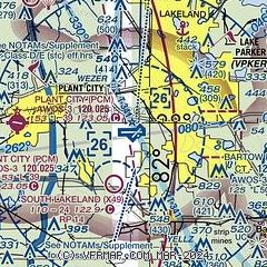
|
CAUTION: Diagram may not be current
 Download PDF
of official airport diagram from the FAA
| Airport distance calculator |
|---|
|
|
| Sunrise and sunset |
|---|
|
Times for 12-Jun-2026
| | Local
(UTC-4) | | Zulu
(UTC) |
|---|
| Morning civil twilight | | 06:05 | | 10:05 |
| Sunrise | | 06:32 | | 10:32 |
| Sunset | | 20:24 | | 00:24 |
| Evening civil twilight | | 20:50 | | 00:50 |
|
| Current date and time |
|---|
| Zulu (UTC) | 12-Jun-2026 09:19:45 |
|---|
| Local (UTC-4) | 12-Jun-2026 05:19:45 |
|---|
|
| METAR |
|---|
| KLAL | 120850Z 00000KT 10SM SKC 24/23 A3003
|
KPCM
8nm W | 120855Z AUTO 00000KT 10SM CLR 23/23 A3003 RMK AO2 T02310231 55004 $
|
KBOW
14nm E | 120855Z AUTO 00000KT 10SM CLR 24/23 A3003 RMK AO2 PWINO
|
KGIF
15nm E | 120853Z AUTO 20003KT 10SM CLR 24/22 A3004 RMK AO1 SLP169 T02440222 55002
|
KZPH
16nm NW | 120850Z AUTO 00000KT 10SM CLR 22/ A3004 RMK A02 T0224////
|
KVDF
18nm W | 120855Z AUTO 00000KT 6SM BR BKN055 23/23 A3001 RMK AO2 T02260226 55004 $
|
|
| TAF |
|---|
| KLAL | 120543Z 1206/1306 VRB03KT P6SM FEW250 FM121800 29006KT P6SM VCTS SCT040CB BKN250 PROB30 1219/1224 VRB15G25KT 3SM TSRA BKN030CB
|
|
| NOTAMs |
|---|
NOTAMs are issued by the DoD/FAA and will open in a separate window not controlled by AirNav.
|
|


