FAA INFORMATION EFFECTIVE 11 JUNE 2026
Location
| FAA Identifier: | PCM |
| Lat/Long: | 28-00-00.6000N 082-09-47.9000W
28-00.010000N 082-09.798333W
28.0001667,-82.1633056
(estimated) |
| Elevation: | 152.7 ft. / 46.5 m (surveyed) |
| Variation: | 05W (2010) |
| From city: | 2 miles SW of PLANT CITY, FL |
| Time zone: | UTC -4 (UTC -5 during Standard Time) |
| Zip code: | 33567 |
Airport Operations
| Airport use: | Open to the public |
| Activation date: | 03/1948 |
| Control tower: | no |
| ARTCC: | MIAMI CENTER |
| FSS: | SAINT PETERSBURG FLIGHT SERVICE STATION |
| NOTAMs facility: | PCM (NOTAM-D service available) |
| Attendance: | 0700-1900 |
| Wind indicator: | lighted |
| Segmented circle: | yes |
| Lights: | ACTVT REIL RWY 10 & 28; PAPI RWY 10 & 28; MIRL RWY 10/28 - CTAF. |
| Beacon: | white-green (lighted land airport)
Operates sunset to sunrise. |
Airport Communications
| CTAF/UNICOM: | 123.05 |
| WX AWOS-3: | 120.025 (813-764-8259) |
| TAMPA APPROACH: | 120.65 119.9 |
| TAMPA DEPARTURE: | 120.65 119.9 |
| WX AWOS-3PT at LAL (8 nm E): | PHONE 863-834-2030 |
| WX AWOS-3 at VDF (10 nm W): | 121.125 (813-630-0924) |
| WX AWOS-3PT at ZPH (14 nm N): | 118.975 (813-780-0031) |
| WX AWOS-3 at TPF (16 nm W): | 118.925 (813-251-6824) |
| WX ASOS at TPA (20 nm W): | 126.45 (813-296-2752) |
Nearby radio navigation aids
| VOR radial/distance | | VOR name | | Freq | | Var |
|---|
| LALr275/8.0 | | LAKELAND VORTAC | | 116.00 | | 01E |
| PIEr084/28.2 | | ST PETERSBURG VORTAC | | 116.40 | | 05W |
Airport Services
| Fuel available: | 100LL JET-A |
| Parking: | hangars and tiedowns |
| Airframe service: | MAJOR |
| Powerplant service: | MAJOR |
| Bottled oxygen: | NONE |
| Bulk oxygen: | NONE |
Runway Information
Runway 10/28
| Dimensions: | 3950 x 75 ft. / 1204 x 23 m |
| Surface: | asphalt, in excellent condition |
| Weight bearing capacity: | | PCN 7 /F/C/X/T | | Single wheel: | 21.0 |
|
| Runway edge lights: | medium intensity |
| RUNWAY 10 | | RUNWAY 28 |
| Latitude: | 28-00.033208N | | 27-59.985390N |
| Longitude: | 082-10.165047W | | 082-09.432610W |
| Elevation: | 151.5 ft. | | 137.9 ft. |
| Traffic pattern: | left | | left |
| Runway heading: | 099 magnetic, 094 true | | 279 magnetic, 274 true |
| Displaced threshold: | 200 ft. | | no |
| Markings: | nonprecision, in good condition | | nonprecision, in good condition |
| Visual slope indicator: | 2-light PAPI on left (3.00 degrees glide path) | | 2-light PAPI on left (3.00 degrees glide path) |
| Runway end identifier lights: | yes | | yes |
| Touchdown point: | yes, no lights | | yes, no lights |
| Obstructions: | 15 ft. road, 305 ft. from runway, 250 ft. right of centerline, 7:1 slope to clear
RWY 10 APCH RATIO 34:1 TO DTHR. | | 43 ft. trees, 1150 ft. from runway, 275 ft. left of centerline, 22:1 slope to clear |
Airport Ownership and Management from official FAA records
| Ownership: | Publicly-owned |
| Owner: | HILLSBOROUGH COUNTY AVIATION AUTH
P.O. BOX 22287
TAMPA, FL 33622
Phone 813-870-8711 |
| Manager: | BRETT FAY
PO BOX 22287
TAMPA, FL 33622
Phone 813-870-8735
AIRPORT PHYSICAL ADDRESS: 4007 AIRPORT RD, PLANT CITY, FL 33563 |
Additional Remarks
| A30A-10 | NOISE ABATEMENT PROC IN EFCT FOR DEP; NO TURNS BLW 500 FT AGL UNLESS DIRECTED BY ATC. |
| - | NMRS 1099 FT & 1549 FT MSL TWRS 12 NM SSW. |
| - | GCO AVBL ON FREQ 121.725 TAMPA CLNC DEL, FOR PCM. |
| - | FOR CD IF UNA VIA GCO CTC TAMPA APCH AT 813-878-2528. |
| - | VFR ACFT ARR/DEP PLANT CITY ARPT, EXER CTN DUE TO SML AND HVY TBJT ACFT TRSNG ARPT TFC AREA 1700 FT AND ABV ON APCH TO LAKELAND INTL 6.5 NM EAST. |
| - | 24 HR ADVN NOTICE OR IMT REPORTING UPON LDG FOR ACFT EQUIPPED WITH WEATHER MODIFICATION OR GEOENGINEERING EQUIP. 813-870-8770 EXT. 3 |
Instrument Procedures
NOTE: All procedures below are presented as PDF files. If you need a reader for these files, you should download the free Adobe Reader.NOT FOR NAVIGATION. Please procure official charts for flight.
FAA instrument procedures published for use from 11 June 2026 at 0901Z to 09 July 2026 at 0900z.
IAPs - Instrument Approach Procedures |
|---|
| RNAV (GPS) RWY 10 | |
download (238KB) |
| RNAV (GPS) RWY 28 | |
download (231KB) |
| VOR RWY 28 | |
download (184KB) |
| NOTE: Special Alternate Minimums apply | |
download |
| NOTE: Special Take-Off Minimums/Departure Procedures apply | |
download (162KB) |
Other nearby airports with instrument procedures:
KLAL - Lakeland Linder International Airport (8 nm E)
KVDF - Tampa Executive Airport (10 nm W)
KZPH - Zephyrhills Municipal Airport (14 nm N)
KTPF - Peter O Knight Airport (16 nm W)
KTPA - Tampa International Airport (20 nm W)
|
|

Road maps at:
MapQuest
Bing
Google
| Aerial photo |
|---|
WARNING: Photo may not be current or correct
 Photo courtesy of PhotosFromTheAir.com
Photo taken 27-Feb-2012
looking west.
Photo courtesy of PhotosFromTheAir.com
Photo taken 27-Feb-2012
looking west.
Do you have a better or more recent aerial photo of Plant City Airport that you would like to share? If so, please send us your photo.
|
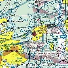
| Sectional chart |
|---|
|
| Airport distance calculator |
|---|
|
|
| Sunrise and sunset |
|---|
|
Times for 17-Jun-2026
| | Local
(UTC-4) | | Zulu
(UTC) |
|---|
| Morning civil twilight | | 06:06 | | 10:06 |
| Sunrise | | 06:33 | | 10:33 |
| Sunset | | 20:26 | | 00:26 |
| Evening civil twilight | | 20:53 | | 00:53 |
|
| Current date and time |
|---|
| Zulu (UTC) | 18-Jun-2026 02:55:20 |
|---|
| Local (UTC-4) | 17-Jun-2026 22:55:20 |
|---|
|
| METAR |
|---|
| KPCM | 180235Z AUTO 21005KT 10SM CLR 28/24 A3003 RMK AO2 T02840242 $
|
KLAL
8nm E | 180150Z 20003KT 10SM SKC 28/25 A3003
|
KVDF
10nm W | 180235Z AUTO 23008KT 9SM CLR 29/25 A3002 RMK AO2 T02870255 $
|
KZPH
14nm N | 180235Z AUTO 17005KT 10SM CLR 27/23 A3004 RMK A02 T02730235
|
KTPF
16nm W | 180235Z AUTO 23008KT 10SM CLR 29/25 A3001 RMK AO2 T02920252 $
|
KTPA
20nm W | 180153Z 20008KT 10SM FEW070 BKN250 29/24 A3001 RMK AO2 SLP162 T02890244
|
|
| TAF |
|---|
KLAL
8nm E | 171725Z 1718/1818 20011G19KT P6SM SCT040 BKN250 FM180000 VRB03KT P6SM BKN250
|
KTPA
20nm W | 171725Z 1718/1824 21014KT P6SM SCT040 BKN250 FM172000 21014G21KT P6SM SCT040 BKN250 FM172200 20008KT P6SM SCT040 BKN250
|
|
| NOTAMs |
|---|
NOTAMs are issued by the DoD/FAA and will open in a separate window not controlled by AirNav.
|
|


