FAA INFORMATION EFFECTIVE 14 MAY 2026
Location
| FAA Identifier: | LCG |
| Lat/Long: | 42-14-29.7807N 096-58-56.1756W
42-14.496345N 096-58.936260W
42.2416057,-96.9822710
(estimated) |
| Elevation: | 1431.7 ft. / 436 m (estimated) |
| Variation: | 06E (1990) |
| From city: | 2 miles E of WAYNE, NE |
| Time zone: | UTC -5 (UTC -6 during Standard Time) |
| Zip code: | 68787 |
Airport Operations
| Airport use: | Open to the public |
| Activation date: | 03/1941 |
| Control tower: | no |
| ARTCC: | MINNEAPOLIS CENTER |
| FSS: | COLUMBUS FLIGHT SERVICE STATION |
| NOTAMs facility: | LCG (NOTAM-D service available) |
| Attendance: | DAWN - DUSK |
| Wind indicator: | lighted |
| Segmented circle: | yes |
| Lights: | PAPI RWY 18 & 36; MIRL RWYS 05/23, 18/36; OPR SS-2300. AFT 2300, ACTVT - CTAF. |
| Beacon: | white-green (lighted land airport)
Operates sunset to sunrise. |
Airport Communications
| CTAF/UNICOM: | 122.8 |
| WX AWOS-3: | 120.125 (402-375-0111) |
| SIOUX CITY APPROACH: | 124.6 |
| SIOUX CITY DEPARTURE: | 124.6 |
- APCH/DEP SVC PRVDD BY MINNEAPOLIS ARTCC ON FREQS 125.025/235.625 (SIOUX CITY RCAG) WHEN SIOUX CITY APCH CTL CLSD.
Nearby radio navigation aids
| VOR radial/distance | | VOR name | | Freq | | Var |
|---|
| OFKr045/25.2 | | NORFOLK VOR/DME | | 114.35 | | 08E |
Airport Services
| Fuel available: | 100LL |
| Parking: | hangars and tiedowns |
| Airframe service: | MAJOR |
| Powerplant service: | MAJOR |
| Bottled oxygen: | NONE |
| Bulk oxygen: | NONE |
Runway Information
Runway 18/36
| Dimensions: | 4201 x 75 ft. / 1280 x 23 m |
| Surface: | concrete, in excellent condition |
| Weight bearing capacity: | |
| Runway edge lights: | medium intensity |
| Operational restrictions: | RWY 36 END APCH CROSSES RWY 31 END APCH. |
| RUNWAY 18 | | RUNWAY 36 |
| Latitude: | 42-14.939413N | | 42-14.248087N |
| Longitude: | 096-58.806320W | | 096-58.830242W |
| Elevation: | 1427.7 ft. | | 1431.7 ft. |
| Traffic pattern: | left | | left |
| Runway heading: | 175 magnetic, 181 true | | 355 magnetic, 001 true |
| Markings: | nonprecision, in good condition | | nonprecision, in good condition |
| Visual slope indicator: | 2-light PAPI on left (3.00 degrees glide path) | | 2-light PAPI on left (3.00 degrees glide path) |
| Touchdown point: | yes, no lights | | yes, no lights |
Runway 5/23
| Dimensions: | 3406 x 60 ft. / 1038 x 18 m |
| Surface: | concrete, in excellent condition |
| Weight bearing capacity: | |
| Runway edge lights: | medium intensity |
| RUNWAY 5 | | RUNWAY 23 |
| Latitude: | 42-14.250875N | | 42-14.580003N |
| Longitude: | 096-59.271353W | | 096-58.660492W |
| Elevation: | 1430.7 ft. | | 1426.1 ft. |
| Traffic pattern: | left | | left |
| Runway heading: | 048 magnetic, 054 true | | 228 magnetic, 234 true |
| Markings: | nonprecision, in good condition | | nonprecision, in good condition |
| Touchdown point: | yes, no lights | | yes, no lights |
Runway 13/31
| Dimensions: | 2070 x 120 ft. / 631 x 37 m |
| Surface: | turf, in good condition |
| Operational restrictions: | RWY 31 END APCH CROSSES RWY 36 END APCH. NOT PLOWED WINTER MONTHS. |
| RUNWAY 13 | | RUNWAY 31 |
| Latitude: | 42-14.551495N | | 42-14.312088N |
| Longitude: | 096-59.290058W | | 096-58.963713W |
| Elevation: | 1428.7 ft. | | 1426.3 ft. |
| Traffic pattern: | left | | left |
| Runway heading: | 129 magnetic, 135 true | | 309 magnetic, 315 true |
| Touchdown point: | yes, no lights | | yes, no lights |
Airport Ownership and Management from official FAA records
| Ownership: | Publicly-owned |
| Owner: | WAYNE AIRPORT AUTHORITY
PO BOX 8
WAYNE, NE 68787-0008
Phone 402-375-1733
TRAVIS MEYER , OPERATIONS MANAGER, PHONE 402-369-6920. |
| Manager: | TOM BECKER
56395 881 ROAD
HARTINGTON, NE 68739-0188
Phone 402-841-0659 |
Additional Remarks
| A57-18 | RWY 18 CLNC SLOPE 22:1 DUE TO ROAD 10 FT ABV; 423 FT FM RWY END 283 FT L/R. |
| A57-05 | RWY 05 CLNC SLOPE 25:1 DUE TO POLE 39 FT ABV; 1209 FT FM RWY END 66 FT L. |
| A57-23 | RWY 23 CLNC SLOPE 39:1 DUE TO HILL 134 FT ABV; 5500 FT FM RWY END 850 FT L. |
| - | DEER ON AND INVOF ARPT. |
| - | FOR CD CTC SIOUX CITY APCH AT 712-293-2482. WHEN SIOUX CITY APCH CLSD, FOR CD CTC MINNEAPOLIS ARTCC AT 651-463-5588. |
Instrument Procedures
NOTE: All procedures below are presented as PDF files. If you need a reader for these files, you should download the free Adobe Reader.NOT FOR NAVIGATION. Please procure official charts for flight.
FAA instrument procedures published for use from 14 May 2026 at 0901Z to 11 June 2026 at 0900Z.
IAPs - Instrument Approach Procedures |
|---|
| RNAV (GPS) RWY 18 | |
download (200KB) |
| RNAV (GPS) RWY 23 | |
download (208KB) |
| RNAV (GPS) RWY 36 | |
download (223KB) |
| NOTE: Special Alternate Minimums apply | |
download (146KB) |
| NOTE: Special Take-Off Minimums/Departure Procedures apply | |
download (360KB) |
Other nearby airports with instrument procedures:
0C4 - Pender Municipal Airport (14 nm SE)
0B4 - Hartington Municipal Airport/Bud Becker Field (25 nm NW)
KOFK - Norfolk Regional Airport/Karl Stefan Memorial Field (25 nm SW)
KSUX - Sioux Gateway Airport/Brigadier General Bud Day Field (28 nm E)
KVMR - Harold Davidson Field Airport (31 nm N)
|
|

Road maps at:
MapQuest
Bing
Google
| Aerial photo |
|---|
WARNING: Photo may not be current or correct
 Photo by Tavo Gutierrez
Photo taken 03-Jul-2011
looking south.
Photo by Tavo Gutierrez
Photo taken 03-Jul-2011
looking south.
Do you have a better or more recent aerial photo of Wayne Municipal Airport/Stan Morris Field that you would like to share? If so, please send us your photo.
|
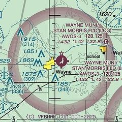
| Sectional chart |
|---|
|
| Airport distance calculator |
|---|
|
|
| Sunrise and sunset |
|---|
|
Times for 28-May-2026
| | Local
(UTC-5) | | Zulu
(UTC) |
|---|
| Morning civil twilight | | 05:24 | | 10:24 |
| Sunrise | | 05:57 | | 10:57 |
| Sunset | | 20:53 | | 01:53 |
| Evening civil twilight | | 21:27 | | 02:27 |
|
| Current date and time |
|---|
| Zulu (UTC) | 28-May-2026 10:08:33 |
|---|
| Local (UTC-5) | 28-May-2026 05:08:33 |
|---|
|
| METAR |
|---|
| KLCG | 280935Z AUTO 00000KT 10SM SCT090 16/13 A3007 RMK AO2 T01590128
|
|
| TAF |
|---|
KOFK
25nm SW | 280520Z 2806/2906 18006KT P6SM BKN250 FM281500 13014KT P6SM FEW080 OVC250 FM290000 15010KT P6SM SCT090 OVC200
|
KSUX
28nm E | 280524Z 2806/2906 VRB04KT P6SM BKN250 FM281400 11008KT P6SM BKN250 FM281700 14012G19KT P6SM BKN180 FM290200 13009KT P6SM OVC120
|
|
| NOTAMs |
|---|
NOTAMs are issued by the DoD/FAA and will open in a separate window not controlled by AirNav.
|
|

