FAA INFORMATION EFFECTIVE 14 MAY 2026
Location
| FAA Identifier: | MGR |
| Lat/Long: | 31-05-08.0860N 083-48-10.1130W
31-05.134767N 083-48.168550W
31.0855794,-83.8028092
(estimated) |
| Elevation: | 297.1 ft. / 90.6 m (surveyed) |
| Variation: | 05W (2015) |
| From city: | 6 miles S of MOULTRIE, GA |
| Time zone: | UTC -4 (UTC -5 during Standard Time) |
| Zip code: | 31768 |
Airport Operations
| Airport use: | Open to the public |
| Control tower: | no |
| ARTCC: | JACKSONVILLE CENTER |
| FSS: | MACON FLIGHT SERVICE STATION |
| NOTAMs facility: | MCN (NOTAM-D service available) |
| Attendance: | 0730-DUSK |
| Wind indicator: | lighted |
| Segmented circle: | yes |
| Lights: | MIRL RWY 04/22 PRESET ON LOW INTST DUSK-2200; TO INCR INTST & ACTVT AFTER 2200 - CTAF. ACTVT PAPI RWY 04 & 22 - CTAF. |
| Beacon: | white-green (lighted land airport)
Operates sunset to sunrise. |
| Taxiway lights: | TWY LGTS RWY 4-22 ONLY. |
Airport Communications
| CTAF/UNICOM: | 122.8 |
| WX AWOS-3PT: | 118.925 (229-890-5320) |
| VALDOSTA APPROACH: | 126.6 ;EAST OF VAD 360-VAD 180 132.375 ;WEST OF VAD R-360 RADIAL |
| VALDOSTA DEPARTURE: | 126.6 ;EAST OF VAD 360-VAD 180 132.375 ;WEST OF VAD R-360 RADIAL |
| IC: | 126.6 ;EAST OF VAD 360-VAD 180 |
| WX AWOS-3PT at TVI (12 nm S): | 119.175 (229-225-4336) |
| WX AWOS-3PT at 15J (18 nm E): | 118.025 (229-896-4223) |
- APCH/DEP SVC PRVDD BY JACKSONVILLE ARTCC ON FREQS 127.575/269.025 (ALMA RCAG) WHEN VALDOSTA APCH CTL CLSD.
Nearby radio navigation aids
| VOR radial/distance | | VOR name | | Freq | | Var |
|---|
| GEFr357/32.1 | | GREENVILLE VORTAC | | 113.65 | | 01E |
| OTKr306/32.6 | | VALDOSTA VOR/DME | | 114.80 | | 02W |
| NDB name | | Hdg/Dist | | Freq | | Var | | ID |
|---|
| CAIDY | | 061/21.8 | | 338 | | 04W | | CYR | -.-. -.-- .-. |
| WILLIS | | 084/37.7 | | 359 | | 04W | | LYZ | .-.. -.-- --.. |
Airport Services
| Fuel available: | 100LL JET-A+ |
| Parking: | hangars and tiedowns |
| Airframe service: | MAJOR |
| Powerplant service: | MAJOR |
| Bottled oxygen: | HIGH/LOW |
| Bulk oxygen: | NONE |
Runway Information
Runway 4/22
| Dimensions: | 6000 x 100 ft. / 1829 x 30 m |
| Surface: | asphalt/grooved, in good condition |
| Weight bearing capacity: | | Single wheel: | 30.0 | | Double wheel: | 49.0 | | Double tandem: | 98.0 |
|
| Runway edge lights: | medium intensity |
| RUNWAY 4 | | RUNWAY 22 |
| Latitude: | 31-04.829588N | | 31-05.600113N |
| Longitude: | 083-48.569455W | | 083-47.847732W |
| Elevation: | 269.1 ft. | | 297.1 ft. |
| Traffic pattern: | left | | left |
| Runway heading: | 044 magnetic, 039 true | | 224 magnetic, 219 true |
| Displaced threshold: | no | | 372 ft. |
| Declared distances: | TORA:6000 TODA:6000 ASDA:6000 LDA:6000 | | TORA:6000 TODA:6000 ASDA:6000 LDA:5628 |
| Markings: | nonprecision, in fair condition | | nonprecision, in fair condition |
| Visual slope indicator: | 2-light PAPI on left (3.00 degrees glide path) | | 2-light PAPI on left (3.00 degrees glide path) |
| Touchdown point: | yes, no lights | | yes, no lights |
| Obstructions: | 25 ft. trees, 725 ft. from runway, 301 ft. right of centerline, 21:1 slope to clear | | 89 ft. trees, 1980 ft. from runway, 414 ft. right of centerline, 20:1 slope to clear |
Runway 16/34
| Dimensions: | 3878 x 75 ft. / 1182 x 23 m |
| Surface: | asphalt, in good condition |
| Weight bearing capacity: | |
| RUNWAY 16 | | RUNWAY 34 |
| Latitude: | 31-05.309923N | | 31-04.711692N |
| Longitude: | 083-48.237995W | | 083-47.975120W |
| Elevation: | 288.2 ft. | | 270.1 ft. |
| Traffic pattern: | left | | left |
| Runway heading: | 164 magnetic, 159 true | | 344 magnetic, 339 true |
| Markings: | basic, in good condition | | basic, in good condition |
| Touchdown point: | yes, no lights | | yes, no lights |
| Obstructions: | 72 ft. trees, 992 ft. from runway, 203 ft. left of centerline, 11:1 slope to clear | | 9 ft. trees, 281 ft. from runway, 9:1 slope to clear |
Airport Ownership and Management from official FAA records
| Ownership: | Publicly-owned |
| Owner: | MOULTRIE COLQUITT COUNTY APT AUTH
300 CAMELLIA DRIVE
MOULTRIE, GA 31768
Phone (229) 873-4278 |
| Manager: | ALAN MATHIS
189 AIRPORT DRIVE
MOULTRIE, GA 31768
Phone 229-890-9464 |
Additional Remarks
| - | FOR CD CTC VALDOSTA APCH AT 229-257-2207, WHEN APCH CLSD CTC JACKSONVILLE ARTCC AT 904-845-1592. |
Instrument Procedures
NOTE: All procedures below are presented as PDF files. If you need a reader for these files, you should download the free Adobe Reader.NOT FOR NAVIGATION. Please procure official charts for flight.
FAA instrument procedures published for use from 14 May 2026 at 0901Z to 11 June 2026 at 0900Z.
IAPs - Instrument Approach Procedures |
|---|
| RNAV (GPS) RWY 04 | |
download (205KB) |
| RNAV (GPS) RWY 22 | |
download (213KB) |
| NOTE: Special Alternate Minimums apply | |
download (158KB) |
| NOTE: Special Take-Off Minimums/Departure Procedures apply | |
download (594KB) |
Other nearby airports with instrument procedures:
KTVI - Thomasville Regional Airport (12 nm S)
15J - Cook County Airport (18 nm E)
4J5 - Quitman Brooks County Airport (20 nm SE)
70J - Cairo-Grady County Airport (22 nm SW)
KCXU - Camilla-Mitchell County Airport (23 nm W)
|
|

Road maps at:
MapQuest
Bing
Google
| Aerial photo |
|---|
WARNING: Photo may not be current or correct
 Photo courtesy of AirNav, LLC
Photo taken 07-May-2017
looking southeast.
Photo courtesy of AirNav, LLC
Photo taken 07-May-2017
looking southeast.
Do you have a better or more recent aerial photo of Moultrie Municipal Airport that you would like to share? If so, please send us your photo.
|
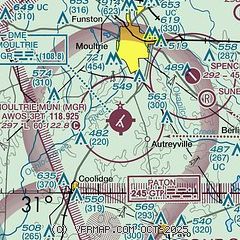
| Sectional chart |
|---|
|
CAUTION: Diagram may not be current

| Airport distance calculator |
|---|
|
|
| Sunrise and sunset |
|---|
|
Times for 20-May-2026
| | Local
(UTC-4) | | Zulu
(UTC) |
|---|
| Morning civil twilight | | 06:11 | | 10:11 |
| Sunrise | | 06:38 | | 10:38 |
| Sunset | | 20:26 | | 00:26 |
| Evening civil twilight | | 20:53 | | 00:53 |
|
| Current date and time |
|---|
| Zulu (UTC) | 20-May-2026 12:58:02 |
|---|
| Local (UTC-4) | 20-May-2026 08:58:02 |
|---|
|
| METAR |
|---|
| KMGR | 201235Z AUTO 13005KT 10SM CLR 23/21 A3015 RMK AO2 T02310213 $
|
KTVI
12nm S | 201235Z AUTO 11003KT 10SM CLR 23/21 A3016 RMK AO2
|
|
| TAF |
|---|
KVAD
32nm E | 201210Z 2012/2114 12003KT 9999 SCT200 QNH3011INS BECMG 2012/2013 08003KT 9999 SCT200 QNH2999INS BECMG 2102/2103 14003KT 9999 SCT060 QNH3003INS BECMG 2108/2109 20003KT 9999 SCT010 SCT030 QNH3002INS TX33/2020Z TN20/2012Z
|
KVLD
34nm SE | 201120Z 2012/2112 VRB02KT P6SM SCT080 TEMPO 2012/2014 00000KT 1SM BR SKC FM201700 09002KT P6SM SCT100 AMD NOT SKED
|
KABY
34nm NW | 201120Z 2012/2112 00000KT P6SM FEW120 FM201700 15003KT P6SM SCT100
|
|
| NOTAMs |
|---|
NOTAMs are issued by the DoD/FAA and will open in a separate window not controlled by AirNav.
|
|


