FAA INFORMATION EFFECTIVE 14 MAY 2026
Location
| FAA Identifier: | 15J |
| Lat/Long: | 31-08-12.3280N 083-27-15.2040W
31-08.205467N 083-27.253400W
31.1367578,-83.4542233
(estimated) |
| Elevation: | 235.2 ft. / 71.7 m (surveyed) |
| Variation: | 04W (2000) |
| From city: | 1 mile W of ADEL, GA |
| Time zone: | UTC -4 (UTC -5 during Standard Time) |
| Zip code: | 31620 |
Airport Operations
| Airport use: | Open to the public |
| Activation date: | 01/1943 |
| Control tower: | no |
| ARTCC: | JACKSONVILLE CENTER |
| FSS: | MACON FLIGHT SERVICE STATION |
| NOTAMs facility: | MCN (NOTAM-D service available) |
| Attendance: | MON - SAT 0800-1700 |
| Wind indicator: | lighted |
| Segmented circle: | yes |
| Lights: | ACTVT PAPI RWY 05 & 23; MIRL RWY 05/23 - CTAF. |
| Beacon: | white-green (lighted land airport)
Operates sunset to sunrise. |
Airport Communications
| CTAF/UNICOM: | 122.8 |
| WX AWOS-3PT: | 118.025 (229-896-4223) |
| VALDOSTA APPROACH: | 126.6 ;EAST OF VAD 360-VAD 180 132.375 ;WEST OF VAD R-360 RADIAL |
| VALDOSTA DEPARTURE: | 126.6 ;EAST OF VAD 360-VAD 180 132.375 ;WEST OF VAD R-360 RADIAL |
| IC: | 126.6 ;EAST OF VAD 360-VAD 180 |
| WX AWOS-3PT at TMA (18 nm N): | 118.525 (229-386-8937) |
| WX AWOS-3PT at MGR (18 nm W): | 118.925 (229-890-5320) |
- APCH/DEP SVC PRVDD BY JACKSONVILLE ARTCC ON FREQS 133.7/323.3(VALDOSTA RCAG) WHEN VALDOSTA APCH CTL CLSD.
Nearby radio navigation aids
| VOR radial/distance | | VOR name | | Freq | | Var |
|---|
| OTKr339/23.2 | | VALDOSTA VOR/DME | | 114.80 | | 02W |
| GEFr025/39.0 | | GREENVILLE VORTAC | | 113.65 | | 01E |
| NDB name | | Hdg/Dist | | Freq | | Var | | ID |
|---|
| FITZGERALD | | 201/29.8 | | 362 | | 05W | | SUR | ... ..- .-. |
| CAIDY | | 072/39.2 | | 338 | | 04W | | CYR | -.-. -.-- .-. |
Airport Services
| Fuel available: | 100LL JET-A+ |
| Parking: | tiedowns |
| Airframe service: | MAJOR |
| Powerplant service: | MAJOR |
| Bottled oxygen: | NONE |
| Bulk oxygen: | NONE |
Runway Information
Runway 5/23
| Dimensions: | 5502 x 100 ft. / 1677 x 30 m |
| Surface: | asphalt, in good condition |
| Weight bearing capacity: | | Single wheel: | 30.0 | | Double wheel: | 30.0 |
|
| Runway edge lights: | medium intensity |
| RUNWAY 5 | | RUNWAY 23 |
| Latitude: | 31-07.787038N | | 31-08.402077N |
| Longitude: | 083-27.722618W | | 083-26.947140W |
| Elevation: | 233.5 ft. | | 234.7 ft. |
| Traffic pattern: | left | | left |
| Runway heading: | 051 magnetic, 047 true | | 231 magnetic, 227 true |
| Displaced threshold: | 500 ft. | | 151 ft. |
| Markings: | nonprecision, in good condition | | nonprecision, in good condition |
| Visual slope indicator: | 2-light PAPI on left (3.00 degrees glide path) | | 2-light PAPI on left (3.00 degrees glide path) |
| Touchdown point: | yes, no lights | | yes, no lights |
| Obstructions: | 12 ft. other, 224 ft. from runway, 2:1 slope to clear
PLOWED FLD 224 FT FROM EOR. 12 FT FARM EQPT POSS. | | 15 ft. road, 350 ft. from runway, 262 ft. right of centerline, 10:1 slope to clear |
Runway 15/33
| Dimensions: | 3999 x 100 ft. / 1219 x 30 m |
| Surface: | asphalt, in good condition |
| Weight bearing capacity: | | Single wheel: | 30.0 | | Double wheel: | 30.0 |
|
| RUNWAY 15 | | RUNWAY 33 |
| Latitude: | 31-08.627738N | | 31-08.088298N |
| Longitude: | 083-27.361973W | | 083-26.920640W |
| Elevation: | 234.7 ft. | | 234.6 ft. |
| Traffic pattern: | left | | left |
| Runway heading: | 149 magnetic, 145 true | | 329 magnetic, 325 true |
| Displaced threshold: | 599 ft. | | 349 ft. |
| Declared distances: | TORA:3999 TODA:3999 ASDA:3859 LDA:3259 | | TORA:3999 TODA:3999 ASDA:3999 LDA:3650 |
| Markings: | basic, in good condition | | basic, in good condition |
| Touchdown point: | yes, no lights | | yes, no lights |
| Obstructions: | 15 ft. road, 400 ft. from runway, 140 ft. right of centerline, 13:1 slope to clear
RWY 15 APCH RATIO 20:1 TO DSPLCD THR. | | 15 ft. road, 260 ft. from runway, 4:1 slope to clear
RWY 33 APCH RATIO 12:1 TO DSPLCD THR. |
Airport Ownership and Management from official FAA records
| Ownership: | Publicly-owned |
| Owner: | COOK COUNTY
1200 SO. HUTCHISON
ADEL, GA 31620
Phone 229-896-2266 |
| Manager: | JERRY CONNELL
160 AIRPORT RD.
ADEL, GA 31620
Phone (229) 507-1340 |
Additional Remarks
| - | FOR CD CTC VALDOSTA APCH AT 229-257-2207, WHEN APCH CLSD CTC JACKSONVILLE ARTCC AT 904-845-1592. |
| - | UNICOM IS UNMON. |
Instrument Procedures
NOTE: All procedures below are presented as PDF files. If you need a reader for these files, you should download the free Adobe Reader.NOT FOR NAVIGATION. Please procure official charts for flight.
FAA instrument procedures published for use from 14 May 2026 at 0901Z to 11 June 2026 at 0900Z.
IAPs - Instrument Approach Procedures |
|---|
| RNAV (GPS) RWY 05 | |
download (167KB) |
| RNAV (GPS) RWY 23 | |
download (189KB) |
| NOTE: Special Alternate Minimums apply | |
download (159KB) |
| NOTE: Special Alternate Minimums apply | |
download (159KB) |
| NOTE: Special Take-Off Minimums/Departure Procedures apply | |
download (514KB) |
Other nearby airports with instrument procedures:
4J2 - Berrien County Airport (13 nm E)
KVAD - Moody Air Force Base (17 nm SE)
KTMA - Henry Tift Myers Airport (18 nm N)
KMGR - Moultrie Municipal Airport (18 nm W)
4J5 - Quitman Brooks County Airport (21 nm S)
|
|

Road maps at:
MapQuest
Bing
Google
| Aerial photo |
|---|
WARNING: Photo may not be current or correct

Do you have a better or more recent aerial photo of Cook County Airport that you would like to share? If so, please send us your photo.
|
| Sectional chart |
|---|
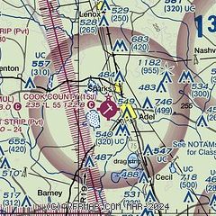
|
| Airport distance calculator |
|---|
|
|
| Sunrise and sunset |
|---|
|
Times for 22-May-2026
| | Local
(UTC-4) | | Zulu
(UTC) |
|---|
| Morning civil twilight | | 06:08 | | 10:08 |
| Sunrise | | 06:35 | | 10:35 |
| Sunset | | 20:26 | | 00:26 |
| Evening civil twilight | | 20:53 | | 00:53 |
|
| Current date and time |
|---|
| Zulu (UTC) | 22-May-2026 12:31:37 |
|---|
| Local (UTC-4) | 22-May-2026 08:31:37 |
|---|
|
| METAR |
|---|
KVAD
17nm SE | 212255Z AUTO 27004KT 10SM FEW075 28/20 A2995 RMK AO2 SLP142 $
|
KTMA
18nm N | 221215Z AUTO 13004KT 10SM FEW180 23/22 A3006 RMK AO2 T02300224 $
|
KMGR
18nm W | 221215Z AUTO 14004KT 10SM CLR 22/22 A3005 RMK AO2 T02220222 $
|
KVLD
24nm SE | 221200Z 130/03KT 10SM CLR 22/20 A3002 RMK A02
|
KTVI
26nm SW | 221215Z AUTO 13004KT 10SM CLR 23/21 A3005 RMK AO2
|
|
| TAF |
|---|
KVAD
17nm SE | 211900Z 2119/2222 18006KT 9999 SCT030 SCT200 QNH2995INS BECMG 2119/2120 22006KT 8000 -SHRA SCT060 SCT200 QNH2992INS TEMPO 2120/2123 VRB15G25KT 4800 -TSRA BKN060CB BECMG 2203/2204 18006KT 9999 NSW SCT060 SCT200 QNH2997INS BECMG 2209/2210 18006KT 4800 BR SCT005 SCT200 QNH3000INS BECMG 2213/2214 18006KT 9999 NSW SCT030 SCT140 SCT200 QNH3000INS BECMG 2215/2216 18010G15KT 9999 VCSH BKN030 BKN200 QNH3001INS BECMG 2217/2218 18010G15KT 8000 -SHRA BKN030 BKN200 QNH3003INS TEMPO 2218/2220 VRB15G25KT 4800
|
|
| NOTAMs |
|---|
NOTAMs are issued by the DoD/FAA and will open in a separate window not controlled by AirNav.
|
|


