FAA INFORMATION EFFECTIVE 14 MAY 2026
Location
| FAA Identifier: | MLC |
| Lat/Long: | 34-52-56.6000N 095-47-00.5000W
34-52.943333N 095-47.008333W
34.8823889,-95.7834722
(estimated) |
| Elevation: | 770.8 ft. / 234.9 m (surveyed) |
| Variation: | 02E (2020) |
| From city: | 3 miles SW of MC ALESTER, OK |
| Time zone: | UTC -5 (UTC -6 during Standard Time) |
| Zip code: | 74501 |
Airport Operations
| Airport use: | Open to the public |
| Activation date: | 06/1951 |
| Control tower: | no |
| ARTCC: | FORT WORTH CENTER |
| FSS: | MC ALESTER FLIGHT SERVICE STATION |
| NOTAMs facility: | MLC (NOTAM-D service available) |
| Attendance: | 0800-1700
AFT HR - 918-329-8330. |
| Wind indicator: | lighted |
| Segmented circle: | no |
| Lights: | ACTVT MALS RWY 02; REIL RWY 20; PAPI RWY 02 & 20; MIRL RWY 02/20 - CTAF. MIRL RWY 02/20 SET LOW INTST, INCR INTST - CTAF. |
| Beacon: | white-green (lighted land airport)
Operates sunset to sunrise. |
Airport Communications
| CTAF/UNICOM: | 122.95 |
| WX ASOS: | 120.425 (918-426-7674) |
- APCH/DEP CTL SVC PRVDD BY FORT WORTH ARTCC (ZFW) ON FREQS 132.2/338.35 (MC ALESTER RCAG).
Nearby radio navigation aids
| NDB name | | Hdg/Dist | | Freq | | Var | | ID |
|---|
| HENRYETTA | | 156/33.3 | | 267 | | 04E | | HET | .... . - |
Airport Services
| Fuel available: | 100LL JET-A+ |
| Parking: | hangars and tiedowns |
| Airframe service: | MAJOR |
| Powerplant service: | MAJOR |
Runway Information
Runway 2/20
| Dimensions: | 5602 x 100 ft. / 1707 x 30 m |
| Surface: | concrete, in good condition |
| Weight bearing capacity: | | Single wheel: | 52.0 | | Double wheel: | 70.0 | | Double tandem: | 120.0 |
|
| Runway edge lights: | medium intensity |
| RUNWAY 2 | | RUNWAY 20 |
| Latitude: | 34-52.510960N | | 34-53.376730N |
| Longitude: | 095-47.203548W | | 095-46.813530W |
| Elevation: | 741.6 ft. | | 770.8 ft. |
| Traffic pattern: | left | | left |
| Runway heading: | 018 magnetic, 020 true | | 198 magnetic, 200 true |
| Markings: | nonprecision, in good condition | | nonprecision, in good condition |
| Visual slope indicator: | 4-light PAPI on left (3.00 degrees glide path) | | 4-light PAPI on left (3.00 degrees glide path) |
| Approach lights: | MALS: 1,400 foot medium intensity approach lighting system | | |
| Runway end identifier lights: | | | yes |
| Touchdown point: | yes, no lights | | yes, no lights |
| Instrument approach: | LOCALIZER | | |
| Obstructions: | 59 ft. tree, 1608 ft. from runway, 28 ft. left of centerline, 23:1 slope to clear | | none |
Airport Ownership and Management from official FAA records
| Ownership: | Publicly-owned |
| Owner: | CITY OF MCALESTER
PO BOX 578
MCALESTER, OK 74502
Phone 918-423-9300 |
| Manager: | ERIC SUSKI
104 AIRPORT DR
MCALESTER, OK 74501
Phone 918-470-4996 |
Additional Remarks
| - | FOR CD IF UNA TO CTC ON FSS FREQ, CTC FORT WORTH ARTCC AT 817-858-7584. |
| - | WILDLIFE ON & INVOF ARPT. |
| - | PILOTS CONDUCTING EFVS OPS; BE AWARE LED ALS IN USE RWY 02. |
Instrument Procedures
NOTE: All procedures below are presented as PDF files. If you need a reader for these files, you should download the free Adobe Reader.NOT FOR NAVIGATION. Please procure official charts for flight.
FAA instrument procedures published for use from 14 May 2026 at 0901Z to 11 June 2026 at 0900Z.
IAPs - Instrument Approach Procedures |
|---|
| RNAV (GPS) RWY 02 | |
download (206KB) |
| RNAV (GPS) RWY 20 | |
download (181KB) |
| NOTE: Special Alternate Minimums apply | |
download (108KB) |
| NOTE: Special Take-Off Minimums/Departure Procedures apply | |
download (131KB) |
Other nearby airports with instrument procedures:
F99 - Holdenville Municipal Airport (33 nm W)
F10 - Henryetta Municipal Airport (33 nm N)
KGZL - Stigler Regional Airport (42 nm NE)
80F - Antlers Municipal Airport (42 nm S)
KADH - Ada Regional Airport (44 nm W)
|
|

Road maps at:
MapQuest
Bing
Google
| Aerial photo |
|---|
WARNING: Photo may not be current or correct
 Photo by Roger M. Timmons
Do you have a better or more recent aerial photo of Mc Alester Regional Airport that you would like to share? If so, please send us your photo.
|
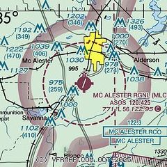
| Sectional chart |
|---|
|
| Airport distance calculator |
|---|
|
|
| Sunrise and sunset |
|---|
|
Times for 03-Jun-2026
| | Local
(UTC-5) | | Zulu
(UTC) |
|---|
| Morning civil twilight | | 05:42 | | 10:42 |
| Sunrise | | 06:11 | | 11:11 |
| Sunset | | 20:31 | | 01:31 |
| Evening civil twilight | | 21:01 | | 02:01 |
|
| Current date and time |
|---|
| Zulu (UTC) | 03-Jun-2026 15:37:35 |
|---|
| Local (UTC-5) | 03-Jun-2026 10:37:35 |
|---|
|
| METAR |
|---|
| KMLC | 031453Z AUTO 12005KT 10SM 26/21 A3017 RMK AO2 SLP206 T02610206 51010
|
|
| TAF |
|---|
| KMLC | 031120Z 0312/0412 VRB04KT P6SM SCT050 BKN100 FM031700 12007KT P6SM SCT050 BKN100 FM040300 15004KT P6SM BKN200
|
|
| NOTAMs |
|---|
NOTAMs are issued by the DoD/FAA and will open in a separate window not controlled by AirNav.
|
|


