FAA INFORMATION EFFECTIVE 14 MAY 2026
Location
| FAA Identifier: | ADH |
| Lat/Long: | 34-48-15.3431N 096-40-16.3191W
34-48.255718N 096-40.271985W
34.8042620,-96.6711997
(estimated) |
| Elevation: | 1015.9 ft. / 309.6 m (surveyed) |
| Variation: | 03E (2020) |
| From city: | 2 miles N of ADA, OK |
| Time zone: | UTC -5 (UTC -6 during Standard Time) |
| Zip code: | 74820 |
Airport Operations
| Airport use: | Open to the public |
| Activation date: | 01/1943 |
| Control tower: | no |
| ARTCC: | FORT WORTH CENTER |
| FSS: | MC ALESTER FLIGHT SERVICE STATION |
| NOTAMs facility: | ADH (NOTAM-D service available) |
| Attendance: | MON-SAT 0800-1700, ALL SUN 1200-1700 |
| Wind indicator: | lighted |
| Segmented circle: | yes |
| Lights: | ACTVT ODALS RWY 18; REILS RWY 36; MIRL RWY 18/36 - CTAF. PAPI RWY 18 & 36 ON CONSLY. |
| Beacon: | white-green (lighted land airport)
Operates sunset to sunrise. |
| Landing fee: | yes, LNDG FEE FOR ACFT 50000 LBS OR GTR. |
Airport Communications
| CTAF/UNICOM: | 122.8 |
| WX AWOS-3PT: | 118.725 (580-332-6222) |
- APCH/DEP CTL SVC PRVDD BY FORT WORTH ARTCC (ZFW) ON FREQS 132.2/338.35 (MC ALESTER RCAG).
Airport Services
| Fuel available: | 100LL JET-A+
100LL:AFT HR FUEL - 580-235-5279. |
| Parking: | hangars and tiedowns |
| Airframe service: | MAJOR |
| Powerplant service: | MAJOR |
| Bulk oxygen: | HIGH/LOW |
Runway Information
Runway 18/36
| Dimensions: | 6203 x 100 ft. / 1891 x 30 m |
| Surface: | asphalt, in fair condition |
| Weight bearing capacity: | | Single wheel: | 50.0 | | Double wheel: | 140.0 | | Double tandem: | 224.0 |
|
| Runway edge lights: | medium intensity |
| RUNWAY 18 | | RUNWAY 36 |
| Latitude: | 34-48.796417N | | 34-47.773983N |
| Longitude: | 096-40.318533W | | 096-40.318400W |
| Elevation: | 1015.9 ft. | | 979.4 ft. |
| Traffic pattern: | left | | left |
| Runway heading: | 177 magnetic, 180 true | | 357 magnetic, 360 true |
| Displaced threshold: | no | | 100 ft. |
| Markings: | nonprecision, in good condition | | nonprecision, in good condition |
| Visual slope indicator: | 4-light PAPI on left (3.00 degrees glide path) | | 4-light PAPI on left (3.00 degrees glide path)
UNUSBL BYD 7 DEGS RIGHT OF CNTRLN. |
| Approach lights: | ODALS: omnidirectional approach lighting system | | |
| Runway end identifier lights: | no | | yes |
| Touchdown point: | yes, no lights | | yes, no lights |
| Obstructions: | 31 ft. trees, 1039 ft. from runway, 54 ft. left of centerline, 27:1 slope to clear
CLNC SLP TO DISP THLD 22:1. | | 62 ft. trees, 1249 ft. from runway, 335 ft. left of centerline, 16:1 slope to clear |
Runway 13/31
| Dimensions: | 2717 x 50 ft. / 828 x 15 m |
| Surface: | asphalt/concrete, in poor condition
SVR CRACKING & RAVELING ASPH PTN. |
| Weight bearing capacity: | | Single wheel: | 50.0 | | Double wheel: | 171.0 | | Double tandem: | 280.0 |
|
| Runway edge markings: | MARKINGS SVRLY FADED. |
| RUNWAY 13 | | RUNWAY 31 |
| Latitude: | 34-48.347067N | | 34-48.029750N |
| Longitude: | 096-40.357478W | | 096-39.974250W |
| Elevation: | 1004.0 ft. | | 978.6 ft. |
| Traffic pattern: | left | | left |
| Runway heading: | 132 magnetic, 135 true | | 312 magnetic, 315 true |
| Markings: | basic, in poor condition | | basic, in poor condition |
| Touchdown point: | yes, no lights | | yes, no lights |
Helipad H1
| Dimensions: | 40 x 40 ft. / 12 x 12 m |
| Surface: | concrete, in excellent condition |
| Runway edge lights: | PERI |
| Latitude: | 34-48.219018N | | |
| Longitude: | 096-40.522887W | | |
| Elevation: | 1002.0 ft. | | |
| Traffic pattern: | left | | left |
| Markings: | NSTD, in good condition | | |
| Touchdown point: | yes, no lights | | no |
Airport Ownership and Management from official FAA records
| Ownership: | Publicly-owned |
| Owner: | CITY OF ADA
231 S TOWNSEND, 512 N. STOCKTON
ADA, OK 74820
Phone 580-436-6300 |
| Manager: | BAILEY KENNEMER
300 RAY STOUT BLVD, SUITE A
ADA, OK 74820
Phone 580-436-8190 |
Additional Remarks
| - | FOR CD CTC FORT WORTH ARTCC AT 817-858-7584. |
Instrument Procedures
NOTE: All procedures below are presented as PDF files. If you need a reader for these files, you should download the free Adobe Reader.NOT FOR NAVIGATION. Please procure official charts for flight.
FAA instrument procedures published for use from 14 May 2026 at 0901Z to 11 June 2026 at 0900Z.
IAPs - Instrument Approach Procedures |
|---|
| RNAV (GPS) RWY 18 | |
download (307KB) |
| RNAV (GPS) RWY 36 | |
download (284KB) |
| NOTE: Special Alternate Minimums apply | |
download |
| NOTE: Special Take-Off Minimums/Departure Procedures apply | |
download (345KB) |
Other nearby airports with instrument procedures:
F99 - Holdenville Municipal Airport (21 nm NE)
KPVJ - Pauls Valley Municipal Airport (28 nm W)
KSRE - Seminole Municipal Airport (28 nm N)
KHMY - Muldrow Army Heliport (31 nm NW)
KADM - Ardmore Municipal Airport (35 nm SW)
|
|

Road maps at:
MapQuest
Bing
Google
| Aerial photo |
|---|
WARNING: Photo may not be current or correct
 Photo by Curtis Brown with Garver.
Photo taken 06-May-2009
from 3500 MSL.
Photo by Curtis Brown with Garver.
Photo taken 06-May-2009
from 3500 MSL.
Do you have a better or more recent aerial photo of Ada Regional Airport that you would like to share? If so, please send us your photo.
|
| Sectional chart |
|---|
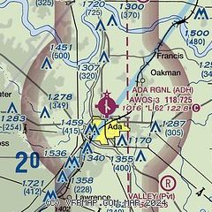
|
| Airport distance calculator |
|---|
|
|
| Sunrise and sunset |
|---|
|
Times for 20-May-2026
| | Local
(UTC-5) | | Zulu
(UTC) |
|---|
| Morning civil twilight | | 05:53 | | 10:53 |
| Sunrise | | 06:21 | | 11:21 |
| Sunset | | 20:25 | | 01:25 |
| Evening civil twilight | | 20:54 | | 01:54 |
|
| Current date and time |
|---|
| Zulu (UTC) | 20-May-2026 13:18:55 |
|---|
| Local (UTC-5) | 20-May-2026 08:18:55 |
|---|
|
| METAR |
|---|
| KADH | 201255Z AUTO 04006KT 2SM BR OVC003 14/14 A3014 RMK AO2 VIS 1 1/2V3
|
|
| TAF |
|---|
KMLC
44nm E | 201120Z 2012/2112 01008KT 3SM BR OVC003 FM201500 01007KT 4SM BR OVC007 FM201800 01006KT P6SM BKN015 FM202200 01006KT P6SM BKN035 FM210600 02003KT 4SM BR OVC015 PROB30 2109/2112 -SHRA
|
KOUN
46nm NW | 201155Z 2012/2112 03010KT 6SM -DZ BR OVC005 FM201600 03009KT P6SM OVC007 FM202000 05008KT P6SM OVC015 FM210600 07006KT P6SM OVC007 PROB30 2106/2112 4SM -TSRA BR OVC007CB
|
|
| NOTAMs |
|---|
NOTAMs are issued by the DoD/FAA and will open in a separate window not controlled by AirNav.
|
|


