FAA INFORMATION EFFECTIVE 16 APRIL 2026
Location
| FAA Identifier: | NBC |
| Lat/Long: | 32-28-50.0408N 080-43-09.2812W
32-28.834013N 080-43.154687W
32.4805669,-80.7192448
(estimated) |
| Elevation: | 37 ft. / 11.3 m (surveyed) |
| Variation: | 05W (1990) |
| From city: | 3 miles NW of BEAUFORT, SC |
| Time zone: | UTC -4 (UTC -5 during Standard Time) |
| Zip code: | 29902 |
Airport Operations
| Airport use: | Private use. Permission required prior to landing |
| Activation date: | 10/1943 |
| Control tower: | yes |
| ARTCC: | JACKSONVILLE CENTER |
| FSS: | ANDERSON FLIGHT SERVICE STATION |
| NOTAMs facility: | NBC (NOTAM-D service available) |
| Attendance: | MON-THU 1200-0400Z++, ALL FRI 1200-2300Z++
CLSD SAT, SUN AND HOL. SPECIAL OPR BY PPR AND NOTAM ONLY. |
| Wind indicator: | yes |
| Segmented circle: | no |
| Lights: | SALSF RWY 05; ALSF-1 RWY 23; PAPI RWY 05, 14, 23 & 32; HIRL RWY 05/23, 14/32 OPR CONSLY. |
| Beacon: | white-white-green (lighted military airport)
Operates sunset to sunrise. |
Airport Communications
| ATIS: | 279.525 |
| BEAUFORT GROUND: | 128.15 348.625 [OPR 1200-0400Z++ MON-THU, 1200-2400Z++ FRI, 2000-2200Z++ SUN, CLSD SAT AND HOL, OT BY NOTAM.] |
| BEAUFORT TOWER: | 119.05 342.875 363.15 [OPR 1200-0400Z++ MON-THU, 1200-2400Z++ FRI, 2000-2200Z++ SUN, CLSD SAT AND HOL, OT BY NOTAM.] |
| BEAUFORT APPROACH: | 123.7 ;3000 FT & BLW 125.125 ;ABV 3000 FT 269.125 ;3000 FT & BLW 292.125 ;ABV 3000 FT [1200-0400Z++ MON-SUN; 1500-2300Z++ HOLS.] |
| BEAUFORT DEPARTURE: | 123.7 ;3000 FT & BLW 125.125 ;ABV 3000 FT 269.125 ;3000 FT & BLW 292.125 ;ABV 3000 FT [1200-0400Z++ MON-SUN; 1500-2300Z++ HOLS.] |
| CLEARANCE DELIVERY: | 128.15 254.375 |
| EMERG: | 121.5 243.0 |
| PMSV METRO: | 264.5 |
| PTD: | 281.8 ;BASE OPS |
| SFA: | 298.875X 317.775X 323.275X 372.0X 379.275X |
| WX AWOS-3 at ARW (6 nm SE): | 119.675 (843-524-1000) |
| WX AWOS-3PT at 3J1 (14 nm W): | 118.450 (843-547-8419) |
| WX AWOS-3PT at HXD (15 nm S): | 121.4 (843-342-5072) |
- APCH/DEP SVC PRVDD BY JACKSONVILLE ARTCC (SAVANNAH RCAG) ON FREQS 132.925/363.2 WHEN BEAUFORT APCH CTL CLSD.
- OPR 1200-0400Z++ MON-THU; 1200-2300Z++ FRI; CLSD SAT SUN & HOL.
Nearby radio navigation aids
| VOR radial/distance | | VOR name | | Freq | | Var |
|---|
| SAVr057/31.5 | | SAVANNAH VORTAC | | 115.95 | | 06W |
| SVNr039/35.3 | | HUNTER VOR/DME | | 111.60 | | 02W |
Airport Services
| Bottled oxygen: | NONE |
| Bulk oxygen: | HIGH/LOW |
Runway Information
Runway 5/23
| Dimensions: | 12202 x 200 ft. / 3719 x 61 m |
| Surface: | PEM |
| Weight bearing capacity: | |
| Runway edge lights: | high intensity |
| RUNWAY 5 | | RUNWAY 23 |
| Latitude: | 32-28.233453N | | 32-29.732232N |
| Longitude: | 080-43.827995W | | 080-42.243732W |
| Elevation: | 36.9 ft. | | 12.9 ft. |
| Traffic pattern: | left | | left |
| Runway heading: | 047 magnetic, 042 true | | 227 magnetic, 222 true |
| Markings: | precision, in good condition | | precision, in good condition |
| Visual slope indicator: | 4-light PAPI on left (3.00 degrees glide path) | | 4-light PAPI on left (3.00 degrees glide path) |
| Approach lights: | SALSF | | ALSF1: standard 2,400 foot high intensity approach lighting system with centerline sequenced flashers (category I) |
| Touchdown point: | yes, no lights | | yes, no lights |
| Instrument approach: | | | ILS/DME |
Runway 14/32
| Dimensions: | 8001 x 200 ft. / 2439 x 61 m |
| Surface: | PEM |
| Weight bearing capacity: | |
| Runway edge lights: | high intensity |
| RUNWAY 14 | | RUNWAY 32 |
| Latitude: | 32-29.075998N | | 32-28.138043N |
| Longitude: | 080-43.883282W | | 080-42.788542W |
| Elevation: | 32.2 ft. | | 23.1 ft. |
| Traffic pattern: | left | | left |
| Runway heading: | 140 magnetic, 135 true | | 320 magnetic, 315 true |
| Markings: | precision, in good condition | | precision, in good condition |
| Visual slope indicator: | 4-light PAPI on left (3.00 degrees glide path) | | 4-light PAPI on left (3.00 degrees glide path) |
| Touchdown point: | yes, no lights | | yes, no lights |
Airport Ownership and Management from official FAA records
| Ownership: | U.S. Navy |
| Owner: | US NAVY
OCEANOGRAPHIC OFC-CODE 3142
WASHINGTON, DC 20373 |
| Manager: | COMMANDING OFFICER
MARINE CORPS AIR STATION
BEAUFORT, SC 29902 |
Additional Remarks
| E60-32 | HOOK E28(B) (1250') |
| E60-05 | HOOK E28(B) (2050') |
| E60-23 | HOOK E28(B) (1900') |
| E60-14 | HOOK E28(B) (1249') |
| - | TRAN ALERT: TRANS SVC AVBL 1200-2300Z++ MON-FRI ONLY, CLSD NATL HOL. (SEE RTSD FOR ADDNL TRAN ACFT INFO) TRAN ACFT EXP TRUCK REFUEL. TRAN ACFT MAINT UNAVBL. TRAN AVN ORDNANCE SVC AVBL. LAVATORY SVC UNAVBL. JASU, FLUID, AND OIL UNAVBL. |
| - | RSTD: RSTD - PPR, 24 HR PN RQR, CTC AFLD BASE OPS DSN 335-7301/7302/7303 C843-228-7301/7302. |
| - | REMARKS: OPR 1200-0400Z++ MON-THU, 1200-2400Z++ FRI, 2000-2200Z++ SUN, CLSD SAT AND HOL, OT BY NOTAM. |
| - | RWY: FIRST 1000 FT ALL RWYS CONC, INTERIOR PORTIONS ASPHALT. VERTICAL LANDING PADS WITH HIGH TEMP CONCR AVBL FOR V/STOL AND R/W ACFT. WT BRG WAIVERS CTC BASE OPS. |
| - | COMMUNICATIONS: SFA REMARKS: AS ASGN. |
| - | CLOSED FIELD OPNS (CFO) ARE RSTRD AND RQR PPR. FOR ANY FURTHER QUESTIONS PLEASE CONTACT MARINE CORPS AIR STATION BEAUFORT AIRFIELD OPERATIONS AT 843-228-7301. |
| - | SEE TERMINAL FLIP FOR RADAR MINIMA. |
| - | SERVICE: A-GEAR - E-28 ON ALL RWY IN RAISED POSITION, EXC ON LDG RWY. |
| - | FUEL: J5 TRANS ALERT - TRANS SVC AVBL 1200-2300Z++ MON-FRI, CLSD HOL. TRANS HOT PIT AVBL BY PPR NO LATER THAN 1 HR PRIOR TO TRANS ALERT CLOSING. NO LCL, ROUND ROBIN TRANS SUP. WEAPONS ARM/DE-ARM SAFEING NOT AVBL. GND SVCG NOT AVBL WHEN LIGHTNING WI 10 NM. QUESTIONS REG SPECIFIC ACFT EQUIP SUP CTC TRANS ALERT DSN 228-7110, C 843-228-7110. |
| - | RSTD: OFFL BUS, PPR ALWAYS, MIN 24 HR NOTICE CTC BASE OPS DSN 335-7301, C 843-228-7301 OR EMAIL: BFRT_BASE_OPERATIONS@USMC.MIL. PN ALL INBD TRAN ACFT TO INCL AMC, JOSAC, ALTN AFLD, AND DIVERTS. PN APVL GOOD FOR +/- 1 HR OF COORD TIME. INBD ACFT WITH VIP, CARGO, PAX CTC BASE OPS VIA PTD 281.8 AT LEAST 20 MINS PRIOR TO LDG. WHEN NEC 180 DEGREE TURNS ON RWY EXECUTE LAST 1000 FT FOR C-130 ACFT AND LARGER. |
| - | CAUTION: RWY 14/32 CONC ENDS WITH NSTD OVRN LEN 200 FT. F-35B SHORT TAKEOFF OR LIMITED TO CONC ENDS OF RWYS. F-35B/AV-8 HOVER LDG RSTD TO VERTICAL LANDING PADS. ACFT RSTD FR TAXIING ON TOWWAY RD BTN RWY 5 AND TEST CELL; TOW ONLY. BIRD, DEER AND COYOTE HAZ. BIRD ACT INCR BTN OCT-APR. HVY AND LARGE 4 ENG ACFT ARE REQ TO IDLE OUTBOARD ENGS ON TWY A/B ADJ TO ACFT PARKING RAMPS DUE TO FOD HAZ. PORTIONS OF ACFT RAMPS NOT VIS FR TWR. UNCTL VEH TFC ON RAMPS. |
| - | TFC PAT: OVERHEAD 1500 FT, CONVL 800 FT, COPTER CALL ENTERING CLASS D AIRSPACE BLW 800 FT. MSTD RSRS APPLIED TO USN/USMC ACFT ONLY. SIMULTANEOUS RUNWAY OPR AND F-35B VSTOL LANDING PADS. |
| - | MISC: DURING SINGLE RWY OPS NON-TENANT ACFT EXP DELAYS. LTD CSTMS/AG AVBL 24 HR PN CTC DSN 335-6161, C 843-228-6161. COMSEC NOT AVBL. INTL GARBAGE CAP UNAVBL. ARFF CAT 3/FAA INDEX D. CLASS D AIRSPACE REVERTS TO CLASS E WHEN TWR CLSD. AFTER HRS URGENT AIRFIELD MATTERS CTC DUTY OFFICER DSN 335-7121, C 843-228-7121. |
Instrument Procedures
NOTE: All procedures below are presented as PDF files. If you need a reader for these files, you should download the free Adobe Reader.NOT FOR NAVIGATION. Please procure official charts for flight.
FAA instrument procedures published for use from 16 April 2026 at 0901Z to 14 May 2026 at 0900Z.
IAPs - Instrument Approach Procedures |
|---|
| ILS OR LOC Y RWY 23 **CHANGED** | |
download (163KB) |
| ILS OR LOC Z RWY 23 **CHANGED** | |
download (165KB) |
| RNAV (GPS) RWY 05 **CHANGED** | |
download (169KB) |
| RNAV (GPS) RWY 14 **CHANGED** | |
download (152KB) |
| RNAV (GPS) RWY 23 **CHANGED** | |
download (162KB) |
| RNAV (GPS) RWY 32 **CHANGED** | |
download (166KB) |
| HI-TACAN X RWY 23 **CHANGED** | |
download (223KB) |
| HI-TACAN Y RWY 14 **CHANGED** | |
download (224KB) |
| HI-TACAN Y RWY 23 **CHANGED** | |
download (225KB) |
| HI-TACAN Z RWY 14 **CHANGED** | |
download (210KB) |
| HI-TACAN Z RWY 23 **CHANGED** | |
download (204KB) |
| TACAN RWY 05 **CHANGED** | |
download (167KB) |
| TACAN RWY 14 **CHANGED** | |
download (167KB) |
| TACAN RWY 23 **CHANGED** | |
download (155KB) |
| TACAN RWY 32 **CHANGED** | |
download (165KB) |
| Radar Approach Procedures available | |
download (162KB) |
| NOTE: Special Take-Off Minimums/Departure Procedures apply | |
download (386KB) |
Other nearby airports with instrument procedures:
KARW - Beaufort Executive Airport (6 nm SE)
KHXD - Hilton Head Airport (15 nm S)
KRBW - Lowcountry Regional Airport (27 nm N)
KSAV - Savannah/Hilton Head International Airport (32 nm SW)
KSVN - Hunter Army Airfield (36 nm SW)
|
|

Road maps at:
MapQuest
Bing
Google
| Aerial photo |
|---|
WARNING: Photo may not be current or correct

Do you have a better or more recent aerial photo of Beaufort Marine Corps Air Station (Merritt Field) Airport that you would like to share? If so, please send us your photo.
|
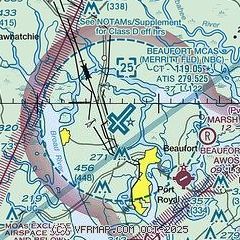
| Sectional chart |
|---|
|
 Download PDF
of official airport diagram from the FAA
| Airport distance calculator |
|---|
|
|
| Sunrise and sunset |
|---|
|
Times for 19-Apr-2026
| | Local
(UTC-4) | | Zulu
(UTC) |
|---|
| Morning civil twilight | | 06:24 | | 10:24 |
| Sunrise | | 06:50 | | 10:50 |
| Sunset | | 19:54 | | 23:54 |
| Evening civil twilight | | 20:20 | | 00:20 |
|
| Current date and time |
|---|
| Zulu (UTC) | 19-Apr-2026 04:02:57 |
|---|
| Local (UTC-4) | 19-Apr-2026 00:02:57 |
|---|
|
| METAR |
|---|
| KNBC | 190356Z AUTO 20007KT 10SM CLR 23/17 A2995 RMK AO2 SLP142 T02280167
|
KHXD
15nm S | 190355Z AUTO 21011KT 10SM CLR 23/16 A2997 RMK AO2
|
|
| TAF |
|---|
| KNBC | 182000Z 1821/1921 17010KT 9999 FEW060 QNH2990INS BECMG 1822/1900 18010G20KT QNH2990INS FM191530 33010G20KT 9999 BKN060 QNH2993INS TX31/1821Z TN13/1911Z
|
|
| NOTAMs |
|---|
NOTAMs are issued by the DoD/FAA and will open in a separate window not controlled by AirNav.
|
|


