FAA INFORMATION EFFECTIVE 22 JANUARY 2026
Location
| FAA Identifier: | SVN |
| Lat/Long: | 32-00-36.0730N 081-08-45.5560W
32-00.601217N 081-08.759267W
32.0100203,-81.1459878
(estimated) |
| Elevation: | 41.3 ft. / 13 m (estimated) |
| Variation: | 04W (1985) |
| From city: | 2 miles SW of SAVANNAH, GA |
| Time zone: | UTC -5 (UTC -4 during Daylight Saving Time) |
| Zip code: | 31405 |
Airport Operations
| Airport use: | Private use. Permission required prior to landing |
| Activation date: | 04/1940 |
| Control tower: | yes |
| ARTCC: | JACKSONVILLE CENTER |
| FSS: | MACON FLIGHT SERVICE STATION |
| NOTAMs facility: | SVN (NOTAM-D service available) |
| Attendance: | CONTINUOUS |
| Segmented circle: | no |
| Lights: | ACTVT ALS RWY 10; 3-STEP ALS RWY 28; REIL RWY 10; PAPI RWY 10 & 28; HIRL RWY 10/28 - CTAF WHEN TWR CLSD. |
| Beacon: | white-white-green (lighted military airport)
Operates sunset to sunrise. |
| International operations: | customs landing rights airport |
Airport Communications
| CTAF: | 124.975 |
| ATIS: | 127.525 323.125 |
| HUNTER GROUND: | 121.8 291.675 [1230Z ++ MON-0400Z ++ SAT, EXC HOL.] |
| HUNTER TOWER: | 124.975 279.575 [1230Z ++ MON-0400Z ++ SAT, EXC HOL.] |
| SAVANNAH APPROACH: | 120.4 125.3 ;011-109 |
| SAVANNAH DEPARTURE: | 120.4 125.3 ;011-109 |
| ARNG OPS: | 36.825 |
| ASR/PAR: | 134.7 317.475 |
| BASE OPS: | 285.425 |
| CG OPS: | 345.0 ;USCG SAVANNAH AIR |
| EMERG: | 121.5 243.0 |
| GCA: | 134.7 307.125 317.475 |
| PMSV METRO: | 309.0 45.0FM |
| PTD: | 126.2 |
| WX ASOS at SAV (8 nm N): | PHONE 912-226-2578 |
- APCH/DEP SVC PRVDD BY JACKSONVILLE ARTCC ON FREQS 132.925/363.2 (SAVANNAH RCAG) WHEN SAVANNAH APCH CTL CLSD.
- WHEN TWR CLSD, CTC ARPT ADVSY SVC ON TWR FREQ. SEE FLIP AP/1 SUPPLEMENTARY ARPT INFO.
- OT CTC SAVANNAH APP 120.40. IF SAVANNAH APP CLSD CTC JACKSONVILLE CENTER 127.65.
- PMSV METRO: FULL SVC 0300-0400Z++ SUN-FRI, EXC HOL. WX SVC AVBL 24/5 INCL HOL.
Nearby radio navigation aids
| VOR radial/distance | | VOR name | | Freq | | Var |
|---|
| SVN at field | | HUNTER VOR/DME | | 111.60 | | 02W |
| SAVr168/8.6 | | SAVANNAH VORTAC | | 115.95 | | 06W |
| NDB name | | Hdg/Dist | | Freq | | Var | | ID |
|---|
| BULLO | | 138/35.8 | | 407 | | 05W | | BZQ | -... --.. --.- |
Airport Services
Runway Information
Runway 10/28
| Dimensions: | 11375 x 197 ft. / 3467 x 60 m |
| Surface: | asphalt |
| Weight bearing capacity: | |
| Runway edge lights: | high intensity |
| RUNWAY 10 | | RUNWAY 28 |
| Latitude: | 32-00.636917N | | 32-00.565517N |
| Longitude: | 081-09.859367W | | 081-07.659167W |
| Elevation: | 17.4 ft. | | 26.5 ft. |
| Traffic pattern: | left | | left |
| Runway heading: | 096 magnetic, 092 true | | 276 magnetic, 272 true |
| Markings: | , in good condition | | , in good condition |
| Visual slope indicator: | 4-light PAPI on right (3.00 degrees glide path) | | 4-light PAPI on left (3.00 degrees glide path) |
| RVR equipment: | touchdown | | rollout |
| Approach lights: | NSTD
US CONFIGN TYPE-B 1500 FT LONG. | | ALSF1: standard 2,400 foot high intensity approach lighting system with centerline sequenced flashers (category I) |
| Runway end identifier lights: | yes | | |
| Touchdown point: | yes, no lights | | yes, no lights |
| Instrument approach: | | | ILS/DME |
Airport Ownership and Management from official FAA records
| Ownership: | U.S. Army |
| Owner: | USAASA ATTN: ATAS-AS
9325 GUNSTON RD, BLDG 1466 SUITE N319
ALEXANDRIA, VA 22060-5582 |
Additional Remarks
| - | JASU: 3(AF M32A-86) 3(DND CE12 EQUIVALENT) 1(DND CE14 EQUIVALENT) 1(AF M32-95). |
| - | FUEL: JET A++. TRAN FUEL PPR, CTC BASE OPS DSN 313-801-8261/60/59, C571-801-8261/60/59. TRAN ACFT MAY EXP DELAY DUE TO OPR MSN. |
| - | OIL: O-156. |
| - | TRAN ALERT: LTD SVC AVBL 1230-0400Z++ MON-SAT, EXC HOL. |
| - | CAUTION: WILDLIFE HAZ. SEAGULL HAZ. |
| - | TFC PAT: F/W 1500 FT, R/W 700 FT. |
| - | MISC: R/W PILOTS PLANNING TO CONDUCT OPR WITHIN R3005 MUST RCV A RNG BRIEFING PRIOR TO OPR. BRIEFING SHALL BE ACCOMPLISHED AT LEAST 4 HR PRIOR TO FLT ON THE RESERVATION. AVIATORS BRIEFED WITHIN THE PAST 6 MONTHS MAY RCV FONE UPDATE. |
| - | MISC: FOR BRIEFING COORD CTC DSN 313-801-8271, C571-801-8271, 1300-2100Z++ MON-FRI EXC HOL. BASE OPS OPR 24/5, 1200Z++ MON-0400Z++ SAT, EXC HOL. WX OBSERVER OPR 1230Z++ MON-0400Z++ SAT, EXE HOL. OT, EXCLD HOL. NO EMERG SVC AVBL WHEN TWR AND BASE OPS CLSD. |
| - | SEE FLIP AP/1 SUPPLEMENTARY ARPT RMK. |
| - | CAUTION: TAXIWAY 7E/W CLSD. NO R/W HOVERING ON WEST RAMP WITHOUT PRIOR PERMISSION. |
| - | ARNGOPS CTC DSN 729-7182/6534, C912-315-7182/6534. |
| - | RSTD: AFLD CLSD 0400Z++ SAT THRU 1230Z++ MON TO TRAN F/W ACFT EXC FOR OFFL BUS ONLY. PPR FOR ALL TRAN ACFT TO INCL TOUCH AND GO OPS, CTC BASE OPS DSN 313-801-8259/60/61, C571-801-8261/60/59. |
| - | MISC: FULL WX SVC OPR 24/5, 0300Z++MON-0400Z++ SAT, EXC HOL, DSN 313-801-8263/64, C571-801-8263/64. OT REMOTE BRIEFING FR 26 OWS BARKSDALE AFB, LA, DSN 331-2651/2/3, C318-529-2651/2/3. PRIM WX SENSORS IN USE AN/FMQ-19 AUTOMATED FULL TIME AND AUGMENT AS RQR. DUR PERIODS OF AUGMENT, ATC WILL ASSIST IN COOPERATIVE WATCH BY NOTIFYING WX OF UNREPORTED WX COND. AUGMENTATION/BACK-UP MODE, PREVAIL SFC VIS MAY NOT REPRESENT ENTIRE AFLD, FR 280 - 090 DEGS DUE TO BLDG OBST AND LACK OF VIS MARK BYD 1/4 SM. PMSV AVBL DUR OPR HR. |
| - | COMPASS ROSE CALIBRATION OTS. |
| - | ARNG: BASE OPS CTC DSN 729-7182/6534, C912-315-7182/6534. |
| - | NS ABTMT: PROCEDURES IN EFFECT 0300Z-1200Z++ MON-SAT; 0300Z-1800Z++ SUN. PRACTICE MULTIPLE CIRCLING APCH CAT C, D, E NOT AUTH BLW 1500 FT. NO OVFT OF SAVANNAH AND SUR POPULATED AREAS BLW 1000 FT UNLESS ON APCH TO HUNTER AAF. QUIET HR 0230-1030Z++. |
Instrument Procedures
NOTE: All procedures below are presented as PDF files. If you need a reader for these files, you should download the free Adobe Reader.NOT FOR NAVIGATION. Please procure official charts for flight.
FAA instrument procedures published for use from 22 January 2026 at 0901Z to 19 February 2026 at 0900z.
IAPs - Instrument Approach Procedures |
|---|
| ILS OR LOC RWY 28 | |
download (179KB) |
| RNAV (GPS) RWY 10 | |
download (153KB) |
| RNAV (GPS) RWY 28 | |
download (170KB) |
| VOR/DME RWY 28 | |
download (157KB) |
| COPTER VOR RWY 10 | |
download (112KB) |
| NOTE: Special Take-Off Minimums/Departure Procedures apply | |
download (499KB) |
Other nearby airports with instrument procedures:
KSAV - Savannah/Hilton Head International Airport (8 nm N)
KLHW - Wright Army Airfield (Fort Stewart)/Midcoast Regional Airport (22 nm W)
KHXD - Hilton Head Airport (26 nm NE)
KARW - Beaufort Executive Airport (35 nm NE)
KNBC - Beaufort Marine Corps Air Station (Merritt Field) Airport (36 nm NE)
|
|

Road maps at:
MapQuest
Bing
Google
| Aerial photo |
|---|
WARNING: Photo may not be current or correct
 Photo taken 24-Dec-2005
from 2,500 ft
Photo taken 24-Dec-2005
from 2,500 ft
Do you have a better or more recent aerial photo of Hunter Army Airfield that you would like to share? If so, please send us your photo.
|
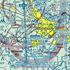
| Sectional chart |
|---|
|
 Download PDF
of official airport diagram from the FAA
| Airport distance calculator |
|---|
|
|
| Sunrise and sunset |
|---|
|
Times for 02-Feb-2026
| | Local
(UTC-5) | | Zulu
(UTC) |
|---|
| Morning civil twilight | | 06:53 | | 11:53 |
| Sunrise | | 07:19 | | 12:19 |
| Sunset | | 17:58 | | 22:58 |
| Evening civil twilight | | 18:24 | | 23:24 |
|
| Current date and time |
|---|
| Zulu (UTC) | 02-Feb-2026 21:35:28 |
|---|
| Local (UTC-5) | 02-Feb-2026 16:35:28 |
|---|
|
| METAR |
|---|
| KSVN | 021855Z AUTO 29009KT 10SM CLR 09/M13 A3026 RMK AO2 SLP251 T00931132 $
|
KSAV
7nm NW | 022053Z 28009KT 10SM CLR 11/M12 A3028 RMK AO2 SLP252 T01061122 56021
|
|
| TAF |
|---|
| KSVN | 021700Z 0217/0323 04006KT 9999 SKC QNH3032INS BECMG 0222/0223 29006KT 9999 SKC QNH3032INS TX10/0220Z TNM03/0309Z
|
KSAV
7nm NW | 021720Z 0218/0318 28008KT P6SM SKC FM030000 00000KT P6SM SKC FM031200 24005KT P6SM SKC
|
|
| NOTAMs |
|---|
NOTAMs are issued by the DoD/FAA and will open in a separate window not controlled by AirNav.
|
|


