FAA INFORMATION EFFECTIVE 16 APRIL 2026
Location
| FAA Identifier: | NXP |
| Lat/Long: | 34-17-45.9975N 116-09-43.5425W
34-17.766625N 116-09.725708W
34.2961104,-116.1620951
(estimated) |
| Elevation: | 2051.1 ft. / 625 m (estimated) |
| Variation: | 11E (2025) |
| From city: | 9 miles NW of TWENTYNINE PALMS, CA |
| Time zone: | UTC -7 (UTC -8 during Standard Time) |
| Zip code: | 92278 |
Airport Operations
| Airport use: | Private use. Permission required prior to landing |
| Activation date: | 10/1976 |
| Control tower: | no |
| ARTCC: | LOS ANGELES CENTER |
| FSS: | RIVERSIDE FLIGHT SERVICE STATION |
| NOTAMs facility: | NXP (NOTAM-D service available) |
| Attendance: | ALL
OPR HRS IAW PUBL NOTAMS FOR EXER SPT AND PPRS ONLY. SEE FLIP AP/1 SUPPLEMENTARY ARPT RMK. |
| Pattern altitude: | TFC PAT #1 OF 2: ALL TFC PAT S OF RWY DUE TO LIVE FIRE RANGE IMMEDIATELY N OF SELF. |
| Wind indicator: | yes |
| Segmented circle: | no |
| Lights: | ALL LGTG BY PRIOR APVL. |
| Beacon: | white-green (lighted land airport)
ALL LGTG BY PRIOR APVL. |
Airport Communications
| WX ASOS: | 309.75 (760-830-8146) |
Nearby radio navigation aids
| VOR radial/distance | | VOR name | | Freq | | Var |
|---|
| TNPr285/22.4 | | TWENTYNINE PALMS VORTAC | | 114.20 | | 15E |
| PSPr014/28.8 | | PALM SPRINGS VORTAC | | 115.50 | | 13E |
| HECr139/33.5 | | HECTOR VORTAC | | 112.70 | | 15E |
Airport Services
Runway Information
Runway 10/28
| Dimensions: | 8015 x 150 ft. / 2443 x 46 m |
| Surface: | pierced steel planking |
| Weight bearing capacity: | | Single wheel: | 80.0 | | Double wheel: | 180.0, TWO SINGLE TANDEM WHEELS 175 | | Double tandem: | 320.0 | | Dual double tandem: | 850.0, TWO TRIPLE WHEELS IN TANDEM TYPE LANDING GEAR 520 |
|
| Runway edge lights: | high intensity |
| RUNWAY 10 | | RUNWAY 28 |
| Latitude: | 34-18.017350N | | 34-17.515900N |
| Longitude: | 116-10.462267W | | 116-08.989150W |
| Elevation: | 2051.1 ft. | | 2017.7 ft. |
| Traffic pattern: | right | | left |
| Approach lights: | SALSF
OLS | | SALSF
OLS |
| Runway end identifier lights: | no | | no |
| Touchdown point: | yes, no lights | | yes, no lights |
Airport Ownership and Management from official FAA records
| Ownership: | U.S. Navy |
| Owner: | US NAVY
OCEANOGRAPHIC OFC CODE 3142
WASHINGTON, DC 20373 |
Additional Remarks
| - | RSTD: CLSD FLD OPR PERM BY PN APVL EXC MCAGCC SAR ACFT. PPR REQ FOR FUEL, VIP/PAX MOVEMENT, PRACTICE ARRESTMENTS, AND NVD TRNG. OPR OUTSIDE PUBL HR PERMS 24 HR PPR AND 72 HR PPR SAT AND SUN. BASE OPS DSN 230-7815,C760-830-7815. |
| - | LGT: ALL LGT BY PRIOR APVL. |
| - | A-GEAR: RWY 10, HOOK M31(B) (1987'); RWY 28, HOOK M31(B) (1565'); CTC TWR FOR ARRESTMENT, EXP 5 MIN DELAY. |
| - | FUEL: QUALIFIED ACFT CAPTAIN/CREW CHIEF MUST BE PROVIDED BY USER TO REFUL ACFT. J8. |
| - | TRAN ALERT: NO AMC FLEET SVC AVBL. ALL VIP ACFT CTC AIRFIELD OPS FOR PPR 24 HOURS PRIOR TO ARR. |
| - | CAUTION: HELICOPTER LZ (HLZ) WHITE RHINO (UAS STRIP 2000' X 72') S OF AND PARALLEL TO RWY 28 IS PRIM FOR TENANT UAS SUPPORT, RSTD TO UAS AND COPTER OPS ONLY; NO TILTROTOR OPS AUTH. MRKD WITH 72' X 72' HELO SPOTS ON E AND W END. 17' AGL HGR LCTD 120 FT S OF LZ CNTRLN. |
| - | CAUTION: RYS HAVE AM-2 RY SFC MATTING. THIS IS FABRICATED ALUMINUM PANEL 1.5" THICK, WHICH CONSISTS OF HOLLOW, EXTRUDED, ONE-PIECE MAIN SEC WITH EXTRUDED END CONNECTORS WELDED TO EA END. THE TOP SFC OF AM-2 MATTING IS COATED WITH A NON-SKID MATERIAL. |
| - | CAUTION: THE TOP SFC OF AM-2 MATTING IS COATED WITH A NON-SKID MATERIAL. WT BRG CHARACTERISTICS ARE CORRECTLY NOTED BY THE AVBL RWY CODE ABV TRT520. |
| - | TFC PAT: ALL TFC PAT S OF RWY DUE TO LIVE FIRE RANGE IMMEDIATELY N OF SELF. REMAIN ON OR S OF EXTN RWY CNTRLINE ON FINAL APCH. VFR F/W TO RWY 28 MAINTAIN AT OR ABV 4100' MSL UNTIL NXP 5 DME. VFR F/W DEPARTURES RWY10 CROSS NXP 5 DME AT OR ABV 4100' MSL OR RIGHT TURN TO BANDINI (WATER TREATMENT FACILITY 6 NM SE). |
| - | BEARING STRENGTH RWY 10/28: S80 T180 ST175 TT320 TDT850 TRT520. |
| - | MISC: CLASS D AIRSPACE EFF NOTAM ONLY, OT CLASS G. |
| - | 500 FT BY 490 FT AM-2 MATTING ON WEST END F/W RAMP. |
| - | WHEN ATCT CLSD, FOR CD CTC LOS ANGELES ARTCC AT 661-575-2079. |
| - | RSTD: AUSTERE/ DESERT TRNG ENVIRONMENT PRIM FOR SUPPORT OF CAX. VARIABLE HR YR ROUND AS REQ BY CAX COMD ELEMENT. IF TWENTYNINE PALMS SELF IS FINAL DESTN, ENSURE NXP IS FILED, NOT TNP. |
Instrument Procedures
There are no published instrument procedures at KNXP.
Some nearby airports with instrument procedures:
KTNP - Twentynine Palms Airport (15 nm SE)
KPSP - Palm Springs International Airport (33 nm SW)
KUDD - Bermuda Dunes Airport (33 nm S)
L35 - Big Bear City Airport (34 nm W)
KTRM - Jacqueline Cochran Regional Airport (40 nm S)
|
|

Road maps at:
MapQuest
Bing
Google
| Aerial photo |
|---|
WARNING: Photo may not be current or correct
 Photo by Michael House
Photo taken 23-May-2009
Photo by Michael House
Photo taken 23-May-2009
Do you have a better or more recent aerial photo of Twentynine Palms SELF Airport that you would like to share? If so, please send us your photo.
|
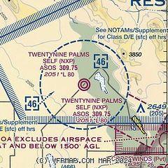
| Sectional chart |
|---|
|
 Download PDF
of official airport diagram from the FAA
| Airport distance calculator |
|---|
|
|
| Sunrise and sunset |
|---|
|
Times for 13-May-2026
| | Local
(UTC-7) | | Zulu
(UTC) |
|---|
| Morning civil twilight | | 05:17 | | 12:17 |
| Sunrise | | 05:45 | | 12:45 |
| Sunset | | 19:37 | | 02:37 |
| Evening civil twilight | | 20:05 | | 03:05 |
|
| Current date and time |
|---|
| Zulu (UTC) | 14-May-2026 02:01:31 |
|---|
| Local (UTC-7) | 13-May-2026 19:01:31 |
|---|
|
| METAR |
|---|
| KNXP | 140154Z AUTO 23013G22KT 10SM 30/01 A2993 RMK AO2 SLP100 T03000011 $
|
|
| TAF |
|---|
| KNXP | 132100Z 1321/1421 21012G22KT 9999 SKC QNH2998INS FM132300 25016G26KT 9999 SKC QNH2998INS FM140500 33008KT 9999 SKC QNH3003INS TX33/1321Z TN21/1411Z
|
|
| NOTAMs |
|---|
NOTAMs are issued by the DoD/FAA and will open in a separate window not controlled by AirNav.
|
|


