FAA INFORMATION EFFECTIVE 14 MAY 2026
Location
| FAA Identifier: | ODX |
| Lat/Long: | 41-37-25.3000N 098-57-06.7000W
41-37.421667N 098-57.111667W
41.6236944,-98.9518611
(estimated) |
| Elevation: | 2070 ft. / 630.9 m (surveyed) |
| Variation: | 05E (2010) |
| From city: | 2 miles NW of ORD, NE |
| Time zone: | UTC -5 (UTC -6 during Standard Time) |
| Zip code: | 68862 |
Airport Operations
| Airport use: | Open to the public |
| Activation date: | 01/1947 |
| Control tower: | no |
| ARTCC: | MINNEAPOLIS CENTER |
| FSS: | COLUMBUS FLIGHT SERVICE STATION |
| NOTAMs facility: | ODX (NOTAM-D service available) |
| Attendance: | 0800-1700
FOR SVCS AFTER HRS AMGR. |
| Wind indicator: | lighted |
| Segmented circle: | yes |
| Lights: | ACTVT REIL RWY 13 & 31; PAPI RWY 13 & 31; MIRL RWY 13/31 - CTAF. |
| Beacon: | white-green (lighted land airport)
Operates sunset to sunrise. |
Airport Communications
| CTAF/UNICOM: | 122.8 |
| WX ASOS: | 119.925 (308-728-7954) |
- APCH/DEP SVC PRVDD BY MINNEAPOLIS ARTCC ON FREQS 119.4/278.8 (HASTINGS RCAG).
Nearby radio navigation aids
| VOR radial/distance | | VOR name | | Freq | | Var |
|---|
| CUZr068/34.1 | | CUSTER COUNTY VOR/DME | | 108.20 | | 08E |
| NDB name | | Hdg/Dist | | Freq | | Var | | ID |
|---|
| ORD | | at field | | 356 | | 05E | | ODX | --- -.. -..- |
Airport Services
| Fuel available: | 100LL
100LL:SELF SVC FUEL AVBL H24 HR VIA CREDIT CARD. |
| Parking: | hangars and tiedowns |
| Bottled oxygen: | NONE |
| Bulk oxygen: | NONE |
Runway Information
Runway 13/31
| Dimensions: | 4721 x 75 ft. / 1439 x 23 m |
| Surface: | concrete, in good condition |
| Weight bearing capacity: | |
| Runway edge lights: | medium intensity |
| RUNWAY 13 | | RUNWAY 31 |
| Latitude: | 41-37.746235N | | 41-37.187375N |
| Longitude: | 098-57.519732W | | 098-56.799857W |
| Elevation: | 2070.0 ft. | | 2059.0 ft. |
| Traffic pattern: | left | | left |
| Runway heading: | 131 magnetic, 136 true | | 311 magnetic, 316 true |
| Displaced threshold: | no | | 220 ft. |
| Markings: | nonprecision, in good condition | | nonprecision, in good condition |
| Visual slope indicator: | 2-light PAPI on left (3.00 degrees glide path) | | 2-light PAPI on left (3.00 degrees glide path) |
| Runway end identifier lights: | yes | | yes |
| Touchdown point: | yes, no lights | | yes, no lights |
| Obstructions: | none
4 FT FENCE 237 FT RIGHT. | | 34 ft. pole, 797 ft. from runway, 308 ft. right of centerline, 17:1 slope to clear |
Runway 17/35
| Dimensions: | 2012 x 218 ft. / 613 x 66 m |
| Surface: | turf, in fair condition |
| RUNWAY 17 | | RUNWAY 35 |
| Latitude: | 41-37.479447N | | 41-37.148283N |
| Longitude: | 098-57.003197W | | 098-56.997690W |
| Elevation: | 2059.7 ft. | | 2059.6 ft. |
| Traffic pattern: | left | | left |
| Runway heading: | 174 magnetic, 179 true | | 354 magnetic, 359 true |
| Touchdown point: | yes, no lights | | yes, no lights |
Airport Ownership and Management from official FAA records
| Ownership: | Publicly-owned |
| Owner: | VALLEY COUNTY AIRPORT AUTHORITY
81385 HIGHWAY 11
ORD, NE 68862-5354
Phone (308) 750-5126
DON VANCURA, CHMN ARPT AUTH. |
| Manager: | DAVE WILLIAMS
81385 HIGHWAY 11
ORD, NE 68862-5354
Phone 308-750-5126 |
Additional Remarks
| - | FOR CD CTC MINNEAPOLIS ARTCC AT 651-463-5588. |
| A52-35 | DURING CROP SEASON CORN AT 120' MAKES APCH RATIO 15-1. |
Instrument Procedures
NOTE: All procedures below are presented as PDF files. If you need a reader for these files, you should download the free Adobe Reader.NOT FOR NAVIGATION. Please procure official charts for flight.
FAA instrument procedures published for use from 14 May 2026 at 0901Z to 11 June 2026 at 0900Z.
IAPs - Instrument Approach Procedures |
|---|
| RNAV (GPS) RWY 13 | |
download (221KB) |
| RNAV (GPS) RWY 31 | |
download (235KB) |
| NOTE: Special Alternate Minimums apply **CHANGED** | |
download (147KB) |
| NOTE: Special Take-Off Minimums/Departure Procedures apply | |
download (351KB) |
Other nearby airports with instrument procedures:
KBUB - Cram Field Airport (13 nm NW)
0F4 - Loup City Municipal Airport (20 nm S)
KBBW - Broken Bow Municipal Airport/Keith Glaze Field (33 nm W)
KBVN - Albion Municipal Airport (41 nm E)
KGRI - Central Nebraska Regional Airport (49 nm SE)
|
|

Road maps at:
MapQuest
Bing
Google
| Aerial photo |
|---|
WARNING: Photo may not be current or correct
 Photo by P.J. Reinders
Taken in September 2008
runway 31
Photo by P.J. Reinders
Taken in September 2008
runway 31
Do you have a better or more recent aerial photo of Evelyn Sharp Field Airport that you would like to share? If so, please send us your photo.
|
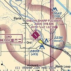
| Sectional chart |
|---|
|
| Airport distance calculator |
|---|
|
|
| Sunrise and sunset |
|---|
|
Times for 06-Jun-2026
| | Local
(UTC-5) | | Zulu
(UTC) |
|---|
| Morning civil twilight | | 05:29 | | 10:29 |
| Sunrise | | 06:03 | | 11:03 |
| Sunset | | 21:06 | | 02:06 |
| Evening civil twilight | | 21:40 | | 02:40 |
|
| Current date and time |
|---|
| Zulu (UTC) | 07-Jun-2026 00:21:05 |
|---|
| Local (UTC-5) | 06-Jun-2026 19:21:05 |
|---|
|
| METAR |
|---|
| KODX | 062353Z AUTO 13012G21KT 10SM CLR 29/18 A2977 RMK AO2 SLP069 T02940183 10300 20261 56014 $
|
|
| TAF |
|---|
KGRI
49nm SE | 061742Z 0618/0718 16008KT P6SM SCT100 SCT200 FM062000 15012G20KT P6SM SCT050 BKN200 FM070100 16010KT P6SM FEW050 BKN150 FM071200 17007KT P6SM OVC050 PROB30 0712/0718 5SM -TSRA BKN030CB
|
|
| NOTAMs |
|---|
NOTAMs are issued by the DoD/FAA and will open in a separate window not controlled by AirNav.
|
|

