FAA INFORMATION EFFECTIVE 14 MAY 2026
Location
| FAA Identifier: | OJA |
| Lat/Long: | 35-32-44.9000N 098-40-06.6000W
35-32.748333N 098-40.110000W
35.5458056,-98.6685000
(estimated) |
| Elevation: | 1605.3 ft. / 489.3 m (surveyed) |
| Variation: | 06E (2005) |
| From city: | 2 miles NE of WEATHERFORD, OK |
| Time zone: | UTC -5 (UTC -6 during Standard Time) |
| Zip code: | 73096 |
Airport Operations
| Airport use: | Open to the public |
| Activation date: | 11/1969 |
| Control tower: | no |
| ARTCC: | FORT WORTH CENTER |
| FSS: | MC ALESTER FLIGHT SERVICE STATION |
| NOTAMs facility: | MLC (NOTAM-D service available) |
| Attendance: | MON-FRI 0800-1730, ALL SAT 0800-1700, ALL SUN 1200-1700 |
| Wind indicator: | lighted |
| Segmented circle: | no |
| Lights: | REIL RWY 17 & 35; MIRL RWY 17/35 ON SS-SR; INCR INTST - CTAF. PAPI RWY 17 & 35 ON CONSLY. |
| Beacon: | white-green (lighted land airport)
Operates sunset to sunrise. |
Airport Communications
| CTAF/UNICOM: | 122.8 |
| WX AWOS-3PT: | 118.575 (580-772-7020) |
| WX AWOS-3 at CLK (13 nm W): | 119.225 (580-323-8477) |
- APCH/DEP CTL SVC PRVDD BY FORT WORTH ARTCC (ZFW) ON FREQS 128.4/269.375 (CLINTON-SHERMAN RCAG).
Nearby radio navigation aids
| VOR radial/distance | | VOR name | | Freq | | Var |
|---|
| BFVr050/32.2 | | BURNS FLAT VORTAC | | 110.00 | | 05E |
Airport Services
| Fuel available: | 100LL JET-A+ |
| Parking: | hangars and tiedowns |
| Airframe service: | MAJOR |
| Powerplant service: | MAJOR |
| Bottled oxygen: | HIGH/LOW |
| Bulk oxygen: | NONE |
Runway Information
Runway 17/35
| Dimensions: | 5100 x 75 ft. / 1554 x 23 m |
| Surface: | concrete, in good condition |
| Weight bearing capacity: | | Single wheel: | 30.0 | | Double wheel: | 48.0 |
|
| Runway edge lights: | medium intensity |
| RUNWAY 17 | | RUNWAY 35 |
| Latitude: | 35-33.168147N | | 35-32.327515N |
| Longitude: | 098-40.111470W | | 098-40.109318W |
| Elevation: | 1599.6 ft. | | 1598.8 ft. |
| Traffic pattern: | left | | left |
| Runway heading: | 174 magnetic, 180 true | | 354 magnetic, 360 true |
| Markings: | nonprecision, in good condition | | nonprecision, in good condition |
| Visual slope indicator: | 2-light PAPI on left (3.34 degrees glide path) | | 2-light PAPI on left (2.92 degrees glide path) |
| Runway end identifier lights: | yes | | yes |
| Touchdown point: | yes, no lights | | yes, no lights |
| Obstructions: | 42 ft. trees, 851 ft. from runway, 165 ft. right of centerline, 15:1 slope to clear
INSTA HWY 844 FT FM RWY 35 END BOTH SIDES CREATES 21:1 OBS-CLNC SLP. | | 49 ft. pline, marked and lighted, 1090 ft. from runway, 18:1 slope to clear |
Airport Ownership and Management from official FAA records
| Ownership: | Publicly-owned |
| Owner: | CITY OF WEATHERFORD
522 W. RAINEY, P. O. BOX 569
WEATHERFORD, OK 73096
Phone 580-772-7451 |
| Manager: | MARK SCHOONMAKER
3000 LOGAN ROAD
WEATHERFORD, OK 73096
Phone 580-774-1971 |
Additional Remarks
| - | FOR CD CTC FORT WORTH ARTCC AT 817-858-7584. |
| - | FBO CLSD SOME HOLS. |
Instrument Procedures
NOTE: All procedures below are presented as PDF files. If you need a reader for these files, you should download the free Adobe Reader.NOT FOR NAVIGATION. Please procure official charts for flight.
FAA instrument procedures published for use from 14 May 2026 at 0901Z to 11 June 2026 at 0900Z.
IAPs - Instrument Approach Procedures |
|---|
| RNAV (GPS) RWY 17 | |
download (207KB) |
| RNAV (GPS) RWY 35 | |
download (240KB) |
| NOTE: Special Alternate Minimums apply | |
download (123KB) |
| NOTE: Special Take-Off Minimums/Departure Procedures apply | |
download (391KB) |
Other nearby airports with instrument procedures:
1O4 - Thomas Municipal Airport (12 nm N)
KCLK - Clinton Regional Airport (13 nm W)
2O8 - Hinton Municipal Airport (16 nm E)
KJWG - Watonga Regional Airport (23 nm NE)
KCSM - Clinton/Sherman Airport (29 nm SW)
|
|

Road maps at:
MapQuest
Bing
Google
| Aerial photo |
|---|
WARNING: Photo may not be current or correct
 Photo taken 22-Feb-2012
looking west.
Photo taken 22-Feb-2012
looking west.
Do you have a better or more recent aerial photo of Weatherford Stafford Airport that you would like to share? If so, please send us your photo.
|
| Sectional chart |
|---|
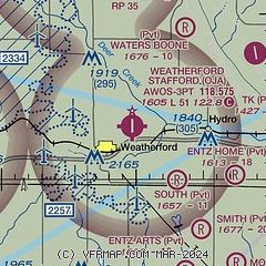
|
| Airport distance calculator |
|---|
|
|
| Sunrise and sunset |
|---|
|
Times for 06-Jun-2026
| | Local
(UTC-5) | | Zulu
(UTC) |
|---|
| Morning civil twilight | | 05:50 | | 10:50 |
| Sunrise | | 06:20 | | 11:20 |
| Sunset | | 20:46 | | 01:46 |
| Evening civil twilight | | 21:16 | | 02:16 |
|
| Current date and time |
|---|
| Zulu (UTC) | 06-Jun-2026 15:28:27 |
|---|
| Local (UTC-5) | 06-Jun-2026 10:28:27 |
|---|
|
| METAR |
|---|
| KOJA | 061510Z AUTO 07004KT 10SM SCT008 BKN012 OVC028 21/20 A2989 RMK AO2 T02070199
|
KCLK
13nm W | 061515Z AUTO 34006KT 7SM RA BKN008 OVC014 20/20 A2991 RMK AO2 P0001
|
|
| TAF |
|---|
KCSM
29nm SW | 061414Z 0614/0712 VRB04KT P6SM FEW008 BKN060 OVC080 TEMPO 0614/0616 5SM -RA FM061600 VRB04KT P6SM BKN012 TEMPO 0616/0620 -TSRA OVC012CB FM062000 15009KT P6SM BKN050 PROB30 0620/0702 4SM TSRA BR OVC025CB FM070200 13010KT P6SM BKN070 PROB30 0702/0708 5SM -SHRA BR OVC025
|
|
| NOTAMs |
|---|
NOTAMs are issued by the DoD/FAA and will open in a separate window not controlled by AirNav.
|
|


