FAA INFORMATION EFFECTIVE 14 MAY 2026
Location
| FAA Identifier: | CSM |
| Lat/Long: | 35-20-23.4210N 099-12-01.7980W
35-20.390350N 099-12.029967W
35.3398392,-99.2004994
(estimated) |
| Elevation: | 1922.1 ft. / 585.9 m (surveyed) |
| Variation: | 05E (2020) |
| From city: | 2 miles SW of BURNS FLAT, OK |
| Time zone: | UTC -5 (UTC -6 during Standard Time) |
| Zip code: | 73641 |
Airport Operations
| Airport use: | Open to the public |
| Activation date: | 10/1971 |
| Control tower: | yes |
| ARTCC: | FORT WORTH CENTER |
| FSS: | MC ALESTER FLIGHT SERVICE STATION |
| NOTAMs facility: | CSM (NOTAM-D service available) |
| Attendance: | MON-FRI 0800-1700
ATCT CLSD FED HOL. |
| Wind indicator: | lighted |
| Segmented circle: | no |
| Lights: | ACTVT REIL RWY 17R & 35L; HIRL RWY 17R/35L; TWY LGT; WDI LGT - CTAF. PAPI RWY 17R & 35L ON CONSLY. |
| Beacon: | white-green (lighted land airport)
Operates sunset to sunrise. |
| Landing fee: | yes, LDG FEE FOR ACFT GTR THAN 50,000 LBS. |
Airport Communications
| CTAF: | 119.6 |
| UNICOM: | 122.95 |
| WX ASOS: | 118.450 (580-562-4811) |
| CLINTON-SHERMAN GROUND: | 121.7 239.0 [0900-0100 MON-FRI ; EXCEPT FEDERAL HOL.] |
| CLINTON-SHERMAN TOWER: | 119.6 256.9 [0900-0100 MON-FRI ; EXCEPT FEDERAL HOL.] |
| EMERG: | 121.5 243.0 |
| WX AWOS-3 at ELK (11 nm NW): | 118.225 (580-303-9147) |
| WX AWOS-3 at CLK (18 nm NE): | 119.225 (580-323-8477) |
- APCH/DEP CTL SVC PRVDD BY FORT WORTH ARTCC (ZFW) ON FREQS 128.4/269.375 (CLINTON-SHERMAN RCAG).
Nearby radio navigation aids
| VOR radial/distance | | VOR name | | Freq | | Var |
|---|
| BFVr358/6.2 | | BURNS FLAT VORTAC | | 110.00 | | 05E |
| HBRr337/29.2 | | HOBART VORTAC | | 115.85 | | 10E |
Airport Services
| Fuel available: | A1+
A1+:24 HR JET-A1+ FUEL & OTR SVC AVBL - CTC 405-267-4010. |
| Parking: | hangars |
| Airframe service: | NONE |
| Powerplant service: | NONE |
| Bottled oxygen: | HIGH |
| Bulk oxygen: | NONE |
Runway Information
Runway 17R/35L
| Dimensions: | 13503 x 200 ft. / 4116 x 61 m |
| Surface: | concrete, in good condition |
| Weight bearing capacity: | | Single wheel: | 50.0 | | Double wheel: | 200.0 | | Double tandem: | 390.0 |
|
| Runway edge lights: | high intensity
NSTD; 75 FT FM RWY EDGE. |
| RUNWAY 17R | | RUNWAY 35L |
| Latitude: | 35-21.579683N | | 35-19.354033N |
| Longitude: | 099-12.086433W | | 099-12.090533W |
| Elevation: | 1922.1 ft. | | 1911.8 ft. |
| Traffic pattern: | right | | left |
| Runway heading: | 175 magnetic, 180 true | | 355 magnetic, 000 true |
| Markings: | precision, in good condition | | precision, in good condition |
| Visual slope indicator: | 4-light PAPI on left (3.00 degrees glide path) | | 4-light PAPI on left (3.00 degrees glide path) |
| Runway end identifier lights: | yes | | yes |
| Touchdown point: | yes, no lights | | yes, no lights |
| Instrument approach: | ILS | | |
Runway 17L/35R
| Dimensions: | 5193 x 75 ft. / 1583 x 23 m |
| Surface: | concrete, in good condition |
| Weight bearing capacity: | | Single wheel: | 50.0 | | Double wheel: | 200.0 | | Double tandem: | 390.0 |
|
| Operational restrictions: | DALGT VFR ONLY. |
| RUNWAY 17L | | RUNWAY 35R |
| Latitude: | 35-20.619350N | | 35-19.763450N |
| Longitude: | 099-11.876983W | | 099-11.878567W |
| Elevation: | 1906.2 ft. | | 1906.8 ft. |
| Traffic pattern: | left | | right |
| Runway heading: | 175 magnetic, 180 true | | 355 magnetic, 000 true |
| Markings: | basic, in good condition | | basic, in good condition |
| Touchdown point: | yes, no lights | | yes, no lights |
Airport Ownership and Management from official FAA records
| Ownership: | Publicly-owned |
| Owner: | OSIDA/STATE OF OKLAHOMA
BOX 689
BURNS FLAT, OK 73624
Phone 580-562-3500 |
| Manager: | JOE CALLAHAN
121 1ST STREET, BOX 689
BURNS FLAT, OK 73624
Phone 580-562-3500 |
Additional Remarks
| - | MIL JET TRNG: HVY JETS SFC TO 5000 FT WI 25 NMR. EXTSV STUDENT PILOT TRNG FM SFC TO 5000 FT WI 10 NMR BTN 0900-1200. |
| - | RWY 17L/35R LAID OUT & MRKD ON RWY 17L/35R PARL TWY. |
| - | MIL JET NGT VISION TRNG: CTC ATCT 10 MINS PRIOR TO LDG AFT SS TO ADJUST ARPT LGTS. |
| - | VFR ACFT ADZD TO CTC ATC 15 NM OUT FOR SEQG. |
| - | MIL ARFF AVBL EXCP WKNDS AND FED HOL. |
Instrument Procedures
NOTE: All procedures below are presented as PDF files. If you need a reader for these files, you should download the free Adobe Reader.NOT FOR NAVIGATION. Please procure official charts for flight.
FAA instrument procedures published for use from 14 May 2026 at 0901Z to 11 June 2026 at 0900Z.
IAPs - Instrument Approach Procedures |
|---|
| ILS OR LOC RWY 17R | |
download (241KB) |
| RNAV (GPS) RWY 17R | |
download (188KB) |
| RNAV (GPS) RWY 35L | |
download (202KB) |
| VOR RWY 35L | |
download (179KB) |
| HI-VOR OR TACAN RWY 17R | |
download (123KB) |
| NOTE: Special Alternate Minimums apply | |
download (148KB) |
| NOTE: Special Take-Off Minimums/Departure Procedures apply | |
download (378KB) |
Other nearby airports with instrument procedures:
KELK - Elk City Regional Business Airport (11 nm NW)
KCLK - Clinton Regional Airport (18 nm NE)
KHBR - Hobart Regional Airport (22 nm S)
KOJA - Weatherford Stafford Airport (29 nm NE)
2K4 - Scott Field Airport (31 nm SW)
|
|

Road maps at:
MapQuest
Bing
Google
| Aerial photo |
|---|
WARNING: Photo may not be current or correct

Do you have a better or more recent aerial photo of Clinton/Sherman Airport that you would like to share? If so, please send us your photo.
|
| Sectional chart |
|---|
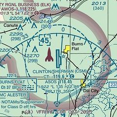
|
 Download PDF
of official airport diagram from the FAA
| Airport distance calculator |
|---|
|
|
| Sunrise and sunset |
|---|
|
Times for 04-Jun-2026
| | Local
(UTC-5) | | Zulu
(UTC) |
|---|
| Morning civil twilight | | 05:54 | | 10:54 |
| Sunrise | | 06:23 | | 11:23 |
| Sunset | | 20:47 | | 01:47 |
| Evening civil twilight | | 21:16 | | 02:16 |
|
| Current date and time |
|---|
| Zulu (UTC) | 04-Jun-2026 19:36:32 |
|---|
| Local (UTC-5) | 04-Jun-2026 14:36:32 |
|---|
|
| METAR |
|---|
| KCSM | 041853Z 19018G24KT 10SM FEW060 32/18 A2997 RMK AO2 PK WND 19029/1806 SLP123 T03170178
|
KELK
11nm NW | 041855Z AUTO 20016KT 10SM FEW055 32/16 A2996 RMK AO2 T03210165 $
|
KCLK
17nm NE | 041855Z AUTO 18016G19KT 10SM CLR 31/16 A2997 RMK AO2
|
|
| TAF |
|---|
| KCSM | 041722Z 0418/0518 19015G25KT P6SM SCT035 SCT250 FM050100 16010KT P6SM BKN250 FM050500 17010KT P6SM BKN250 WS020/19030KT FM051500 19010G15KT P6SM BKN250
|
|
| NOTAMs |
|---|
NOTAMs are issued by the DoD/FAA and will open in a separate window not controlled by AirNav.
|
|


