FAA INFORMATION EFFECTIVE 16 APRIL 2026
Location
| FAA Identifier: | PHP |
| Lat/Long: | 44-02-55.4303N 101-35-55.8257W
44-02.923838N 101-35.930428W
44.0487306,-101.5988405
(estimated) |
| Elevation: | 2209.2 ft. / 673.4 m (surveyed) |
| Variation: | 07E (2015) |
| From city: | 3 miles E of PHILIP, SD |
| Time zone: | UTC -6 (UTC -7 during Standard Time) |
| Zip code: | 57567 |
Airport Operations
| Airport use: | Open to the public |
| Activation date: | 12/1937 |
| Control tower: | no |
| ARTCC: | DENVER CENTER |
| FSS: | HURON FLIGHT SERVICE STATION |
| NOTAMs facility: | PHP (NOTAM-D service available) |
| Attendance: | UNATNDD |
| Wind indicator: | lighted |
| Segmented circle: | yes |
| Lights: | ACTIVATE PAPI RY 12/30; MIRL RY 12/30 - CTAF. |
| Beacon: | white-green (lighted land airport)
Operates sunset to sunrise. |
Airport Communications
| CTAF/UNICOM: | 122.8 |
| WX ASOS: | 118.375 (605-206-3001) |
- APCH/DEP CTL SVC PRVDD BY DENVER ARTCC (ZDV) ON FREQS 127.95/338.2 (RAPID CITY RCAG).
- COMMUNICATIONS PRVDD BY HURON RADIO ON FREQ 122.4 (PHILIP RCO).
Nearby radio navigation aids
| VOR radial/distance | | VOR name | | Freq | | Var |
|---|
| PHPr089/2.9 | | PHILIP VOR/DME | | 115.55 | | 12E |
Airport Services
| Fuel available: | 100LL
100LL:FUEL AVBL 24 HRS WITH CREDIT CARD. |
| Parking: | hangars and tiedowns |
| Airframe service: | NONE |
| Powerplant service: | NONE |
| Bottled oxygen: | NONE |
| Bulk oxygen: | NONE |
Runway Information
Runway 12/30
| Dimensions: | 3998 x 75 ft. / 1219 x 23 m |
| Surface: | asphalt, in excellent condition |
| Weight bearing capacity: | |
| Runway edge lights: | medium intensity |
| RUNWAY 12 | | RUNWAY 30 |
| Latitude: | 44-03.077278N | | 44-02.670458N |
| Longitude: | 101-36.348877W | | 101-35.632062W |
| Elevation: | 2208.9 ft. | | 2193.9 ft. |
| Traffic pattern: | left | | left |
| Runway heading: | 121 magnetic, 128 true | | 301 magnetic, 308 true |
| Markings: | nonprecision, in good condition | | nonprecision, in good condition |
| Visual slope indicator: | 2-light PAPI on left (3.00 degrees glide path) | | 2-light PAPI on left (3.00 degrees glide path) |
| Touchdown point: | yes, no lights | | yes, no lights |
| Obstructions: | 31 ft. pole, 922 ft. from runway, 23:1 slope to clear | | none |
Runway 5/23
| Dimensions: | 3588 x 120 ft. / 1094 x 37 m |
| Surface: | turf, in fair condition |
| Runway edge markings: | 05/23 MARKED WITH BLACK/WHITE CONES |
| RUNWAY 5 | | RUNWAY 23 |
| Latitude: | 44-02.846573N | | 44-03.112460N |
| Longitude: | 101-36.229080W | | 101-35.497975W |
| Elevation: | 2200.8 ft. | | 2198.2 ft. |
| Traffic pattern: | left | | left |
| Runway heading: | 056 magnetic, 063 true | | 236 magnetic, 243 true |
| Touchdown point: | yes, no lights | | yes, no lights |
| Obstructions: | none | | 16 ft. tree, 348 ft. from runway, 100 ft. right of centerline, 22:1 slope to clear |
Airport Ownership and Management from official FAA records
| Ownership: | Publicly-owned |
| Owner: | CITY OF PHILIP
PO BOX 408
PHILIP, SD 57567
Phone 605-859-2175 |
| Manager: | BRITTANY SMITH
PO BOX 408
PHILIP, SD 57567
Phone 605-859-2175 |
Additional Remarks
| - | FOR CD IF UNA TO CTC ON FSS FREQ, CTC DENVER ARTCC AT 303-651-4257. |
Instrument Procedures
NOTE: All procedures below are presented as PDF files. If you need a reader for these files, you should download the free Adobe Reader.NOT FOR NAVIGATION. Please procure official charts for flight.
FAA instrument procedures published for use from 16 April 2026 at 0901Z to 14 May 2026 at 0900Z.
IAPs - Instrument Approach Procedures |
|---|
| RNAV (GPS) RWY 12 | |
download (241KB) |
| RNAV (GPS) RWY 30 | |
download (238KB) |
| VOR-A | |
download (167KB) |
| NOTE: Special Alternate Minimums apply | |
download (47KB) |
| NOTE: Special Take-Off Minimums/Departure Procedures apply | |
download (162KB) |
Other nearby airports with instrument procedures:
9V6 - Martin Municipal Airport (53 nm S)
KSUO - Rosebud Sioux Tribal Airport (57 nm SE)
84D - Cheyenne Eagle Butte Airport (58 nm N)
KPIR - Pierre Regional Airport (60 nm E)
KRAP - Rapid City Regional Airport (63 nm W)
|
|

Road maps at:
MapQuest
Bing
Google
| Aerial photo |
|---|
WARNING: Photo may not be current or correct
 Photo by Dale N Scobie
Photo taken 05-Aug-2006
from 5,800 feet AGL
Photo by Dale N Scobie
Photo taken 05-Aug-2006
from 5,800 feet AGL
Do you have a better or more recent aerial photo of Philip Airport that you would like to share? If so, please send us your photo.
|
| Sectional chart |
|---|
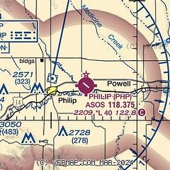
|
| Airport distance calculator |
|---|
|
|
| Sunrise and sunset |
|---|
|
Times for 26-Apr-2026
| | Local
(UTC-6) | | Zulu
(UTC) |
|---|
| Morning civil twilight | | 05:15 | | 11:15 |
| Sunrise | | 05:46 | | 11:46 |
| Sunset | | 19:42 | | 01:42 |
| Evening civil twilight | | 20:13 | | 02:13 |
|
| Current date and time |
|---|
| Zulu (UTC) | 26-Apr-2026 21:45:07 |
|---|
| Local (UTC-6) | 26-Apr-2026 15:45:07 |
|---|
|
| METAR |
|---|
| KPHP | 262123Z AUTO 08014KT 5SM RA BR OVC010 05/04 A2981 RMK AO2 P0004 T00500039 $
|
|
| NOTAMs |
|---|
NOTAMs are issued by the DoD/FAA and will open in a separate window not controlled by AirNav.
|
|

