FAA INFORMATION EFFECTIVE 14 MAY 2026
Location
| FAA Identifier: | PTS |
| Lat/Long: | 37-27-00.2000N 094-43-52.4000W
37-27.003333N 094-43.873333W
37.4500556,-94.7312222
(estimated) |
| Elevation: | 946.2 ft. / 288.4 m (surveyed) |
| Variation: | 02E (2015) |
| From city: | 3 miles NW of PITTSBURG, KS |
| Time zone: | UTC -5 (UTC -6 during Standard Time) |
| Zip code: | 66762 |
Airport Operations
| Airport use: | Open to the public |
| Activation date: | 04/1940 |
| Control tower: | no |
| ARTCC: | KANSAS CITY CENTER |
| FSS: | WICHITA FLIGHT SERVICE STATION |
| NOTAMs facility: | ICT (NOTAM-D service available) |
| Attendance: | MON-FRI 0700-1700, ALL SAT-SUN 0800-1600 |
| Wind indicator: | lighted |
| Segmented circle: | no |
| Lights: | ACTVT MIRL RWYS 04/22 & 17/35; PAPI & REIL RWYS 17, 35, 04 & 22 - CTAF. |
| Beacon: | white-green (lighted land airport)
Operates sunset to sunrise. |
Airport Communications
| CTAF/UNICOM: | 123.0 |
| WX AWOS-3PT: | 118.775 (620-404-5654) |
- APCH/DEP CTL SVC PRVDD BY KANSAS CITY ARTCC (ZKC) ON FREQS 128.6/282.325 (EDNA RCAG).
Airport Services
| Fuel available: | 100LL JET-A |
| Parking: | hangars and tiedowns |
| Airframe service: | MAJOR |
| Powerplant service: | MAJOR |
| Bottled oxygen: | HIGH/LOW |
| Bulk oxygen: | NONE |
Runway Information
Runway 17/35
| Dimensions: | 6100 x 100 ft. / 1859 x 30 m |
| Surface: | asphalt, in good condition |
| Weight bearing capacity: | | PCN 17 /F/D/X/T | | Single wheel: | 44.0 | | Double wheel: | 58.0 |
|
| Runway edge lights: | medium intensity |
| Runway edge markings: | MKGS FADED. |
| RUNWAY 17 | | RUNWAY 35 |
| Latitude: | 37-27.603545N | | 37-26.614117N |
| Longitude: | 094-43.956383W | | 094-43.734083W |
| Elevation: | 936.3 ft. | | 926.5 ft. |
| Traffic pattern: | left | | left |
| Runway heading: | 168 magnetic, 170 true | | 348 magnetic, 350 true |
| Markings: | nonprecision, in poor condition | | nonprecision, in poor condition |
| Visual slope indicator: | 4-light PAPI on left (3.00 degrees glide path) | | 4-light PAPI on left (3.00 degrees glide path) |
| Runway end identifier lights: | yes | | yes |
| Touchdown point: | yes, no lights | | yes, no lights |
| Obstructions: | 46 ft. trees, 1136 ft. from runway, 195 ft. right of centerline, 20:1 slope to clear | | 53 ft. trees, 1230 ft. from runway, 396 ft. right of centerline, 19:1 slope to clear |
Runway 4/22
| Dimensions: | 4000 x 75 ft. / 1219 x 23 m |
| Surface: | asphalt, in good condition |
| Weight bearing capacity: | | PCN 9 /F/D/X/T | | Single wheel: | 24.0 |
|
| Runway edge lights: | medium intensity |
| RUNWAY 4 | | RUNWAY 22 |
| Latitude: | 37-26.587512N | | 37-27.093445N |
| Longitude: | 094-44.179822W | | 094-43.650132W |
| Elevation: | 946.2 ft. | | 922.3 ft. |
| Traffic pattern: | left | | left |
| Runway heading: | 038 magnetic, 040 true | | 218 magnetic, 220 true |
| Markings: | nonprecision, in good condition | | nonprecision, in good condition |
| Visual slope indicator: | 4-light PAPI on left (3.00 degrees glide path) | | 4-light PAPI on left (3.80 degrees glide path) |
| Runway end identifier lights: | yes | | yes |
| Touchdown point: | yes, no lights | | yes, no lights |
| Obstructions: | 44 ft. trees, 450 ft. from runway, 148 ft. left of centerline, 5:1 slope to clear | | 47 ft. trees, 377 ft. from runway, 204 ft. right of centerline, 3:1 slope to clear |
Airport Ownership and Management from official FAA records
| Ownership: | Publicly-owned |
| Owner: | CITY OF PITTSBURG
201 W 4TH ST
PITTSBURG, KS 66762
Phone 620-231-4100 |
| Manager: | BILL PYLE
3510 ARPT DR
PITTSBURG, KS 66762
Phone 620-231-5760 |
Additional Remarks
| - | BIRDS ON & INVOF ARPT. |
| - | FOR CD IF UNA TO CTC ON FSS FREQ, CTC KANSAS CITY ARTCC AT 913-254-8508. |
Instrument Procedures
NOTE: All procedures below are presented as PDF files. If you need a reader for these files, you should download the free Adobe Reader.NOT FOR NAVIGATION. Please procure official charts for flight.
FAA instrument procedures published for use from 14 May 2026 at 0901Z to 11 June 2026 at 0900Z.
IAPs - Instrument Approach Procedures |
|---|
| RNAV (GPS) RWY 04 | |
download (190KB) |
| RNAV (GPS) RWY 17 | |
download (198KB) |
| RNAV (GPS) RWY 22 | |
download (198KB) |
| RNAV (GPS) RWY 35 | |
download (205KB) |
| NOTE: Special Alternate Minimums apply | |
download (145KB) |
| NOTE: Special Take-Off Minimums/Departure Procedures apply | |
download (361KB) |
Other nearby airports with instrument procedures:
KLLU - Lamar Municipal Airport (20 nm E)
KFSK - Fort Scott Municipal Airport (21 nm N)
KJLN - Joplin Regional Airport (21 nm SE)
KNVD - Nevada Municipal Airport (32 nm NE)
KMIO - Miami Regional Airport (33 nm S)
|
|

Road maps at:
MapQuest
Bing
Google
| Aerial photo |
|---|
WARNING: Photo may not be current or correct
 Photo by Gregory White
Photo taken 30-Apr-2008
Photo by Gregory White
Photo taken 30-Apr-2008
Do you have a better or more recent aerial photo of Atkinson Municipal Airport that you would like to share? If so, please send us your photo.
|
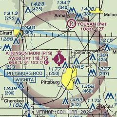
| Sectional chart |
|---|
|
| Airport distance calculator |
|---|
|
|
| Sunrise and sunset |
|---|
|
Times for 03-Jun-2026
| | Local
(UTC-5) | | Zulu
(UTC) |
|---|
| Morning civil twilight | | 05:29 | | 10:29 |
| Sunrise | | 06:00 | | 11:00 |
| Sunset | | 20:34 | | 01:34 |
| Evening civil twilight | | 21:05 | | 02:05 |
|
| Current date and time |
|---|
| Zulu (UTC) | 04-Jun-2026 01:31:17 |
|---|
| Local (UTC-5) | 03-Jun-2026 20:31:17 |
|---|
|
| METAR |
|---|
| KPTS | 040115Z AUTO 13006KT 10SM CLR 25/17 A3009 RMK AO2
|
|
| TAF |
|---|
KJLN
21nm SE | 031720Z 0318/0418 12009KT P6SM FEW250 FM040400 15007KT P6SM SCT250
|
|
| NOTAMs |
|---|
NOTAMs are issued by the DoD/FAA and will open in a separate window not controlled by AirNav.
|
|

