FAA INFORMATION EFFECTIVE 14 MAY 2026
Location
| FAA Identifier: | JLN |
| Lat/Long: | 37-09-11.4020N 094-29-55.7070W
37-09.190033N 094-29.928450W
37.1531672,-94.4988075
(estimated) |
| Elevation: | 977.9 ft. / 298.1 m (surveyed) |
| Variation: | 04E (2000) |
| From city: | 4 miles N of JOPLIN, MO |
| Time zone: | UTC -5 (UTC -6 during Standard Time) |
| Zip code: | 64870 |
Airport Operations
| Airport use: | Open to the public |
| Activation date: | 04/1940 |
| Control tower: | yes |
| ARTCC: | KANSAS CITY CENTER |
| FSS: | COLUMBIA FLIGHT SERVICE STATION |
| NOTAMs facility: | JLN (NOTAM-D service available) |
| Attendance: | 0500-0000 |
| Wind indicator: | lighted |
| Segmented circle: | no |
| Lights: | WHEN ATCT CLSD ACTVT MALSF RWY 13; ODALS RWY 31; PAPI RWY 18; HIRL RWY 13/31 - CTAF. MALSR RWY 18; PAPI RWY 31; HIRL RWY 18/36 - OPR DUSK-DAWN. |
| Beacon: | white-green (lighted land airport)
Operates sunset to sunrise. |
| Fire and rescue: | ARFF index A |
| Airline operations: | PPR 48 HRS FOR UNSKED ACR OPNS WITH MORE THAN 30 PSGR SEATS CALL AMGR 417-623-0262. |
Airport Communications
| CTAF: | 119.8 |
| UNICOM: | 122.95 |
| ATIS: | 120.85 |
| WX ASOS: | PHONE 417-623-8892 |
| JOPLIN GROUND: | 121.6 [0600-2100] |
| JOPLIN TOWER: | 119.8 [0600-2100] |
- APCH/DEP SVC PRVDD BY KANSAS CITY ARTCC ON FREQS 128.6/282.325 (EDNA RCAG).
Nearby radio navigation aids
| NDB name | | Hdg/Dist | | Freq | | Var | | ID |
|---|
| LUNNS | | 132/4.1 | | 344 | | 04E | | JL | .--- .-.. |
Airport Services
| Fuel available: | 100LL JET-A |
| Parking: | hangars and tiedowns |
| Airframe service: | MAJOR |
| Powerplant service: | MAJOR |
| Bottled oxygen: | NONE |
| Bulk oxygen: | LOW |
Runway Information
Runway 18/36
| Dimensions: | 6502 x 100 ft. / 1982 x 30 m |
| Surface: | concrete/grooved, in excellent condition |
| Weight bearing capacity: | | Single wheel: | 120.0 | | Double wheel: | 175.0 | | Double tandem: | 268.0 | | Dual double tandem: | 652.0 |
|
| Runway edge lights: | high intensity |
| RUNWAY 18 | | RUNWAY 36 |
| Latitude: | 37-09.844708N | | 37-08.773997N |
| Longitude: | 094-29.844318W | | 094-29.890162W |
| Elevation: | 949.4 ft. | | 971.1 ft. |
| Traffic pattern: | left | | left |
| Runway heading: | 178 magnetic, 182 true | | 358 magnetic, 002 true |
| Declared distances: | TORA:6499 TODA:6499 ASDA:6499 LDA:6499 | | TORA:6499 TODA:6499 ASDA:6499 LDA:6499 |
| Markings: | precision, in good condition | | nonprecision, in good condition |
| Visual slope indicator: | 4-light PAPI on left (3.00 degrees glide path) | | 4-light PAPI on left (3.00 degrees glide path) |
| RVR equipment: | touchdown | | rollout |
| Approach lights: | MALSR: 1,400 foot medium intensity approach lighting system with runway alignment indicator lights | | |
| Touchdown point: | yes, no lights | | yes, no lights |
| Instrument approach: | ILS/DME | | |
| Obstructions: | 15 ft. pole, 675 ft. from runway, 400 ft. right of centerline, 31:1 slope to clear | | none |
Runway 13/31
| Dimensions: | 6501 x 150 ft. / 1982 x 46 m |
| Surface: | asphalt/grooved, in good condition |
| Weight bearing capacity: | | Single wheel: | 80.0 | | Double wheel: | 105.0 | | Double tandem: | 170.0 |
|
| Runway edge lights: | high intensity |
| RUNWAY 13 | | RUNWAY 31 |
| Latitude: | 37-09.468538N | | 37-08.672825N |
| Longitude: | 094-30.437615W | | 094-29.541783W |
| Elevation: | 947.2 ft. | | 976.7 ft. |
| Traffic pattern: | left | | left |
| Runway heading: | 134 magnetic, 138 true | | 314 magnetic, 318 true |
| Displaced threshold: | 388 ft. | | 299 ft. |
| Declared distances: | TORA:6500 TODA:6500 ASDA:6201 LDA:5813 | | TORA:6500 TODA:6500 ASDA:6112 LDA:5813 |
| Markings: | precision, in fair condition | | nonprecision, in fair condition |
| Visual slope indicator: | | | 4-light PAPI on left (3.00 degrees glide path) |
| RVR equipment: | touchdown | | |
| Approach lights: | MALSF: 1,400 foot medium intensity approach lighting system with sequenced flashers | | ODALS: omnidirectional approach lighting system |
| Touchdown point: | yes, no lights | | yes, no lights |
| Instrument approach: | ILS | | |
| Obstructions: | 36 ft. tree, 825 ft. from runway, 490 ft. right of centerline, 17:1 slope to clear
APCH RATIO FROM DSPLCD THR 33:1 | | 47 ft. tree, 1200 ft. from runway, 300 ft. left of centerline, 21:1 slope to clear
APCH RATIO FROM DSPLCD THR 32:1 |
Airport Ownership and Management from official FAA records
| Ownership: | Publicly-owned |
| Owner: | CITY OF JOPLIN
602 S. MAIN STREET
JOPLIN, MO 64802-1355
Phone 417-624-0820 |
| Manager: | MS. ALLISON ZAHNER
7331 STATE HWY 43
JOPLIN, MO 64801
Phone 417-623-0262 |
Additional Remarks
| A39-18/36 | PCR VALUE: 590/R/D/W/T |
| A39-13/31 | PCR VALUE: 630/F/D/X/T |
| - | BIRDS ON & INVOF ARPT SPRING & FALL. |
| - | PPR 48 HRS FOR ACFT CARRYING HAZARDOUS OR EXPLOSIVE CARGO. |
| - | FOR CD IF UNA TO CTC ON FSS FREQ, CTC KANSAS CITY ARTCC AT 913-254-8508. |
Instrument Procedures
NOTE: All procedures below are presented as PDF files. If you need a reader for these files, you should download the free Adobe Reader.NOT FOR NAVIGATION. Please procure official charts for flight.
FAA instrument procedures published for use from 14 May 2026 at 0901Z to 11 June 2026 at 0900Z.
IAPs - Instrument Approach Procedures |
|---|
| ILS OR LOC RWY 13 | |
download (220KB) |
| ILS OR LOC RWY 18 | |
download (261KB) |
| RNAV (GPS) RWY 13 | |
download (211KB) |
| RNAV (GPS) RWY 18 | |
download (217KB) |
| RNAV (GPS) RWY 31 | |
download (207KB) |
| RNAV (GPS) RWY 36 | |
download (210KB) |
| NOTE: Special Alternate Minimums apply | |
download (146KB) |
| NOTE: Special Take-Off Minimums/Departure Procedures apply | |
download (314KB) |
Other nearby airports with instrument procedures:
KPTS - Atkinson Municipal Airport (21 nm NW)
KEOS - Neosho Hugh Robinson Airport (21 nm S)
KLLU - Lamar Municipal Airport (22 nm NE)
KMIO - Miami Regional Airport (24 nm SW)
KHFJ - Monett Regional Airport (28 nm SE)
|
|

Road maps at:
MapQuest
Bing
Google
| Aerial photo |
|---|
WARNING: Photo may not be current or correct

Do you have a better or more recent aerial photo of Joplin Regional Airport that you would like to share? If so, please send us your photo.
|
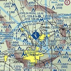
| Sectional chart |
|---|
|
CAUTION: Diagram may not be current
 Download PDF
of official airport diagram from the FAA
| Airport distance calculator |
|---|
|
|
| Sunrise and sunset |
|---|
|
Times for 24-May-2026
| | Local
(UTC-5) | | Zulu
(UTC) |
|---|
| Morning civil twilight | | 05:34 | | 10:34 |
| Sunrise | | 06:04 | | 11:04 |
| Sunset | | 20:25 | | 01:25 |
| Evening civil twilight | | 20:55 | | 01:55 |
|
| Current date and time |
|---|
| Zulu (UTC) | 24-May-2026 11:05:48 |
|---|
| Local (UTC-5) | 24-May-2026 06:05:48 |
|---|
|
| METAR |
|---|
| KJLN | 241053Z 00000KT 1/4SM FG VV002 14/14 A3005 RMK AO2 SLP172 T01390139
|
|
| TAF |
|---|
| KJLN | 240533Z 2406/2506 VRB01KT 3/4SM BR VV002 TEMPO 2406/2408 1/4SM FG VV002 FM240800 VRB01KT 1/2SM FG VV002 FM241400 03006KT P6SM FEW250 FM250000 VRB05KT P6SM FEW250
|
|
| NOTAMs |
|---|
NOTAMs are issued by the DoD/FAA and will open in a separate window not controlled by AirNav.
|
|


