FAA INFORMATION EFFECTIVE 09 JULY 2026
Location
| FAA Identifier: | TAD |
| Lat/Long: | 37-15-33.2050N 104-20-27.1010W
37-15.553417N 104-20.451683W
37.2592236,-104.3408614
(estimated) |
| Elevation: | 5761.6 ft. / 1756.1 m (surveyed) |
| Variation: | 10E (1995) |
| From city: | 10 miles NE of TRINIDAD, CO |
| Time zone: | UTC -6 (UTC -7 during Standard Time) |
| Zip code: | 81082 |
Airport Operations
| Airport use: | Open to the public |
| Activation date: | 04/1940 |
| Control tower: | no |
| ARTCC: | DENVER CENTER |
| FSS: | DENVER FLIGHT SERVICE STATION |
| NOTAMs facility: | TAD (NOTAM-D service available) |
| Attendance: | MON-FRI 0800-1700 |
| Wind indicator: | lighted |
| Segmented circle: | no |
| Lights: | ACTVT REIL RWY 03 & 21; PAPI RWY 03 & 21; MIRL RWY 03/21 - CTAF. PPR. |
| Beacon: | white-green (lighted land airport)
Operates sunset to sunrise. |
| Landing fee: | yes |
Airport Communications
| CTAF/UNICOM: | 122.8 |
| WX ASOS: | 119.025 (719-845-1156) |
- APCH/DEP CTL SVC PRVDD BY DENVER ARTCC (ZDV) ON FREQS 128.375/379.95 (PUEBLO RCAG).
Nearby radio navigation aids
| VOR radial/distance | | VOR name | | Freq | | Var |
|---|
| TBEr258/35.4 | | TOBE VOR/DME | | 114.05 | | 12E |
Airport Services
| Fuel available: | 100LL JET-A+ |
| Parking: | hangars and tiedowns |
Runway Information
Runway 3/21
| Dimensions: | 5500 x 75 ft. / 1676 x 23 m |
| Surface: | asphalt, in excellent condition |
| Weight bearing capacity: | | Single wheel: | 37.0 | | Double wheel: | 50.0 |
|
| Runway edge lights: | medium intensity |
| RUNWAY 3 | | RUNWAY 21 |
| Latitude: | 37-15.260025N | | 37-15.901728N |
| Longitude: | 104-20.654030W | | 104-19.853760W |
| Elevation: | 5760.4 ft. | | 5740.3 ft. |
| Traffic pattern: | left | | right |
| Runway heading: | 035 magnetic, 045 true | | 215 magnetic, 225 true |
| Markings: | nonprecision, in good condition | | nonprecision, in good condition |
| Visual slope indicator: | 2-light PAPI on left (3.00 degrees glide path) | | 2-light PAPI on left (3.00 degrees glide path) |
| Runway end identifier lights: | yes | | yes |
| Touchdown point: | yes, no lights | | yes, no lights |
Runway 9/27
| Dimensions: | 5500 x 100 ft. / 1676 x 30 m |
| Surface: | turf/gravel, in fair condition |
| Operational restrictions: | +3-6 FT BUSHES ON EDGE BOTH SIDES ALG ENTRE LEN; SOFT WHEN WET; PRAIRIE DOG HOLES THRUT. |
| RUNWAY 9 | | RUNWAY 27 |
| Latitude: | 37-15.651667N | | 37-15.400167N |
| Longitude: | 104-21.194000W | | 104-20.104833W |
| Elevation: | 5759.3 ft. | | 5747.7 ft. |
| Traffic pattern: | left | | left |
| Runway heading: | 096 magnetic, 106 true | | 276 magnetic, 286 true |
| Markings: | none, in poor condition | | none, in poor condition |
| Touchdown point: | yes, no lights | | yes, no lights |
| Obstructions: | 41 ft. trees, 784 ft. from runway, 151 ft. left of centerline, 19:1 slope to clear | | none |
Airport Ownership and Management from official FAA records
| Ownership: | Publicly-owned |
| Owner: | LAS ANIMAS COUNTY
PHIL DORENKAMP, 200 E 1ST ST
TRINIDAD, CO 81082-9607
Phone 719-845-2598 |
| Manager: | EVAN OTTO
44814 CO RD 38.0
TRINIDAD, CO 81082-9607
Phone 719-680-7831 |
Additional Remarks
| A30A-09 | +40 FT TREES 846 FT FM THR 137 FT RIGHT; +4 FT BUSHES & +3 FT POSTS WI 100 FT OF RWY END BOTH SIDES OF CNTRLN. |
| - | FOR CD IF UNA TO CTC ON FSS FREQ, CTC DENVER ARTCC AT 303-651-4257. |
| - | TWYS HAVE BLUE/WHITE REFLECTORS AT PAVEMENT EDGE. |
| - | ALERT: USAF STUDENT TRNG INVOF COLORADO SPRINGS & PUEBLO CO. |
Instrument Procedures
NOTE: All procedures below are presented as PDF files. If you need a reader for these files, you should download the free Adobe Reader.NOT FOR NAVIGATION. Please procure official charts for flight.
FAA instrument procedures published for use from 09 July 2026 at 0901Z to 06 August 2026 at 0900Z.
IAPs - Instrument Approach Procedures |
|---|
| RNAV (GPS) RWY 03 | |
download (224KB) |
| RNAV (GPS) RWY 21 | |
download (230KB) |
| NOTE: Special Alternate Minimums apply | |
download (55KB) |
|
|---|
| TRINIDAD ONE (OBSTACLE) (RNAV) | |
download (160KB) |
| NOTE: Special Take-Off Minimums/Departure Procedures apply | |
download (150KB) |
Other nearby airports with instrument procedures:
KRTN - Raton Municipal Airport/Crews Field (32 nm S)
4V1 - Spanish Peaks Airfield (34 nm NW)
KLHX - La Junta Municipal Airport (62 nm NE)
KPUB - Pueblo Memorial Airport (62 nm N)
KAXX - Angel Fire Airport (68 nm SW)
|
|

Road maps at:
MapQuest
Bing
Google
| Aerial photo |
|---|
WARNING: Photo may not be current or correct
 Photo by Ray Fey
Photo taken 16-Mar-2013
looking north-northeast.
Photo by Ray Fey
Photo taken 16-Mar-2013
looking north-northeast.
Do you have a better or more recent aerial photo of Perry Stokes Airport that you would like to share? If so, please send us your photo.
|
| Sectional chart |
|---|
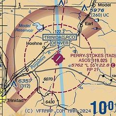
|
| Airport distance calculator |
|---|
|
|
| Sunrise and sunset |
|---|
|
Times for 01-Aug-2026
| | Local
(UTC-6) | | Zulu
(UTC) |
|---|
| Morning civil twilight | | 05:34 | | 11:34 |
| Sunrise | | 06:03 | | 12:03 |
| Sunset | | 20:04 | | 02:04 |
| Evening civil twilight | | 20:33 | | 02:33 |
|
| Current date and time |
|---|
| Zulu (UTC) | 01-Aug-2026 22:01:48 |
|---|
| Local (UTC-6) | 01-Aug-2026 16:01:48 |
|---|
|
| METAR |
|---|
| KTAD | 012154Z AUTO VRB04KT 10SM CLR 32/09 A3024 RMK AO2 SLP149 T03170089
|
|
| NOTAMs |
|---|
NOTAMs are issued by the DoD/FAA and will open in a separate window not controlled by AirNav.
|
|


