FAA INFORMATION EFFECTIVE 09 JULY 2026
Location
| FAA Identifier: | SAW |
| Lat/Long: | 46-20-56.9700N 087-23-46.9380W
46-20.949500N 087-23.782300W
46.3491583,-87.3963717
(estimated) |
| Elevation: | 1204.5 ft. / 367.1 m (surveyed) |
| Variation: | 04W (2000) |
| From city: | 17 miles S of MARQUETTE, MI |
| Time zone: | UTC -4 (UTC -5 during Standard Time) |
| Zip code: | 49841 |
Airport Operations
| Airport use: | Open to the public |
| Control tower: | yes |
| ARTCC: | MINNEAPOLIS CENTER |
| FSS: | GREEN BAY FLIGHT SERVICE STATION |
| NOTAMs facility: | SAW (NOTAM-D service available) |
| Attendance: | 0500-2000
FOR SVC AFT HRS CALL AMGR CELL OR 810-417-1860. |
| Wind indicator: | lighted |
| Segmented circle: | yes |
| Lights: | WHEN ATCT CLSD, ACTVT MALSR RWY 01; REIL RWY 19; PAPI RWYS 01 & 19; HIRL RWY 01/19 - CTAF. |
| Beacon: | white-green (lighted land airport)
Operates sunset to sunrise. |
| Landing fee: | yes |
| Fire and rescue: | ARFF index B |
| Airline operations: | ACR OPS ARE NOT AUZD IN EXCESS OF 15 MINS BFR OR AFT SKED ARR/DEP TIMES WO PRIOR COORD WITH AMGR. UNSKED ACR OPNS WITH MORE THAN 30 PSGR SEATS REQ 48 HR PRIOR PMSN , CALL AMGR 906-346-3308 OR 906-364-0939. INDEX C ARFF AVBL WITH 48 HR PRIOR PMSN, CALL AMGR 906-346-3308 OR 906-364-0939. |
Airport Communications
| CTAF: | 119.975 |
| UNICOM: | 122.7 |
| WX AWOS-3PT: | 118.375 (906-346-5126) |
| SAWYER GROUND: | 121.65 [0600-2200] |
| SAWYER TOWER: | 119.975 [0600-2200] |
- APCH/DEP SVC PRVDD BY MINNEAPOLIS ARTCC (ZMP) ON FREQS 119.1/290.2 (GWINN RCAG).
Nearby radio navigation aids
| VOR radial/distance | | VOR name | | Freq | | Var |
|---|
| SAW at field | | SAWYER VOR/DME | | 117.10 | | 04W |
| ESCr341/39.7 | | ESCANABA VOR/DME | | 113.55 | | 00E |
Airport Services
| Fuel available: | 100LL JET-A |
| Parking: | hangars and tiedowns |
| Airframe service: | MAJOR |
| Powerplant service: | MAJOR |
| Bulk oxygen: | HIGH/LOW |
Runway Information
Runway 1/19
| Dimensions: | 9072 x 150 ft. / 2765 x 46 m |
| Surface: | asphalt/grooved, in good condition |
| Weight bearing capacity: | | Single wheel: | 111.0 | | Double wheel: | 184.0 | | Double tandem: | 312.0 | | Dual double tandem: | 750.0 |
|
| Runway edge lights: | high intensity |
| RUNWAY 1 | | RUNWAY 19 |
| Latitude: | 46-20.212377N | | 46-21.686620N |
| Longitude: | 087-23.950068W | | 087-23.614460W |
| Elevation: | 1178.6 ft. | | 1204.5 ft. |
| Traffic pattern: | left | | left |
| Runway heading: | 013 magnetic, 009 true | | 193 magnetic, 189 true |
| Declared distances: | TORA:9072 TODA:9072 ASDA:9072 LDA:9072 | | TORA:9072 TODA:9072 ASDA:9072 LDA:9072 |
| Markings: | precision, in fair condition | | precision, in fair condition |
| Visual slope indicator: | 4-light PAPI on left (3.00 degrees glide path) | | 4-light PAPI on left (3.00 degrees glide path) |
| Approach lights: | MALSR: 1,400 foot medium intensity approach lighting system with runway alignment indicator lights | | |
| Runway end identifier lights: | | | yes |
| Touchdown point: | yes, no lights | | yes, no lights |
| Instrument approach: | ILS | | |
Airport Ownership and Management from official FAA records
| Ownership: | Publicly-owned |
| Owner: | MARQUETTE COUNTY
125 AVENUE G
GWINN, MI 49841-3108
Phone 906-346-3308 |
| Manager: | DAVID ERHART
MARQUETTE/SAWYER RGNL ARPT, 125 AVENUE G
GWINN, MI 49841-3108
Phone 906-346-3308
EXTN 3138; CELL 906-364-0939. |
Additional Remarks
| A39-01/19 | PCR VALUE: 450/F/B/X/T |
| - | BIRDS & DEER ON & INVOF ARPT. |
| - | RAMP FEE MAY BE WAIVED WITH FUEL PURCHASE; FOR FBO SVC AFT HRS CALL 906-251-0723. |
| - | FOR CD WHEN ATCT IS CLSD CTC FSS VIA RCO, IF UNA CTC MINNEAPOLIS ARTCC AT 651-463-5588. |
| - | FICONS UNMON 0000-0430. |
| - | GA & CHARTER ACFT PARKING AVBL AT GA TERMINAL ONLY, LCTD SE CORNER OF ARPT. |
| - | S HALF OF ACR TERMINAL RAMP NOT PLOWED OCT-APR. |
| - | FREQUENT SNOW REMOVAL OPNS IN PROGRESS VARIOUS TIMES OCT-APR. MONITOR CTAF. |
| - | PAEW ON ARPT MONITOR 119.975 (CTAF). |
| - | (CONTACT PHONE NR) EXTN 3131. |
Instrument Procedures
NOTE: All procedures below are presented as PDF files. If you need a reader for these files, you should download the free Adobe Reader.NOT FOR NAVIGATION. Please procure official charts for flight.
FAA instrument procedures published for use from 09 July 2026 at 0901Z to 06 August 2026 at 0900Z.
IAPs - Instrument Approach Procedures |
|---|
| ILS OR LOC RWY 01 | |
download (245KB) |
| RNAV (GPS) RWY 01 | |
download (194KB) |
| RNAV (GPS) RWY 19 | |
download (223KB) |
| NOTE: Special Take-Off Minimums/Departure Procedures apply | |
download (358KB) |
Other nearby airports with instrument procedures:
KESC - Delta County Airport (40 nm S)
KIMT - Ford Airport (44 nm SW)
KISQ - Schoolcraft County Airport (56 nm SE)
2P2 - Washington Island Airport (61 nm S)
KCMX - Houghton County Memorial Airport (67 nm NW)
|
|

Road maps at:
MapQuest
Bing
Google
| Aerial photo |
|---|
WARNING: Photo may not be current or correct
 Photo by Justin Fernelius
Photo taken 14-Jul-2019
looking northeast.
Photo by Justin Fernelius
Photo taken 14-Jul-2019
looking northeast.
Do you have a better or more recent aerial photo of Marquette/Sawyer Regional Airport that you would like to share? If so, please send us your photo.
|
| Sectional chart |
|---|
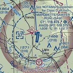
|
 Download PDF
of official airport diagram from the FAA
| Airport distance calculator |
|---|
|
|
| Sunrise and sunset |
|---|
|
Times for 26-Jul-2026
| | Local
(UTC-4) | | Zulu
(UTC) |
|---|
| Morning civil twilight | | 05:49 | | 09:49 |
| Sunrise | | 06:25 | | 10:25 |
| Sunset | | 21:27 | | 01:27 |
| Evening civil twilight | | 22:03 | | 02:03 |
|
| Current date and time |
|---|
| Zulu (UTC) | 26-Jul-2026 13:02:47 |
|---|
| Local (UTC-4) | 26-Jul-2026 09:02:47 |
|---|
|
| METAR |
|---|
| KSAW | 261246Z 24003KT 10SM CLR 19/19 A2990
|
|
| TAF |
|---|
| KSAW | 260520Z 2606/2706 VRB03KT P6SM SKC FM260700 24003KT 3SM BR SCT002 FM261300 21008KT P6SM FEW060
|
|
| NOTAMs |
|---|
NOTAMs are issued by the DoD/FAA and will open in a separate window not controlled by AirNav.
|
|


