FAA INFORMATION EFFECTIVE 09 JULY 2026
Location
| FAA Identifier: | SAZ |
| Lat/Long: | 46-22-51.1660N 094-48-23.7660W
46-22.852767N 094-48.396100W
46.3808794,-94.8066017
(estimated) |
| Elevation: | 1287.6 ft. / 392.5 m (surveyed) |
| Variation: | 01E (2015) |
| From city: | 2 miles NW of STAPLES, MN |
| Time zone: | UTC -5 (UTC -6 during Standard Time) |
| Zip code: | 56479 |
Airport Operations
| Airport use: | Open to the public |
| Activation date: | 10/1946 |
| Control tower: | no |
| ARTCC: | MINNEAPOLIS CENTER |
| FSS: | PRINCETON FLIGHT SERVICE STATION |
| NOTAMs facility: | SAZ (NOTAM-D service available) |
| Attendance: | UNATNDD |
| Wind indicator: | lighted |
| Segmented circle: | no |
| Lights: | ACTVT REIL RWY 14 & 32; PAPI RWY 14 & 32; MIRL RWY 14/32 - CTAF. |
| Beacon: | white-green (lighted land airport)
Operates sunset to sunrise. |
Airport Communications
| CTAF: | 122.9 |
| WX AWOS-3: | 118.325 (218-894-3666) |
| WX AWOS-3PT at ADC (17 nm W): | 118.875 (218-631-7774) |
- APCH/DEP SVC PRVDD BY MINNEAPOLIS ARTCC ON FREQS 118.05/239.0 (BRAINERD RCAG).
Nearby radio navigation aids
| VOR radial/distance | | VOR name | | Freq | | Var |
|---|
| AXNr028/30.9 | | ALEXANDRIA VOR/DME | | 115.95 | | 07E |
| NDB name | | Hdg/Dist | | Freq | | Var | | ID |
|---|
| RIPLEY | | 310/26.4 | | 404 | | 03E | | XCR | -..- -.-. .-. |
Airport Services
| Fuel available: | 100LL
100LL:FUEL AVBL H24 SELF SVC VIA CREDIT CARD. |
| Parking: | tiedowns |
| Airframe service: | NONE |
| Powerplant service: | NONE |
| Bottled oxygen: | NONE |
| Bulk oxygen: | NONE |
Runway Information
Runway 14/32
| Dimensions: | 3305 x 75 ft. / 1007 x 23 m |
| Surface: | asphalt, in good condition |
| Runway edge lights: | medium intensity |
| RUNWAY 14 | | RUNWAY 32 |
| Latitude: | 46-23.075633N | | 46-22.631582N |
| Longitude: | 094-48.622757W | | 094-48.169240W |
| Elevation: | 1287.5 ft. | | 1284.6 ft. |
| Traffic pattern: | left | | left |
| Runway heading: | 144 magnetic, 145 true | | 324 magnetic, 325 true |
| Markings: | nonprecision, in good condition | | nonprecision, in good condition |
| Visual slope indicator: | 4-light PAPI on left (3.00 degrees glide path) | | 4-light PAPI on left (3.00 degrees glide path) |
| Runway end identifier lights: | yes | | yes |
| Touchdown point: | yes, no lights | | yes, no lights |
| Obstructions: | 24 ft. tree, 285 ft. from runway, 261 ft. right of centerline, 3:1 slope to clear
7 FT BRUSH, 45 FT DIST, 189 FT R. | | 53 ft. tree, 1137 ft. from runway, 291 ft. right of centerline, 17:1 slope to clear |
Airport Ownership and Management from official FAA records
| Ownership: | Publicly-owned |
| Owner: | CITY OF STAPLES
122 6TH ST NE
STAPLES, MN 56479-2900
Phone 218-894-2550 |
| Manager: | JEREL NELSEN
122 6TH ST NE
STAPLES, MN 56479-2900
Phone 218-894-2550 |
Additional Remarks
| - | GCO AVBL ON FREQ 121.725 THRU MINNEAPOLIS ARTCC & FLT SVCS. |
| - | ULTRALIGHT TFC ON & INVOF ARPT. |
| - | FOR CD IF UNA VIA GCO CTC MINNEAPOLIS ARTCC AT 651-463-5588. |
Instrument Procedures
NOTE: All procedures below are presented as PDF files. If you need a reader for these files, you should download the free Adobe Reader.NOT FOR NAVIGATION. Please procure official charts for flight.
FAA instrument procedures published for use from 09 July 2026 at 0901Z to 06 August 2026 at 0900Z.
IAPs - Instrument Approach Procedures |
|---|
| RNAV (GPS) RWY 14 | |
download (196KB) |
| RNAV (GPS) RWY 32 | |
download (253KB) |
| NOTE: Special Alternate Minimums apply | |
download (30KB) |
| NOTE: Special Take-Off Minimums/Departure Procedures apply | |
download (415KB) |
Other nearby airports with instrument procedures:
KADC - Wadena Municipal Airport (17 nm W)
KRYM - Ray S Miller Army Airfield (25 nm SE)
KPWC - Pine River Regional Airport (27 nm NE)
KBRD - Brainerd Lakes Regional Airport (28 nm E)
14Y - Todd Field Airport (29 nm S)
|
|

Road maps at:
MapQuest
Bing
Google
| Aerial photo |
|---|
WARNING: Photo may not be current or correct
 Photo taken 26-Nov-2006
just off of runway 32 @ 3000 ft MSL
Photo taken 26-Nov-2006
just off of runway 32 @ 3000 ft MSL
Do you have a better or more recent aerial photo of Staples Municipal Airport that you would like to share? If so, please send us your photo.
|
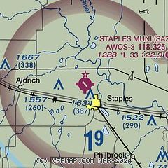
| Sectional chart |
|---|
|
| Airport distance calculator |
|---|
|
|
| Sunrise and sunset |
|---|
|
Times for 26-Jul-2026
| | Local
(UTC-5) | | Zulu
(UTC) |
|---|
| Morning civil twilight | | 05:19 | | 10:19 |
| Sunrise | | 05:54 | | 10:54 |
| Sunset | | 20:57 | | 01:57 |
| Evening civil twilight | | 21:33 | | 02:33 |
|
| Current date and time |
|---|
| Zulu (UTC) | 26-Jul-2026 21:22:55 |
|---|
| Local (UTC-5) | 26-Jul-2026 16:22:55 |
|---|
|
| METAR |
|---|
| KSAZ | 262055Z AUTO VRB06KT 10SM CLR 36/19 A2977 RMK AO2 T03600194 58002 $
|
KADC
17nm W | 262055Z AUTO 00000KT 10SM CLR 36/17 A2978 RMK AO2
|
|
| TAF |
|---|
KBRD
28nm E | 261730Z 2618/2718 21007KT P6SM SCT100 FM270900 VRB03KT 1SM BR SCT010 FM271400 34011KT P6SM FEW250
|
|
| NOTAMs |
|---|
NOTAMs are issued by the DoD/FAA and will open in a separate window not controlled by AirNav.
|
|

