FAA INFORMATION EFFECTIVE 16 APRIL 2026
Location
| FAA Identifier: | B16 |
| Lat/Long: | 43-04-50.2225N 076-32-17.5598W
43-04.837042N 076-32.292663W
43.0806174,-76.5382111
(estimated) |
| Elevation: | 400 ft. / 121.9 m (surveyed) |
| Variation: | 12W (1990) |
| From city: | 2 miles NE of WEEDSPORT, NY |
| Time zone: | UTC -4 (UTC -5 during Standard Time) |
| Zip code: | 13166 |
Airport Operations
| Airport use: | Open to the public |
| Activation date: | 03/1953 |
| Control tower: | no |
| ARTCC: | BOSTON CENTER |
| FSS: | BUFFALO FLIGHT SERVICE STATION |
| NOTAMs facility: | BUF (NOTAM-D service available) |
| Attendance: | DAYLIGHT HOURS |
| Pattern altitude: | 1200 ft. MSL |
| Wind indicator: | lighted |
| Segmented circle: | yes |
| Lights: | ACTVT MIRL RWY 10/28 - 122.7. |
| Beacon: | white-green (lighted land airport)
BEACON OTS INDEFLY. DUSK-2300. FOR ROTG BCN AFTER 2300 CALL 315-834-9950. |
Airport Communications
| CTAF/UNICOM: | 122.8 |
| SYRACUSE APPROACH: | 126.125 |
| SYRACUSE DEPARTURE: | 126.125 |
| WX AWOS-3P at 6B9 (11 nm SE): | 120.125 (315-685-5790) |
| WX AWOS-3 at 0G7 (16 nm SW): | 120.0 (315-568-5362) |
| WX ASOS at FZY (17 nm N): | 119.275 (315-598-8773) |
| WX ASOS at SYR (19 nm E): | PHONE 315-526-3244 |
Nearby radio navigation aids
| VOR radial/distance | | VOR name | | Freq | | Var |
|---|
| SYRr263/15.4 | | SYRACUSE VORTAC | | 117.00 | | 11W |
Airport Services
| Fuel available: | 100LL |
| Parking: | tiedowns |
| Airframe service: | MINOR |
| Powerplant service: | MINOR |
Runway Information
Runway 10/28
| Dimensions: | 3630 x 60 ft. / 1106 x 18 m |
| Surface: | asphalt, in good condition |
| Runway edge lights: | medium intensity |
| RUNWAY 10 | | RUNWAY 28 |
| Latitude: | 43-04.829583N | | 43-04.861533N |
| Longitude: | 076-32.765700W | | 076-31.951650W |
| Elevation: | 398.0 ft. | | 398.0 ft. |
| Traffic pattern: | left | | left |
| Runway heading: | 099 magnetic, 087 true | | 279 magnetic, 267 true |
| Displaced threshold: | 430 ft. | | 350 ft. |
| Markings: | nonprecision, in good condition | | nonprecision, in good condition |
| Touchdown point: | yes, no lights | | yes, no lights |
| Obstructions: | 64 ft. trees, 314 ft. from runway, 206 ft. left of centerline, 1:1 slope to clear | | 83 ft. trees, 350 ft. from runway, 270 ft. left of centerline, 1:1 slope to clear |
Runway E/W
| Dimensions: | 2800 x 100 ft. / 853 x 30 m |
| Surface: | turf, in good condition |
| RUNWAY E | | RUNWAY W |
| Latitude: | 43-04.811000N | | 43-04.841000N |
| Longitude: | 076-32.520833W | | 076-31.893333W |
| Elevation: | 393.0 ft. | | 393.0 ft. |
| Traffic pattern: | left | | left |
| Runway heading: | 098 magnetic, 086 true | | 278 magnetic, 266 true |
| Touchdown point: | yes, no lights | | yes, no lights |
| Obstructions: | 25 ft. hill, 373 ft. from runway, 100 ft. right of centerline, 14:1 slope to clear | | 63 ft. trees, 9 ft. from runway, 105 ft. left of centerline |
Airport Ownership and Management from official FAA records
| Ownership: | Privately-owned |
| Owner: | JOHN WHITFORD
3043 DITMAR ROAD
WEEDSPORT, NY 13166
Phone 315-834-9950 |
| Manager: | JOHN WHITFORD
3043 DITMAR ROAD
WEEDSPORT, NY 13166
Phone 315-834-9950 |
Additional Remarks
| - | RWY E/W CLSD NOV 1 - MAY 15. |
| - | ULTRA-LIGHTS ON & INVOF ARPT. |
| - | SKYDIVING ON & INVOF ARPT. |
| - | FOR CD CTC SYRACUSE APCH AT 315-455-6218. |
Instrument Procedures
NOTE: All procedures below are presented as PDF files. If you need a reader for these files, you should download the free Adobe Reader.NOT FOR NAVIGATION. Please procure official charts for flight.
FAA instrument procedures published for use from 16 April 2026 at 0901Z to 14 May 2026 at 0900Z.
IAPs - Instrument Approach Procedures |
|---|
| RNAV (GPS) RWY 10 | |
download (164KB) |
| NOTE: Special Take-Off Minimums/Departure Procedures apply | |
download (367KB) |
Other nearby airports with instrument procedures:
6B9 - Skaneateles Aero Drome (11 nm SE)
0G7 - Finger Lakes Regional Airport (16 nm SW)
KFZY - Oswego County Airport (17 nm N)
KSYR - Syracuse Hancock International Airport (19 nm E)
KSDC - Williamson/Sodus Airport (27 nm W)
|
|

Road maps at:
MapQuest
Bing
Google
| Aerial photo |
|---|
WARNING: Photo may not be current or correct
 Photo taken 11-Jun-2007
Do you have a better or more recent aerial photo of Whitfords Airport that you would like to share? If so, please send us your photo.
|
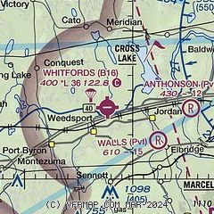
| Sectional chart |
|---|
|
| Airport distance calculator |
|---|
|
|
| Sunrise and sunset |
|---|
|
Times for 17-Apr-2026
| | Local
(UTC-4) | | Zulu
(UTC) |
|---|
| Morning civil twilight | | 05:52 | | 09:52 |
| Sunrise | | 06:22 | | 10:22 |
| Sunset | | 19:50 | | 23:50 |
| Evening civil twilight | | 20:19 | | 00:19 |
|
| Current date and time |
|---|
| Zulu (UTC) | 17-Apr-2026 14:22:58 |
|---|
| Local (UTC-4) | 17-Apr-2026 10:22:58 |
|---|
|
| METAR |
|---|
K6B9
11nm SE | 171355Z AUTO 00000KT M1/4SM FG OVC002 12/12 A2996 RMK AO2 P0001
|
KFZY
18nm NE | 171354Z AUTO 35006KT OVC002 11/10 A2996 RMK AO2 SLP146 T01060100 $
|
KSYR
19nm E | 171354Z 30009KT 6SM BR OVC003 13/12 A2995 RMK AO2 SLP139 T01280122
|
|
| TAF |
|---|
KSYR
19nm E | 171137Z 1712/1812 31004KT 6SM -RA BR OVC005 FM171600 31005KT P6SM BKN015 FM171900 31005KT P6SM BKN050 FM172100 31005KT P6SM SCT100
|
|
| NOTAMs |
|---|
NOTAMs are issued by the DoD/FAA and will open in a separate window not controlled by AirNav.
|
|

