FAA INFORMATION EFFECTIVE 14 MAY 2026
Location
| FAA Identifier: | SFB |
| Lat/Long: | 28-46-37.8410N 081-14-05.6890W
28-46.630683N 081-14.094817W
28.7771781,-81.2349136
(estimated) |
| Elevation: | 54.8 ft. / 16.7 m (surveyed) |
| Variation: | 05W (2000) |
| From city: | 16 miles NE of ORLANDO, FL |
| Time zone: | UTC -4 (UTC -5 during Standard Time) |
| Zip code: | 32773 |
Airport Operations
| Airport use: | Open to the public |
| Activation date: | 02/1943 |
| Control tower: | yes |
| ARTCC: | JACKSONVILLE CENTER |
| FSS: | SAINT PETERSBURG FLIGHT SERVICE STATION |
| NOTAMs facility: | SFB (NOTAM-D service available) |
| Attendance: | CONTINUOUS |
| Wind indicator: | lighted |
| Segmented circle: | yes |
| Lights: | WHEN ATCT CLSD ACTVT MALSR RWY 9R & 27R; PAPI RWYS 09L, 27R, 09C, 27C, 09R, 27L, 18, & 36; HIRL RWY 09L/27R, 09R/27L; MIRL RWY 18/36 & 9C/27C - CTAF. |
| Beacon: | white-green (lighted land airport)
Operates sunset to sunrise. |
| Fire and rescue: | ARFF index D |
| Airline operations: | CLSD TO REPETITIVE ACR TRNG OPS EXCP 24 HR PPR - AMGR 407-585-4000 EXT 4006 OR 407-585-4119. ARFF INDEX E AVBL WITH 24 HR PPR (CHARTER CARRIERS ON PUBLISHED SKED EXEMPT). |
| International operations: | customs landing rights airport |
Airport Communications
| CTAF: | 120.3 |
| ATIS: | 125.975 |
| WX ASOS: | 125.975 (407-321-9384) |
| SANFORD GROUND: | 121.35 254.35 [0630-2300] |
| SANFORD TOWER: | 120.3 254.35 135.25 [0630-2300] |
| ORLANDO APPROACH: | 125.225 ;SOUTH 135.3 ;NORTH |
| ORLANDO DEPARTURE: | 125.225 ;SOUTH 135.3 ;NORTH |
| CLEARANCE DELIVERY: | 121.35 ;WHEN SFB TWR CLSD 123.975 |
| ALYNA STAR: | 124.8 |
| CLASS C: | 125.225 ;SOUTH OF SFB WITHIN 20 NM 3 135.3 ;NORTH OF SFB WITHIN 20 NM 350 |
| EMERG: | 121.5 |
| JOKRS STAR: | 134.05 |
| MINEE STAR: | 134.05 |
| MUNGI STAR: | 128.375 |
| PRICY STAR: | 134.05 |
| SANFORD DP: | 135.3 |
| SHREK STAR: | 128.675 134.05 |
| TTHOR STAR: | 118.85 125.225 |
| WX ASOS at ORL (15 nm S): | 127.25 (407-658-6753) |
| WX AWOS-3 at DED (18 nm N): | 119.575 (386-740-5811) |
- 123.975 CLNC DEL AVBL WHEN ADVERTISED ON ATIS.
- SAID IN USE. OPERATE TRANSPONDERS WITH ALTITUDE REPORTING MODE AND ADS-B (IF EQUIPPED) ENABLED ON ALL AIRPORT SURFACES.
Nearby radio navigation aids
| VOR radial/distance | | VOR name | | Freq | | Var |
|---|
| ORLr021/15.0 | | ORLANDO VORTAC | | 112.20 | | 00E |
| OMNr191/32.2 | | ORMOND BEACH VORTAC | | 112.60 | | 00E |
Airport Services
| Fuel available: | 100LL JET-A |
| Parking: | hangars and tiedowns |
| Airframe service: | MAJOR |
| Powerplant service: | MAJOR |
| Bottled oxygen: | HIGH |
| Bulk oxygen: | NONE |
Runway Information
Runway 9L/27R
| Dimensions: | 11002 x 150 ft. / 3353 x 46 m |
| Surface: | asphalt/grooved, in good condition |
| Weight bearing capacity: | | Single wheel: | 100.0 | | Double wheel: | 279.0 | | Double tandem: | 840.0 |
|
| Runway edge lights: | high intensity |
| Operational restrictions: | PRIM ACR OPS RWY. |
| RUNWAY 9L | | RUNWAY 27R |
| Latitude: | 28-46.904128N | | 28-46.907332N |
| Longitude: | 081-15.357287W | | 081-13.296698W |
| Elevation: | 51.6 ft. | | 30.3 ft. |
| Traffic pattern: | left | | right |
| Runway heading: | 095 magnetic, 090 true | | 275 magnetic, 270 true |
| Displaced threshold: | 1000 ft. | | no |
| Declared distances: | TORA:11002 TODA:11002 ASDA:11002 LDA:10002 | | TORA:11002 TODA:11002 ASDA:11002 LDA:11002 |
| Markings: | precision, in good condition | | precision, in good condition |
| Visual slope indicator: | 4-light PAPI on left (3.00 degrees glide path) | | 4-light PAPI on right (3.00 degrees glide path) |
| Approach lights: | MALSR: 1,400 foot medium intensity approach lighting system with runway alignment indicator lights | | MALSR: 1,400 foot medium intensity approach lighting system with runway alignment indicator lights |
| Runway end identifier lights: | no | | no |
| Touchdown point: | yes, no lights | | yes, no lights |
| Instrument approach: | ILS/DME | | ILS/DME |
| Obstructions: | 49 ft. trees, 1000 ft. from runway, 280 ft. left of centerline, 24:1 slope to clear
RWY 09L APCH 50:1 TO MKD DTHR. | | none |
Runway 18/36
| Dimensions: | 6002 x 150 ft. / 1829 x 46 m |
| Surface: | asphalt/concrete/grooved, in fair condition
CNTR 75 FT GOOD COND; OUTER EDGE FAIR COND. |
| Weight bearing capacity: | | Single wheel: | 111.0 | | Double wheel: | 183.0 | | Double tandem: | 599.0 |
|
| Runway edge lights: | medium intensity |
| Operational restrictions: | PRIM ACR OPS RWY. |
| RUNWAY 18 | | RUNWAY 36 |
| Latitude: | 28-46.997100N | | 28-46.006722N |
| Longitude: | 081-14.087235W | | 081-14.085012W |
| Elevation: | 48.3 ft. | | 43.0 ft. |
| Traffic pattern: | left | | right |
| Runway heading: | 185 magnetic, 180 true | | 005 magnetic, 360 true |
| Declared distances: | TORA:6002 TODA:6002 ASDA:5956 LDA:5956 | | TORA:6002 TODA:6002 ASDA:6002 LDA:6002 |
| Markings: | nonprecision, in good condition | | nonprecision, in good condition |
| Visual slope indicator: | 4-light PAPI on left (3.00 degrees glide path) | | 4-light PAPI on left (3.00 degrees glide path) |
| Runway end identifier lights: | yes | | yes |
| Touchdown point: | yes, no lights | | yes, no lights |
| Obstructions: | 35 ft. trees, 1450 ft. from runway, 10 ft. right of centerline, 35:1 slope to clear | | 32 ft. trees, 1005 ft. from runway, 295 ft. right of centerline, 25:1 slope to clear |
Runway 9R/27L
| Dimensions: | 5839 x 75 ft. / 1780 x 23 m |
| Surface: | asphalt, in fair condition |
| Weight bearing capacity: | | Single wheel: | 67.0 | | Double wheel: | 80.0 |
|
| Runway edge lights: | high intensity |
| Operational restrictions: | RWY 09R/27L NOT AVBL FOR PART 121/PART 380 OPS WITH SKED PAX CARRYING OPS MORE THAN 9 PAX SEATS AND NON-SKED PAX CARRYING OPS MORE THAN 30 PAX SEATS. PRI FLT T RWY. |
| RUNWAY 9R | | RUNWAY 27L |
| Latitude: | 28-46.196700N | | 28-46.198235N |
| Longitude: | 081-14.030183W | | 081-12.936635W |
| Elevation: | 45.0 ft. | | 24.4 ft. |
| Traffic pattern: | right | | left |
| Runway heading: | 095 magnetic, 090 true | | 275 magnetic, 270 true |
| Displaced threshold: | 839 ft. | | no |
| Declared distances: | TORA:5839 TODA:5839 ASDA:5839 LDA:5000 | | TORA:5839 TODA:5839 ASDA:5839 LDA:5839 |
| Markings: | precision, in fair condition | | nonprecision, in fair condition |
| Visual slope indicator: | 4-light PAPI on left (3.00 degrees glide path) | | 4-light PAPI on left (3.00 degrees glide path) |
| Approach lights: | MALSR: 1,400 foot medium intensity approach lighting system with runway alignment indicator lights | | |
| Runway end identifier lights: | no | | yes |
| Touchdown point: | yes, no lights | | yes, no lights |
| Instrument approach: | ILS/DME | | |
| Obstructions: | 65 ft. trees, 3475 ft. from runway, 300 ft. right of centerline | | 37 ft. trees, 1875 ft. from runway, 95 ft. left of centerline, 45:1 slope to clear |
Runway 9C/27C
| Dimensions: | 3578 x 75 ft. / 1091 x 23 m |
| Surface: | asphalt, in fair condition |
| Weight bearing capacity: | |
| Runway edge lights: | medium intensity |
| Operational restrictions: | RWY 09C/27C NOT AVBL FOR PART 121/PART 380 OPS WITH SKED PAX CARRYING OPS MORE THAN 9 PAX SEATS AND NON-SKED PAX CARRYING OPS MORE THAN 30 PAX SEATS. |
| RUNWAY 9C | | RUNWAY 27C |
| Latitude: | 28-46.707225N | | 28-46.708125N |
| Longitude: | 081-14.728423W | | 081-14.058365W |
| Elevation: | 51.5 ft. | | 47.6 ft. |
| Traffic pattern: | right | | left |
| Runway heading: | 095 magnetic, 090 true | | 275 magnetic, 270 true |
| Declared distances: | TORA:3578 TODA:3578 ASDA:3578 LDA:3578 | | TORA:3578 TODA:3578 ASDA:3578 LDA:3578 |
| Markings: | basic, in good condition | | basic, in good condition |
| Visual slope indicator: | 2-light PAPI on left (4.00 degrees glide path) | | 2-light PAPI on left (3.00 degrees glide path) |
| Runway end identifier lights: | yes | | no |
| Touchdown point: | yes, no lights | | yes, no lights |
| Obstructions: | 53 ft. trees, 2020 ft. from runway, 65 ft. left of centerline, 34:1 slope to clear | | 51 ft. trees, 2245 ft. from runway, 125 ft. left of centerline, 40:1 slope to clear |
Airport Ownership and Management from official FAA records
| Ownership: | Publicly-owned |
| Owner: | SANFORD ARPT AUTHORITY
1200 RED CLEVELAND BLVD, SUITE #200
SANFORD, FL 32773-0818
Phone 407-585-4101 |
| Manager: | NICOLE MARTZ
1200 RED CLEVELAND BLVD
SANFORD, FL 32773
Phone 407-585-4101
NICOLE MARTZ (PRESIDENT & CEO) |
Additional Remarks
| A39-18/36 | PCR VALUE: 596/R/A/W/T |
| A39-09R/27L | PCR VALUE: 310/F/A/X/T |
| A39-09L/27R | PCR VALUE: 1490/F/A/X/T |
| A39-09C/27C | PCR VALUE: 960/F/A/X/T |
| - | PAEW ON TRML RAMP WI 75 FT OF TWY C CNTRLN WHEN ACFT USING GATES 7 OR 8. |
| - | TWY P CLSD TO ACFT WITH WINGSPAN GREATER THAN 40 FT. |
| - | DUE TO FACILITY CONSTRAINTS THAT LIMIT ABILITY TO ACCOMMODATE DIVERTED FLIGHTS AIRCRAFT OPERATORS TO CONTACT THE AIRPORT AT 407-585-4101 FOR PRIOR COORDINATION, EXCEPT IN CASE OF A DECLARED IN-FLIGHT EMERGENCY |
| - | FOR TKOF TBJTS USE FAA NADP-2 COMPARABLE ACR OPS SPECS PROFILE OR NBAA PROFILE. ON VISUAL APCHS PILOTS ARE REQUESTED TO DLA LDG GEAR EXTN TIL OPRLY NEC. |
| - | TWY K CLSD TO ACFT WITH WINGSPAN GTR THAN 79 FT. |
| - | ALL UNSCHEDULED ACR WITH AT LEAST 31 PSGR SEATS PPR CTC DIRECTOR OF OPS 407-585-4112 OR 407-585-4119 |
| - | CALM WIND RWY - WHEN WIND IS LESS THAN 5KTS, RWY09L IS PREF FOR ALL ACR AND LARGE ACFT, RWY 09R PREF FOR GA OPS. |
| - | 24 HR ADVN NOTICE OR IMT REPORTING UPON LDG FOR ACFT EQUIPPED WITH WEATHER MODIFICATION OR GEOENGINEERING EQUIP CTC ARPT OPS 407-585-4119 |
| - | FLT TRNG ACT IN TFC PAT & LCL AREA. |
| - | LRG AND/OR FLOCKING BIRDS; INCLG EAGLES INVOF ARPT. |
| - | US CUSTOMS & BORDER PROTECTION GA FAC (GAF) HRS OF OP THURS MON (1100AM - 700PM). ALL ACFT WITH LESS THAN 30 SEATS ARRIVING TO CLEAR CUSTOMS CTC 129.075 PRIOR TO LDG. |
Instrument Procedures
NOTE: All procedures below are presented as PDF files. If you need a reader for these files, you should download the free Adobe Reader.NOT FOR NAVIGATION. Please procure official charts for flight.
FAA instrument procedures published for use from 14 May 2026 at 0901Z to 11 June 2026 at 0900Z.
STARs - Standard Terminal Arrivals |
|---|
| ALYNA FOUR (RNAV) | |
download (276KB) |
| JOKRS FOUR (RNAV) | |
2 pages:
[1] [2] (333KB) |
| MINEE SIX | |
2 pages:
[1] [2] (327KB) |
| MUNGI ONE (RNAV) | |
2 pages:
[1] [2] (503KB) |
| PRICY FIVE (RNAV) | |
2 pages:
[1] [2] (404KB) |
| PRICY FIVE (RNAV), CONT.2 | |
download (152KB) |
| SHREK TWO (RNAV) | |
download (190KB) |
| SLOAO ONE (RNAV) | |
download (163KB) |
| TTHOR THREE (RNAV) | |
2 pages:
[1] [2] (335KB) |
IAPs - Instrument Approach Procedures |
|---|
| ILS OR LOC RWY 09L | |
download (372KB) |
| ILS OR LOC RWY 09R | |
download (359KB) |
| ILS OR LOC RWY 27R | |
download (327KB) |
| RNAV (GPS) RWY 09L | |
download (298KB) |
| RNAV (GPS) RWY 09R | |
download (282KB) |
| RNAV (GPS) RWY 18 | |
download (282KB) |
| RNAV (GPS) RWY 27L | |
download (255KB) |
| RNAV (GPS) RWY 27R | |
download (252KB) |
| NOTE: Special Alternate Minimums apply | |
download (534KB) |
Departure Procedures |
|---|
| SANFORD ONE | |
download (186KB) |
| NOTE: Special Take-Off Minimums/Departure Procedures apply | |
download (162KB) |
Other nearby airports with instrument procedures:
KORL - Orlando Executive Airport (15 nm S)
KDED - DeLand Municipal Airport-Sidney H Taylor Field (18 nm N)
X04 - Orlando Apopka Airport (19 nm W)
X50 - Massey Ranch Airpark (20 nm NE)
7FL6 - Spruce Creek Airport (21 nm NE)
|
|

Road maps at:
MapQuest
Bing
Google
| Aerial photo |
|---|
WARNING: Photo may not be current or correct
 Photo by David Newcomer
Photo taken 25-May-2013
from 5,000 looking northwest.
Photo by David Newcomer
Photo taken 25-May-2013
from 5,000 looking northwest.
Do you have a better or more recent aerial photo of Orlando Sanford International Airport that you would like to share? If so, please send us your photo.
|
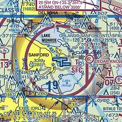
| Sectional chart |
|---|
|
CAUTION: Diagram may not be current
 Download PDF
of official airport diagram from the FAA
| Airport distance calculator |
|---|
|
|
| Sunrise and sunset |
|---|
|
Times for 10-Jun-2026
| | Local
(UTC-4) | | Zulu
(UTC) |
|---|
| Morning civil twilight | | 06:00 | | 10:00 |
| Sunrise | | 06:27 | | 10:27 |
| Sunset | | 20:22 | | 00:22 |
| Evening civil twilight | | 20:48 | | 00:48 |
|
| Current date and time |
|---|
| Zulu (UTC) | 10-Jun-2026 23:22:29 |
|---|
| Local (UTC-4) | 10-Jun-2026 19:22:29 |
|---|
|
| METAR |
|---|
| KSFB | 102253Z 10009KT 10SM CLR 29/21 A3000 RMK AO2 SLP157 T02890211
|
KORL
15nm S | 102253Z 12009KT 10SM FEW027 28/23 A3000 RMK AO2 SLP162 T02830228
|
KDED
18nm N | 102230Z AUTO 09013KT 10SM SCT032 30/21 A3001 RMK AO2 LTG DSNT S T02960214
|
|
| TAF |
|---|
| KSFB | 101735Z 1018/1118 10013KT P6SM VCTS SCT050CB SCT070 BKN200 FM110100 14005KT P6SM FEW050 SCT070 SCT140 FM111500 14004KT P6SM SCT025 SCT040 SCT060 FM111700 11006KT P6SM VCSH SCT050 SCT130 SCT250
|
|
| NOTAMs |
|---|
NOTAMs are issued by the DoD/FAA and will open in a separate window not controlled by AirNav.
|
|


