FAA INFORMATION EFFECTIVE 09 JULY 2026
Location
| FAA Identifier: | ORL |
| Lat/Long: | 28-32-43.6620N 081-19-58.5480W
28-32.727700N 081-19.975800W
28.5454617,-81.3329300
(estimated) |
| Elevation: | 112.5 ft. / 34.3 m (surveyed) |
| Variation: | 06W (2015) |
| From city: | 3 miles E of ORLANDO, FL |
| Time zone: | UTC -4 (UTC -5 during Standard Time) |
| Zip code: | 32807 |
Airport Operations
| Airport use: | Open to the public |
| Activation date: | 04/1940 |
| Control tower: | yes |
| ARTCC: | JACKSONVILLE CENTER |
| FSS: | SAINT PETERSBURG FLIGHT SERVICE STATION |
| NOTAMs facility: | ORL (NOTAM-D service available) |
| Attendance: | 0600-2200 |
| Wind indicator: | lighted, LGTD WIND CONES LCTD NEAR RWY ENDS. |
| Segmented circle: | no |
| Lights: | ATC-CTL. WHEN ATCT CLSD ACTVT MALSR RWY 07; REIL RWY 25, 13 & 31; HIRL RWY 07/25 & 13/31; TWY LGTS - CTAF. PAPI RWY 7, 25, 13 & 31 OPR CONS. |
| Beacon: | white-green (lighted land airport)
Operates sunset to sunrise. |
| International operations: | US CUSTOMS USER FEE ARPT. |
Airport Communications
| CTAF: | 118.7 |
| UNICOM: | 122.95 |
| ATIS: | 127.25 |
| WX ASOS: | 127.25 (407-658-6753) |
| EXECUTIVE GROUND: | 121.4 239.0 [0700-2200] |
| EXECUTIVE TOWER: | 118.7 239.0 [0700-2200] |
| ORLANDO APPROACH: | 119.4 ;181-310 5500 FT & BLW 119.4 ;RWY 07 119.4 ;SOUTHWEST 120.15 ;181-359 ABV 5500 FT 124.8 ;000-180 ABV 5000 FT 125.225 ;061-180 4500 FT & BLW 125.225 ;RWY 25 135.3 ;311-060 5500 FT & BLW |
| ORLANDO DEPARTURE: | 119.4 ;181-310 5500 FT & BLW 119.4 ;RWY 07 119.4 ;SOUTHWEST 120.15 ;181-359 ABV 5500 FT 124.8 ;000-180 ABV 5000 FT 125.225 ;061-180 4500 FT & BLW 125.225 ;RWY 25 135.3 ;311-060 5500 FT & BLW |
| CLEARANCE DELIVERY: | 119.775 ;FOR CD OR TO CNL IFR WHEN A 128.45 |
| ALYNA STAR: | 124.8 |
| EMERG: | 121.5 243.0 |
| IC: | 119.4 ;RWY 07 124.8 ;000-180 ABV 5000 FT 125.225 ;RWY 25 |
| JAFAR STAR: | 134.05 |
| JOKRS STAR: | 134.05 |
| LEESE STAR: | 128.675 134.05 |
| MINEE STAR: | 134.05 |
| MUNGI STAR: | 128.375 |
| NYTES DP: | 125.225 |
| PRICY STAR: | 134.05 |
| SHREK STAR: | 128.675 134.05 |
| TOLLZ DP: | 119.4 |
| TTHOR STAR: | 118.85 125.225 |
| WX ASOS at MCO (7 nm S): | PHONE 407-270-2241 |
| WX ASOS at SFB (15 nm N): | 125.975 (407-321-9384) |
| WX AWOS-3PT at ISM (16 nm S): | PHONE 407-847-0533 |
Nearby radio navigation aids
| VOR radial/distance | | VOR name | | Freq | | Var |
|---|
| ORL at field | | ORLANDO VORTAC | | 112.20 | | 00E |
Airport Services
| Fuel available: | 100 100LL JET-A |
| Parking: | hangars and tiedowns |
| Airframe service: | MAJOR |
| Powerplant service: | MAJOR |
| Bottled oxygen: | LOW |
| Bulk oxygen: | NONE |
Runway Information
Runway 7/25
| Dimensions: | 6004 x 150 ft. / 1830 x 46 m |
| Surface: | asphalt/grooved, in fair condition |
| Weight bearing capacity: | | PCN 55 /F/A/W/T | | Single wheel: | 45.0 | | Double wheel: | 100.0 | | Double tandem: | 115.0 |
|
| Runway edge lights: | high intensity |
| RUNWAY 7 | | RUNWAY 25 |
| Latitude: | 28-32.569702N | | 28-32.961545N |
| Longitude: | 081-20.356428W | | 081-19.325902W |
| Elevation: | 105.6 ft. | | 109.7 ft. |
| Traffic pattern: | left | | right |
| Runway heading: | 073 magnetic, 067 true | | 253 magnetic, 247 true |
| Declared distances: | TORA:6004 TODA:6004 ASDA:5604 LDA:5604 | | TORA:6004 TODA:6004 ASDA:6004 LDA:6004 |
| Markings: | precision, in fair condition | | precision, in fair condition |
| Visual slope indicator: | 4-light PAPI on left (3.00 degrees glide path) | | 4-light PAPI on right (3.00 degrees glide path) |
| RVR equipment: | touchdown | | rollout |
| Approach lights: | MALSR: 1,400 foot medium intensity approach lighting system with runway alignment indicator lights | | |
| Runway end identifier lights: | | | yes |
| Touchdown point: | yes, no lights | | yes, no lights |
| Instrument approach: | ILS | | ILS/DME |
| Obstructions: | 43 ft. trees, 1670 ft. from runway, 230 ft. left of centerline, 34:1 slope to clear | | none |
Runway 13/31
| Dimensions: | 4625 x 100 ft. / 1410 x 30 m |
| Surface: | asphalt/grooved, in fair condition |
| Weight bearing capacity: | | PCN 35 /F/B/X/T | | Single wheel: | 35.0 | | Double wheel: | 60.0 |
|
| Runway edge lights: | high intensity |
| RUNWAY 13 | | RUNWAY 31 |
| Latitude: | 28-32.927983N | | 28-32.428915N |
| Longitude: | 081-20.477463W | | 081-19.823680W |
| Elevation: | 104.0 ft. | | 109.0 ft. |
| Traffic pattern: | left | | right |
| Runway heading: | 137 magnetic, 131 true | | 317 magnetic, 311 true |
| Markings: | basic, in fair condition | | basic, in fair condition |
| Visual slope indicator: | 2-light PAPI on left (3.00 degrees glide path) | | 2-light PAPI on left (3.00 degrees glide path) |
| Runway end identifier lights: | yes | | yes |
| Touchdown point: | yes, no lights | | yes, no lights |
| Obstructions: | 49 ft. trees, 1890 ft. from runway, 150 ft. right of centerline, 34:1 slope to clear | | 53 ft. tree, 1303 ft. from runway, 15 ft. right of centerline, 20:1 slope to clear |
Airport Ownership and Management from official FAA records
| Ownership: | Publicly-owned |
| Owner: | GREATER ORLANDO AVIATION AUTH
1 JEFF FUQUA BLVD
ORLANDO, FL 32827-4399
Phone 407-825-1699
ARPT MAIN OFC CTC 407-825-1699; 24/7 EMERG CTC 407 579-5088. |
| Manager: | JUDITH-ANN JARRETTE
365 RICKENBACKER DR
ORLANDO, FL 32803
Phone 407-825-1683 |
Additional Remarks
| - | PPR FOR ACFT OVER 100000 LBS; CTC AMGR 407-825-1681. |
| - | CBP OFC LCTD ONSITE PPR. CTC 407 825-5102. BE ALERT: CBP BOX LCTD ON EAST RAMP IS RSTRD. |
| - | EXECUTIVE ARPT VFR ARR/DEP EXERCISE CAUTION DUE TO SMALL & HVY TURBO-JET ACFT TRANSITING ARPT TFC AREA 2000 FT & ABOVE ON APCH TO ORLANDO INTL 5.6 NM S. |
| - | TWY E BTN TWY D & E5 IS NON MOVEMENT AREA. |
| - | CALL BOXES MKD NEAR ENTRANCES TO W, N & E RAMPS. |
| - | 24 HR ADVN NOTICE OR IMT REPORTING UPON LDG FOR ACFT EQUIPPED WITH WEATHER MODIFICATION OR GEOENGINEERING EQUIP CTC ARPT OPS407-579-5088 |
| - | LGTD BRIDGE HWY LCTD 0.5 NM S OF ARPT MAY GIVE FALSE INDCN OF APCH TO RWY 07 & 31. |
| - | WILDLIFE INVOF ARPT. |
| - | FOR CD OR TO CNL IFR WHEN ATCT IS CLSD, CTC ORLANDO APCH AT 407-852-7500. |
| - | NOISE SENSITIVE ARPT. WHEN ATCT CLSD RWY 07 IS PREF NOISE ABATEMENT RWY WX PMTG. VOLUNTARY RESTRAINT FROM TGL OPS 2300 - 0700. |
| - | BANNER TOWING OPS S RWY 07/25. |
| - | ACFT TAXI ON S HALF OF THE W RAMP RESTR TO ADG1. |
| - | ATC RADAR REQ WHEN ORL ILS RWY 7 & MCO ILS RWY 17 & 18R SIMULTANEOUS OPS ARE CONDUCTED. |
Instrument Procedures
NOTE: All procedures below are presented as PDF files. If you need a reader for these files, you should download the free Adobe Reader.NOT FOR NAVIGATION. Please procure official charts for flight.
FAA instrument procedures published for use from 09 July 2026 at 0901Z to 06 August 2026 at 0900Z.
STARs - Standard Terminal Arrivals |
|---|
| ALYNA FOUR (RNAV) **NEW** | |
download (275KB) |
| JAFAR THREE (RNAV) **NEW** | |
2 pages:
[1] [2] (346KB) |
| JOKRS FOUR (RNAV) **NEW** | |
2 pages:
[1] [2] (331KB) |
| LEESE THREE **NEW** | |
2 pages:
[1] [2] (254KB) |
| MINEE SIX **NEW** | |
2 pages:
[1] [2] (325KB) |
| MUNGI ONE (RNAV) **NEW** | |
2 pages:
[1] [2] (501KB) |
| PRICY FIVE (RNAV) **NEW** | |
2 pages:
[1] [2] (402KB) |
| PRICY FIVE (RNAV), CONT.2 **NEW** | |
download (151KB) |
| SHREK TWO (RNAV) **NEW** | |
download (189KB) |
| SLOAO ONE (RNAV) **NEW** | |
download (162KB) |
| TTHOR THREE (RNAV) **NEW** | |
2 pages:
[1] [2] (333KB) |
IAPs - Instrument Approach Procedures |
|---|
| ILS OR LOC RWY 07 **CHANGED** | |
download (289KB) |
| ILS OR LOC RWY 25 **CHANGED** | |
download (268KB) |
| RNAV (GPS) RWY 07 **CHANGED** | |
download (257KB) |
| RNAV (GPS) RWY 25 **CHANGED** | |
download (226KB) |
| NOTE: Special Alternate Minimums apply | |
download (149KB) |
Departure Procedures |
|---|
| NYTES TWO (RNAV) | |
download (131KB) |
| TOLLZ TWO (RNAV) | |
download (140KB) |
| NOTE: Special Take-Off Minimums/Departure Procedures apply | |
download (417KB) |
Other nearby airports with instrument procedures:
KMCO - Orlando International Airport (7 nm S)
KSFB - Orlando Sanford International Airport (15 nm N)
X04 - Orlando Apopka Airport (16 nm NW)
KISM - Kissimmee Gateway Airport (16 nm S)
X21 - Arthur Dunn Air Park (27 nm E)
|
|

Road maps at:
MapQuest
Bing
Google
| Aerial photo |
|---|
WARNING: Photo may not be current or correct
 Photo courtesy of Russell Aerial Photo
Photo taken 24-Jan-2018
looking south from 8,000 ft.
Photo courtesy of Russell Aerial Photo
Photo taken 24-Jan-2018
looking south from 8,000 ft.
Do you have a better or more recent aerial photo of Orlando Executive Airport that you would like to share? If so, please send us your photo.
|
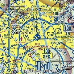
| Sectional chart |
|---|
|
CAUTION: Diagram may not be current
 Download PDF
of official airport diagram from the FAA
| Airport distance calculator |
|---|
|
|
| Sunrise and sunset |
|---|
|
Times for 26-Jul-2026
| | Local
(UTC-4) | | Zulu
(UTC) |
|---|
| Morning civil twilight | | 06:19 | | 10:19 |
| Sunrise | | 06:45 | | 10:45 |
| Sunset | | 20:19 | | 00:19 |
| Evening civil twilight | | 20:45 | | 00:45 |
|
| Current date and time |
|---|
| Zulu (UTC) | 26-Jul-2026 12:59:04 |
|---|
| Local (UTC-4) | 26-Jul-2026 08:59:04 |
|---|
|
| METAR |
|---|
| KORL | 261253Z 32006KT 10SM CLR 29/24 A3001 RMK AO2 SLP165 T02940239
|
KMCO
8nm S | 261253Z 34008KT 10SM FEW040 FEW250 29/24 A3001
|
KSFB
15nm NE | 261153Z 30008KT 10SM CLR 27/25 A3000
|
KISM
17nm S | 261156Z 00000KT 10SM CLR 26/24 A3002 RMK AO2 SLP168 P0001 60001 70001 T02560239 10256 20239 51010 $
|
|
| TAF |
|---|
KMCO
8nm S | 261120Z 2612/2718 VRB05KT P6SM FEW250 FM261400 30007KT P6SM SCT040 SCT250 FM261800 26008KT P6SM VCTS SCT045CB BKN200 TEMPO 2620/2623 3SM TSRA BKN035CB FM270200 24005KT P6SM SCT060 BKN120 FM271400 28007KT P6SM VCSH SCT030 SCT100
|
KSFB
15nm NE | 260526Z 2606/2706 VRB04KT P6SM FEW250 FM261400 32006KT P6SM SCT040 SCT250 FM261700 22008KT P6SM VCTS SCT045CB BKN200 FM270200 23004KT P6SM SCT060 BKN120
|
KISM
17nm S | 261120Z 2612/2712 VRB04KT P6SM FEW250 FM261400 31006KT P6SM SCT040 SCT250 FM261800 26008KT P6SM VCTS SCT045CB BKN200 TEMPO 2620/2623 3SM TSRA BKN035CB FM270200 25004KT P6SM SCT060 BKN120
|
|
| NOTAMs |
|---|
NOTAMs are issued by the DoD/FAA and will open in a separate window not controlled by AirNav.
|
|


