FAA INFORMATION EFFECTIVE 14 MAY 2026
Location
| FAA Identifier: | SIV |
| Lat/Long: | 39-06-52.9650N 087-26-53.9850W
39-06.882750N 087-26.899750W
39.1147125,-87.4483292
(estimated) |
| Elevation: | 539.2 ft. / 164.3 m (surveyed) |
| Variation: | 02W (1995) |
| From city: | 3 miles NW of SULLIVAN, IN |
| Time zone: | UTC -4 (UTC -5 during Standard Time) |
| Zip code: | 47882 |
Airport Operations
| Airport use: | Open to the public |
| Activation date: | 12/1966 |
| Control tower: | no |
| ARTCC: | INDIANAPOLIS CENTER |
| FSS: | TERRE HAUTE FLIGHT SERVICE STATION |
| NOTAMs facility: | HUF (NOTAM-D service available) |
| Attendance: | MON-SAT 0800-1700, ALL SUN 1300-1700
UNATNDD JULY 4TH, MEMORIAL, THANKSGIVING, CHRISTMAS & NEW YEARS DAY. |
| Pattern altitude: | 1339.2 ft. MSL |
| Wind indicator: | lighted |
| Segmented circle: | no |
| Lights: | ACTVT REILS RWYS 18 & 36; MIRL RWY 18/36 - CTAF. PAPI RWY 18 & 36 OPR CONSLY. |
| Beacon: | white-green (lighted land airport)
24 HR. |
Airport Communications
| CTAF/UNICOM: | 122.8 |
| HULMAN APPROACH: | 135.35 [0530-0000 SUN-FRI, 0530-2345 SAT.] |
| HULMAN DEPARTURE: | 135.35 [0530-0000 SUN-FRI, 0530-2345 SAT.] |
| WX AWOS-3 at RSV (11 nm SW): | 120.50 (618-586-2772) |
Nearby radio navigation aids
| VOR radial/distance | | VOR name | | Freq | | Var |
|---|
| TTHr200/24.3 | | TERRE HAUTE VORTAC | | 115.30 | | 02E |
| OOMr269/38.9 | | HOOSIER VORTAC | | 110.20 | | 02W |
Airport Services
| Fuel available: | 100LL JET-A |
| Parking: | hangars and tiedowns |
| Airframe service: | MINOR |
| Powerplant service: | MINOR |
Runway Information
Runway 18/36
| Dimensions: | 4359 x 75 ft. / 1329 x 23 m |
| Surface: | asphalt/rubberized friction seal coat, in good condition |
| Weight bearing capacity: | | Single wheel: | 27.0 | | Double wheel: | 35.0 |
|
| Runway edge lights: | medium intensity |
| RUNWAY 18 | | RUNWAY 36 |
| Latitude: | 39-07.241723N | | 39-06.523740N |
| Longitude: | 087-26.894360W | | 087-26.905373W |
| Elevation: | 536.9 ft. | | 534.6 ft. |
| Traffic pattern: | left | | left |
| Runway heading: | 183 magnetic, 181 true | | 003 magnetic, 001 true |
| Markings: | nonprecision, in good condition | | nonprecision, in good condition |
| Visual slope indicator: | 2-light PAPI on left (3.00 degrees glide path) | | 2-light PAPI on left (3.00 degrees glide path) |
| Runway end identifier lights: | yes | | yes |
| Touchdown point: | yes, no lights | | yes, no lights |
| Obstructions: | 10 ft. crops, 380 ft. from runway, 18:1 slope to clear | | 10 ft. crops, 380 ft. from runway, 18:1 slope to clear |
Airport Ownership and Management from official FAA records
| Ownership: | Publicly-owned |
| Owner: | SULLIVAN COUNTY BOAC
P.O. BOX 351
SULLIVAN, IN 47882
Phone 812-268-6959 |
| Manager: | PAT HARMON
2001 N CR 200 W
SULLIVAN, IN 47882
Phone 812-268-6959 |
Additional Remarks
| - | 153 FT TWR 6600 FT SE. |
| - | MOORED BALLOON 2 MI E 1600 FT & BLW. |
| - | FOR CD CTC HULMAN APCH AT 812-877-7581. |
Instrument Procedures
NOTE: All procedures below are presented as PDF files. If you need a reader for these files, you should download the free Adobe Reader.NOT FOR NAVIGATION. Please procure official charts for flight.
FAA instrument procedures published for use from 14 May 2026 at 0901Z to 11 June 2026 at 0900Z.
IAPs - Instrument Approach Procedures |
|---|
| RNAV (GPS) RWY 18 | |
download (222KB) |
| RNAV (GPS) RWY 36 | |
download (233KB) |
| NOTE: Special Take-Off Minimums/Departure Procedures apply | |
download (164KB) |
Other nearby airports with instrument procedures:
KRSV - Crawford County Airport (11 nm SW)
KHUF - Terre Haute Regional Airport (21 nm N)
KLWV - Lawrenceville-Vincennes International Airport (22 nm S)
3I3 - Sky King Airport (26 nm N)
0I2 - Brazil Clay County Airport/Charles B Hall Field (27 nm NE)
|
|

Road maps at:
MapQuest
Bing
Google
| Aerial photo |
|---|
WARNING: Photo may not be current or correct

Do you have a better or more recent aerial photo of Sullivan County Airport that you would like to share? If so, please send us your photo.
|
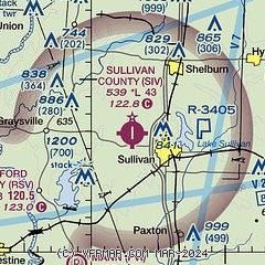
| Sectional chart |
|---|
|
| Airport distance calculator |
|---|
|
|
| Sunrise and sunset |
|---|
|
Times for 05-Jun-2026
| | Local
(UTC-4) | | Zulu
(UTC) |
|---|
| Morning civil twilight | | 05:53 | | 09:53 |
| Sunrise | | 06:25 | | 10:25 |
| Sunset | | 21:11 | | 01:11 |
| Evening civil twilight | | 21:43 | | 01:43 |
|
| Current date and time |
|---|
| Zulu (UTC) | 05-Jun-2026 23:29:29 |
|---|
| Local (UTC-4) | 05-Jun-2026 19:29:29 |
|---|
|
| METAR |
|---|
KRSV
11nm SW | 052315Z AUTO 21013G18KT 10SM CLR 29/17 A2993 RMK AO2
|
KHUF
21nm N | 052253Z AUTO 20013G21KT 10SM CLR 28/17 A2993 RMK AO2 SLP132 T02830172
|
KLWV
22nm S | 052253Z AUTO 21015KT 10SM CLR 29/16 A2995 RMK AO2 SLP138 T02940161
|
|
| TAF |
|---|
KHUF
21nm N | 051728Z 0518/0618 19013G20KT P6SM SCT050 BKN090 FM060000 19008KT P6SM SCT050 BKN090 FM061000 22009KT P6SM BKN070 PROB30 0610/0614 5SM -SHRA BKN050 FM061600 23010KT P6SM VCSH BKN035
|
|
| NOTAMs |
|---|
NOTAMs are issued by the DoD/FAA and will open in a separate window not controlled by AirNav.
|
|

