FAA INFORMATION EFFECTIVE 14 MAY 2026
Location
| FAA Identifier: | LWV |
| Lat/Long: | 38-45-51.4000N 087-36-19.8000W
38-45.856667N 087-36.330000W
38.7642778,-87.6055000
(estimated) |
| Elevation: | 429.8 ft. / 131.0 m (surveyed) |
| Variation: | 01W (1990) |
| From city: | 3 miles NE of LAWRENCEVILLE, IL |
| Time zone: | UTC -5 (UTC -6 during Standard Time) |
| Zip code: | 62439 |
Airport Operations
| Airport use: | Open to the public |
| Activation date: | 10/1943 |
| Control tower: | no |
| ARTCC: | INDIANAPOLIS CENTER |
| FSS: | SAINT LOUIS FLIGHT SERVICE STATION |
| NOTAMs facility: | LWV (NOTAM-D service available) |
| Attendance: | MON-FRI 0700-1800, ALL SAT-SUN 0900-1700 |
| Pattern altitude: | RWY 09/27 & 18/36 900 FT AGL PWRD ACFT; RWY 04U/22U 500 FT AGL MAX ULTRALIGHTS. |
| Wind indicator: | lighted |
| Segmented circle: | no
TRAFFIC PATTERN INDICATORS ON SOD RUNWAY 4U/22U |
| Lights: | ACTVT ODALS RWY 27; REIL RWY 9, 27, 18 & 36; PAPI RWY 36; MIRL RWY 09/27 - CTAF. MIRL RWY 18/36 PRESET ON LOW INTST TO INCR INTST - CTAF. |
| Beacon: | white-green (lighted land airport)
Operates sunset to sunrise. |
Airport Communications
| CTAF/UNICOM: | 122.8 |
| WX ASOS: | 118.0 (618-943-5252) |
| EVANSVILLE APPROACH: | 125.6 |
| EVANSVILLE DEPARTURE: | 125.6 |
| WX AWOS-3 at AJG (11 nm SW): | 134.900 (618-948-2184) |
| WX AWOS-3 at RSV (15 nm N): | 120.50 (618-586-2772) |
- APCH/DEP SVC PRVDD BY INDIANAPOLIS ARTCC ON FREQS 128.3/291.625 (EVANSVILLE RCAG) WHEN EVANSVILLE APCH CTL CLSD.
Nearby radio navigation aids
| NDB name | | Hdg/Dist | | Freq | | Var | | ID |
|---|
| OLNEY | | 087/26.7 | | 272 | | 03W | | OLY | --- .-.. -.-- |
Airport Services
| Fuel available: | 100LL JET-A |
| Parking: | hangars and tiedowns |
| Airframe service: | NONE |
| Powerplant service: | NONE |
| Bottled oxygen: | NONE |
| Bulk oxygen: | NONE |
Runway Information
Runway 18/36
| Dimensions: | 5199 x 100 ft. / 1585 x 30 m |
| Surface: | asphalt, in good condition |
| Weight bearing capacity: | | Single wheel: | 75.0 | | Double wheel: | 100.0 | | Double tandem: | 180.0 |
|
| Runway edge lights: | medium intensity |
| RUNWAY 18 | | RUNWAY 36 |
| Latitude: | 38-46.079380N | | 38-45.222927N |
| Longitude: | 087-36.067280W | | 087-36.057430W |
| Elevation: | 429.4 ft. | | 424.9 ft. |
| Traffic pattern: | left | | left |
| Runway heading: | 180 magnetic, 179 true | | 000 magnetic, 359 true |
| Markings: | nonprecision, in good condition | | nonprecision, in good condition |
| Visual slope indicator: | pulsating/steady burning VASI on left (3.00 degrees glide path)
PVASI UNUSBL BYD 8 DEGREES LEFT OF CNTRLN & BYD 6 DEGREES RIGHT OF CNTRLN. | | 4-light PAPI on left (3.00 degrees glide path) |
| Runway end identifier lights: | yes | | yes |
| Touchdown point: | yes, no lights | | yes, no lights |
Runway 9/27
| Dimensions: | 5198 x 100 ft. / 1584 x 30 m |
| Surface: | asphalt, in good condition |
| Weight bearing capacity: | | Single wheel: | 75.0 | | Double wheel: | 100.0 | | Double tandem: | 180.0 |
|
| Runway edge lights: | medium intensity |
| RUNWAY 9 | | RUNWAY 27 |
| Latitude: | 38-46.058647N | | 38-46.067293N |
| Longitude: | 087-37.145340W | | 087-36.051642W |
| Elevation: | 425.6 ft. | | 429.5 ft. |
| Traffic pattern: | left | | left |
| Runway heading: | 090 magnetic, 089 true | | 270 magnetic, 269 true |
| Markings: | nonprecision, in good condition | | nonprecision, in good condition |
| Visual slope indicator: | pulsating/steady burning VASI on left (3.00 degrees glide path)
PVASI UNUSBL BYD 8 DEGREES LEFT OF CNTRLN & BYD 6 DEGREES RIGHT OF CNTRLN. | | 4-light PAPI on left (3.00 degrees glide path) |
| Approach lights: | | | ODALS: omnidirectional approach lighting system |
| Runway end identifier lights: | yes | | yes |
| Touchdown point: | yes, no lights | | yes, no lights |
Runway 4U/22U
| Dimensions: | 1000 x 200 ft. / 305 x 61 m |
| Surface: | turf, in fair condition |
| RUNWAY 4U | | RUNWAY 22U |
| Traffic pattern: | left | | right |
Airport Ownership and Management from official FAA records
| Ownership: | Publicly-owned |
| Owner: | BI-STATE AUTHORITY
13608 HANGAR RD
LAWRENCEVILLE, IL 62439
Phone 618-943-5733
JOINT OWNED - CITY OF VINCENNES IN & LAWRENCEVILLE IL. |
| Manager: | DEVON HILL
13608 HANGAR RD
LAWRENCEVILLE, IL 62439
Phone 618-943-5733
812-881-7042. |
Additional Remarks
| - | GLIDER ACTVTY SR-SS. RYS 09/27 & 18/36 HAVE LEFT HAND TFC PATTERN FOR GLIDER ACFT. |
| - | BE ALERT; ODALS FOR RY 27 ARE IN OPERATION SIMULTANEOUSLY WITH REILS ON RY 18. |
| - | FOR CD WHEN RCO 125.6 OTS, CTC EVANSVILLE APCH AT 812-436-4689, WHEN APCH CLSD CTC INDIANAPOLIS ARTCC AT 317-247-2411. |
Instrument Procedures
NOTE: All procedures below are presented as PDF files. If you need a reader for these files, you should download the free Adobe Reader.NOT FOR NAVIGATION. Please procure official charts for flight.
FAA instrument procedures published for use from 14 May 2026 at 0901Z to 11 June 2026 at 0900Z.
IAPs - Instrument Approach Procedures |
|---|
| RNAV (GPS) RWY 09 | |
download (281KB) |
| RNAV (GPS) RWY 18 | |
download (275KB) |
| RNAV (GPS) RWY 27 | |
download (301KB) |
| RNAV (GPS) RWY 36 | |
download (287KB) |
| NOTE: Special Alternate Minimums apply | |
download (141KB) |
| NOTE: Special Take-Off Minimums/Departure Procedures apply | |
download (353KB) |
Other nearby airports with instrument procedures:
KAJG - Mount Carmel Municipal Airport (11 nm SW)
KRSV - Crawford County Airport (15 nm N)
KSIV - Sullivan County Airport (22 nm N)
KDCY - Daviess County Airport (23 nm E)
KOLY - Olney-Noble Airport (27 nm W)
|
|

Road maps at:
MapQuest
Bing
Google
| Aerial photo |
|---|
WARNING: Photo may not be current or correct

Do you have a better or more recent aerial photo of Lawrenceville-Vincennes International Airport that you would like to share? If so, please send us your photo.
|
| Sectional chart |
|---|
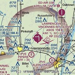
|
| Airport distance calculator |
|---|
|
|
| Sunrise and sunset |
|---|
|
Times for 20-May-2026
| | Local
(UTC-5) | | Zulu
(UTC) |
|---|
| Morning civil twilight | | 05:05 | | 10:05 |
| Sunrise | | 05:35 | | 10:35 |
| Sunset | | 19:59 | | 00:59 |
| Evening civil twilight | | 20:29 | | 01:29 |
|
| Current date and time |
|---|
| Zulu (UTC) | 20-May-2026 12:57:27 |
|---|
| Local (UTC-5) | 20-May-2026 07:57:27 |
|---|
|
| METAR |
|---|
| KLWV | 201253Z AUTO 34007KT 2 1/2SM RA BR BKN008 BKN020 OVC026 14/14 A3015 RMK AO2 RAB1156 SLP209 P0024 T01440139
|
KAJG
11nm SW | 201235Z AUTO 32008KT 10SM -DZ BKN008 OVC019 16/15 A3016 RMK AO2 T01570154
|
KRSV
15nm N | 201235Z AUTO 33005KT 9SM -RA BKN020 OVC049 15/14 A3015 RMK AO2
|
|
| TAF |
|---|
KHUF
43nm N | 201120Z 2012/2112 35008KT P6SM VCSH OVC025 FM201500 02009KT P6SM VCSH OVC015 FM202300 03008KT P6SM OVC040
|
KEVV
43nm S | 201120Z 2012/2112 35008KT 6SM -SHRA OVC012 TEMPO 2012/2013 4SM SHRA OVC007 FM201300 36007KT 4SM SHRA BR OVC007 TEMPO 2013/2017 2SM +SHRA BR OVC005 FM201800 01007KT 6SM BR OVC007 PROB30 2018/2023 4SM -SHRA FM210000 02006KT P6SM OVC009
|
KHNB
44nm SE | 201120Z 2012/2112 02005KT P6SM -RA BKN009 OVC012 FM201400 35005KT 4SM -RA BR OVC008 FM202200 02008KT P6SM OVC009
|
|
| NOTAMs |
|---|
NOTAMs are issued by the DoD/FAA and will open in a separate window not controlled by AirNav.
|
|

