FAA INFORMATION EFFECTIVE 16 APRIL 2026
Location
| FAA Identifier: | SNA |
| Lat/Long: | 33-40-32.3830N 117-52-05.6390W
33-40.539717N 117-52.093983W
33.6756619,-117.8682331
(estimated) |
| Elevation: | 55.9 ft. / 17.0 m (surveyed) |
| Variation: | 12E (2015) |
| From city: | 4 miles S of SANTA ANA, CA |
| Time zone: | UTC -7 (UTC -8 during Standard Time) |
| Zip code: | 92707 |
Airport Operations
| Airport use: | Open to the public |
| Activation date: | 11/1941 |
| Control tower: | yes |
| ARTCC: | LOS ANGELES CENTER |
| FSS: | RIVERSIDE FLIGHT SERVICE STATION |
| NOTAMs facility: | SNA (NOTAM-D service available) |
| Attendance: | CONTINUOUS |
| Wind indicator: | lighted |
| Segmented circle: | yes |
| Lights: | WHEN ATCT CLSD ACTVT MALSR RY 20R & PAPI RYS 02L & 20R - CTAF. |
| Beacon: | white-green (lighted land airport)
Operates sunset to sunrise. |
| Landing fee: | no, OVERNIGHT TIE-DOWN FEE. |
| Fire and rescue: | ARFF index C |
| International operations: | US CUSTOMS USER FEE ARPT. |
Airport Communications
| CTAF: | 126.8 |
| UNICOM: | 122.95 |
| WX ASOS: | PHONE 714-338-2330 |
| JOHN WAYNE GROUND: | 120.8 132.25 [0615-2300] |
| JOHN WAYNE TOWER: | 119.9 ;RWY 02R/20L 126.8 ;RWY 02L/20R 343.625 128.35 [0615-2300] |
| SOCAL APPROACH: | 121.3 |
| SOCAL DEPARTURE: | 128.1 132.7 |
| CLEARANCE DELIVERY: | 118.0 121.85 |
| ANAHEIM DP: | 125.35 ;RWY 20R HECTOR OR LAKE HUGHE 133.85 ;RWY 02L, 02R, HECTOR, LAKE H 133.85 ;RWY 2L/R, HECTOR, LAKE HUGHE |
| CHANNEL DP: | 128.1 |
| CLASS C: | 121.3 ;315-045 SNA 124.1 ;045-130 SNA 125.35 ;190-315 SLI 127.2 ;190-315 SNA ABV 3000 FT 128.1 ; 130-190 SNA 132.7 ;045-130 SNA |
| D-ATIS: | 126.0 |
| DSNEE STAR: | 134.0 |
| EMMLN STAR: | 127.0 |
| FINZZ DP: | 128.1 |
| HAWWC DP: | 125.35 |
| HHERO DP: | 128.1 |
| HOBOW DP: | 133.85 |
| IC: | 126.8 ;RWY 02L/20R |
| KAYOH STAR: | 133.85 |
| MIKAA DP: | 133.85 |
| MUSEL DP: | 128.1 |
| OHSEA STAR: | 127.4 |
| PIGGN DP: | 128.1 ;RWY 20R 133.85 ;RWY 02L |
| ROOBY STAR: | 134.0 |
| RUKKI STAR: | 127.4 |
| STAYY DP: | 128.1 |
| TANDY STAR: | 127.4 |
| WX ASOS at FUL (13 nm NW): | PHONE 714-870-1372 |
| WX ASOS at LGB (17 nm NW): | PHONE 562-247-0378 |
| WX AWOS-3PT at AJO (19 nm NE): | 132.175 (951-340-4764) |
- ASDE-X IN USE. OPERATE TRANSPONDERS WITH ALTITUDE REPORTING MODE AND ADS-B (IF EQUIPPED) ENABLED ON ALL AIRPORT SURFACES.
- DO NOT PUBLISH ON APCH PLATES.
Nearby radio navigation aids
| VOR radial/distance | | VOR name | | Freq | | Var |
|---|
| ELBr256/6.8 | | EL TORO VOR/DME | | 117.20 | | 14E |
| SLIr110/11.3 | | SEAL BEACH VORTAC | | 115.70 | | 15E |
| PDZr214/22.3 | | PARADISE VORTAC | | 112.20 | | 15E |
| POMr174/24.5 | | POMONA VORTAC | | 110.40 | | 15E |
| RALr217/(26.8) | | RIVERSIDE VOR | | 108.60 | | 14E |
| LAXr104/32.1 | | LOS ANGELES VORTAC | | 113.60 | | 15E |
| SXCr042/33.0 | | SANTA CATALINA VORTAC | | 114.15 | | 15E |
| OCNr304/34.5 | | OCEANSIDE VORTAC | | 115.30 | | 15E |
| HDFr246/(34.6) | | HOMELAND VOR | | 112.05 | | 14E |
| SMOr109/35.5 | | SANTA MONICA VOR/DME | | 110.80 | | 15E |
Airport Services
| Fuel available: | 100LL JET-A |
| Parking: | tiedowns |
| Airframe service: | MAJOR |
| Powerplant service: | MAJOR |
| Bottled oxygen: | HIGH/LOW |
Runway Information
Runway 2L/20R
| Dimensions: | 5700 x 150 ft. / 1737 x 46 m |
| Surface: | asphalt/grooved, in good condition |
| Weight bearing capacity: | | Single wheel: | 70.0 | | Double wheel: | 200.0 | | Double tandem: | 300.0 |
|
| Runway edge lights: | high intensity |
| RUNWAY 2L | | RUNWAY 20R |
| Latitude: | 33-40.068505N | | 33-40.899047N |
| Longitude: | 117-52.430042W | | 117-51.903802W |
| Elevation: | 55.9 ft. | | 41.2 ft. |
| Traffic pattern: | left | | right |
| Runway heading: | 016 magnetic, 028 true | | 196 magnetic, 208 true |
| Declared distances: | TORA:5700 TODA:5700 ASDA:5700 LDA:5700 | | TORA:5700 TODA:5700 ASDA:5700 LDA:5700 |
| Markings: | precision, in good condition | | precision, in good condition |
| Visual slope indicator: | 4-light PAPI on left (3.00 degrees glide path) | | 4-light PAPI on left (3.00 degrees glide path) |
| RVR equipment: | rollout | | touchdown |
| Approach lights: | | | MALSR: 1,400 foot medium intensity approach lighting system with runway alignment indicator lights |
| Runway end identifier lights: | no | | no |
| Touchdown point: | yes, no lights | | yes, no lights |
| Instrument approach: | | | ILS/DME |
Runway 2R/20L
| Dimensions: | 2886 x 75 ft. / 880 x 23 m |
| Surface: | asphalt/grooved, in good condition |
| Weight bearing capacity: | | PCN 120/F/B/X/T | | Single wheel: | 25.0 | | Double wheel: | 60.0 |
|
| Runway edge lights: | medium intensity |
| Operational restrictions: | RWY 02R/20L NOT AVBL FOR PART 121/PART 380 OPS WITH SKED PAX CARRYING OPS MORE THAN 9 PAX SEATS AND NON-SKED PAX CARRYING OPS MORE THAN 30 PAX SEATS. RWY 02R/20L CLSD WHEN ATCT CLSD. |
| RUNWAY 2R | | RUNWAY 20L |
| Latitude: | 33-40.439938N | | 33-40.860450N |
| Longitude: | 117-52.083090W | | 117-51.816668W |
| Elevation: | 52.0 ft. | | 39.7 ft. |
| Traffic pattern: | right | | left |
| Runway heading: | 016 magnetic, 028 true | | 196 magnetic, 208 true |
| Markings: | basic, in good condition | | basic, in good condition |
| Visual slope indicator: | | | 4-light PAPI on left (3.00 degrees glide path) |
| Runway end identifier lights: | no | | yes |
| Touchdown point: | yes, no lights | | yes, no lights |
| Obstructions: | none | | 15 ft. bldg, lighted, 500 ft. from runway, 115 ft. left of centerline, 20:1 slope to clear |
Airport Ownership and Management from official FAA records
| Ownership: | Publicly-owned |
| Owner: | ORANGE COUNTY
3160 AIRWAY AVENUE
COSTA MESA, CA 92626
Phone 949-252-5171 |
| Manager: | CHARLENE V. REYNOLDS
3160 AIRWAY AVE
COSTA MESA, CA 92626
Phone 949-252-5171
RON MCCLELLAN, MGR, AIRSIDE OPNS 949-252-5247. |
Additional Remarks
| A30-20X | RY 20X CREATED TO SUPPORT OJW LDA ASSOCIATED WITH SNA ILS RY 20R. |
| A39-02L/20R | PCR VALUE: 602/F/A/X/T |
| - | MAINTAIN AT OR ABOVE 300 FT AGL UNTIL ESTABLISHED ON FINAL . |
| - | FBO GENERAL AVIATION APRONS LIMITED TO MAX GWT OF 100,000 LBS (DUAL GEAR) AND WITH WINGSPANS LESS THAN 100 FT. GENERAL AVIATION AIRCRAFT PROHIBITED FROM USING ANY PORTION OF THE AIR CARRIER COMMERCIAL RAMP. |
| - | NOISE ABATEMENT PROCEDURES IN EFFECT CTC ARPT NOISE OFFICE (949) 252-5185. |
| - | RWY 02L/20R TPA 1000 FT AGL SMALL ACFT; 1500 FT AGL TURBINE ACFT OVER 12500 LBS; RWY 02R/20L TPA 800 FT AGL SMALL SGL ENG ACFT; 1000 FT AGL TWIN ENG ACFT. |
| - | FOR CD WHEN ATCT CLSD CTC SOCAL APCH AT 800-448-3724. |
| - | ACFT LDG RWY 20L, USE CTN FOR JET BLAST FROM ACFT HLDG BTN RWY 20L AND RWY 20R AT TWY L AND CTN WAKE TURB FROM JET ACFT LDG RWY 20R. |
| - | VFR ACFT: TO AVOID OVERFLIGHT OF RWY 20R, RWY 20L ARRS FLY FINAL AT 15 DEG ANGLE TO RWY; RWY 20L DEPS TURN 15 DEGS LEFT AT DEP END OF RWY. TO AVOID OVERFLIGHT OF RWY 02L, RWY 02R DEPS TURN 15 DEGS RIGHT AT DEP END OF RWY. |
| - | CTC GND CTL PRIOR TO PUSHBACK ON TWY A AND TWY B. |
| - | WHEN ATCT CLSD NO LCL TRNG OR TOUCH & GO OPNS. |
| - | BE ALERT TO BIRDS ON AND IN VICINITY OF ARPT. |
| - | TWY C GWT LMTD 60000 LBS. |
Instrument Procedures
NOTE: All procedures below are presented as PDF files. If you need a reader for these files, you should download the free Adobe Reader.NOT FOR NAVIGATION. Please procure official charts for flight.
FAA instrument procedures published for use from 16 April 2026 at 0901Z to 14 May 2026 at 0900Z.
STARs - Standard Terminal Arrivals |
|---|
| DSNEE SIX (RNAV) | |
2 pages:
[1] [2] (655KB) |
| EMMLN TWO | |
2 pages:
[1] [2] (412KB) |
| KAYOH EIGHT **CHANGED** | |
download (273KB) |
| OHSEA THREE (RNAV) | |
2 pages:
[1] [2] (469KB) |
| OHSEA THREE (RNAV) | |
2 pages:
[1] [2] (469KB) |
| ROOBY THREE (RNAV) | |
2 pages:
[1] [2] (586KB) |
| RUKKI ONE (RNAV) | |
download (269KB) |
| RUKKI ONE (RNAV) | |
download (269KB) |
| TANDY SIX **NEW** | |
2 pages:
[1] [2] (322KB) |
IAPs - Instrument Approach Procedures |
|---|
| ILS OR LOC RWY 20R | |
download (420KB) |
| ILS RWY 20R (SA CAT I) | |
download (376KB) |
| RNAV (RNP) Z RWY 02L | |
download (244KB) |
| RNAV (RNP) Z RWY 20R | |
download (252KB) |
| RNAV (GPS) Y RWY 02L | |
download (241KB) |
| RNAV (GPS) Y RWY 20R | |
download (310KB) |
| LOC BC RWY 02L | |
download (295KB) |
| LDA RWY 20R | |
download (320KB) |
| NOTE: Special Alternate Minimums apply | |
download (140KB) |
Departure Procedures |
|---|
| ANAHEIM ONE | |
2 pages:
[1] [2] (408KB) |
| CHANNEL THREE | |
download (276KB) |
| EL TORO FIVE | |
2 pages:
[1] [2] (397KB) |
| FINZZ THREE (RNAV) | |
download (239KB) |
| HAWWC THREE (RNAV) | |
download (203KB) |
| HHERO THREE (RNAV) | |
download (205KB) |
| HOBOW THREE (RNAV) | |
download (257KB) |
| IRVINE FIVE | |
2 pages:
[1] [2] (441KB) |
| MIKAA ONE (RNAV) | |
download (158KB) |
| MUSEL EIGHT | |
download (261KB) |
| PIGGN THREE (RNAV) | |
2 pages:
[1] [2] (367KB) |
| STAYY FOUR (RNAV) | |
2 pages:
[1] [2] (325KB) |
| NOTE: Special Take-Off Minimums/Departure Procedures apply | |
download (350KB) |
Other nearby airports with instrument procedures:
KSLI - Los Alamitos Army Airfield (11 nm NW)
KFUL - Fullerton Municipal Airport (13 nm NW)
KLGB - Long Beach Airport (Daugherty Field) (17 nm NW)
KAJO - Corona Municipal Airport (19 nm NE)
KCNO - Chino Airport (21 nm NE)
|
|

Road maps at:
MapQuest
Bing
Google
| Aerial photo |
|---|
WARNING: Photo may not be current or correct
 Photo by Trent Thomas
Photo taken 23-Sep-2022
taken flying south at 700 AGL
Photo by Trent Thomas
Photo taken 23-Sep-2022
taken flying south at 700 AGL
Do you have a better or more recent aerial photo of John Wayne/Orange County Airport that you would like to share? If so, please send us your photo.
|
| Sectional chart |
|---|
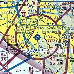
|
CAUTION: Diagram may not be current
 Download PDF
of official airport diagram from the FAA
| Airport distance calculator |
|---|
|
|
| Sunrise and sunset |
|---|
|
Times for 07-May-2026
| | Local
(UTC-7) | | Zulu
(UTC) |
|---|
| Morning civil twilight | | 05:31 | | 12:31 |
| Sunrise | | 05:58 | | 12:58 |
| Sunset | | 19:38 | | 02:38 |
| Evening civil twilight | | 20:05 | | 03:05 |
|
| Current date and time |
|---|
| Zulu (UTC) | 08-May-2026 00:54:48 |
|---|
| Local (UTC-7) | 07-May-2026 17:54:48 |
|---|
|
| METAR |
|---|
| KSNA | 072353Z 23006KT 10SM FEW010 FEW080 20/14 A2995 RMK AO2 SLP140 T02000139 10217 20200 56011
|
KSLI
10nm NW | 072255Z 22010KT 10SM FEW010 23/14 A2990 RMK AO2A SLP128 T02270137
|
KFUL
13nm NW | 072353Z 17008KT 10SM CLR 23/13 A2992 RMK AO2 SLP131 T02330133 10244 20217 56013
|
KLGB
16nm NW | 072353Z 32007KT 10SM CLR 23/14 A2992 RMK AO2 SLP132 T02330139 10244 20200 56016
|
KAJO
19nm NE | 072356Z AUTO 28013G21KT 10SM CLR 26/14 A2991 RMK AO2 SLP122 6//// T02610139 10283 20244 56012
|
|
| TAF |
|---|
| KSNA | 071727Z 0718/0818 21009KT P6SM SKC FM080300 20005KT P6SM SCT012 FM080800 VRB03KT P6SM OVC012 TEMPO 0811/0815 6SM BR OVC008 FM081700 VRB04KT P6SM SCT012
|
KSLI
10nm NW | 072100Z 0721/0903 22011KT 9999 SKC QNH2994INS BECMG 0809/0810 VRB06KT 9000 BR BKN005 OVC010 QNH2998INS BECMG 0816/0817 VRB06KT 9999 NSW SCT005 OVC010 QNH3000INS BECMG 0819/0820 VRB06KT 9999 SCT010 SCT020 QNH3000INS TX22/0721Z TN15/0811Z
|
KLGB
16nm NW | 071721Z 0718/0818 VRB03KT P6SM SKC FM071900 19006KT P6SM SKC FM072100 23007KT P6SM SKC FM080600 VRB03KT P6SM BKN010 FM081100 VRB03KT P6SM BKN018
|
|
| NOTAMs |
|---|
NOTAMs are issued by the DoD/FAA and will open in a separate window not controlled by AirNav.
|
|
FBO, Fuel Providers, and Aircraft Ground Support |
|---|
| | 
Business Name | |
Contact | |
Services / Description | |
Fuel Prices | |
Comments | |
|---|


|
|
ASRI 131.10
949-201-2550
[web site]
[email]

|
|
We are an independent FBO located at John Wayne -- Orange County Airport (SNA). Our friendly staff is available to serve all your ground service needs from fueling, catering, valet to hotel and rental car accommodations. We can be reached via call, text, or email with your reservation details, and we will ensure your travel experience is as effortless as possible.


|
|
|
|

2 read write
|
|

|
|
ASRI 131.575
949-201-2560
[web site]
[email]


|
|
Aviation fuel, Aircraft ground handling, Oxygen service, Aircraft parking (ramp or tiedown), Hangars, Hangar leasing / sales, GPU / Power cart, ...
|
|
|
|
write
|
|

|
|
ASRI 131.375
714-888-8000
[web site]
[email] |
|
You can expect warm and friendly service from our dedicated and experienced team, with our highest priority being the safety of you and your aircraft. Our private terminal at John Wayne Airport delivers competitive fuel prices, towing and parking, 24/7 security, and a team of experts who anticipate your needs.
>>> Now offering Sustainable Aviation Fuel (SAF) <<<


|
|
|
|

4 read write
|
|
|
|
|
949-279-3177
[web site]
[email] |
|
Jay's Air Center represents an exciting and entirely new alternative for general aviation aircraft owners and users coming to Orange County. Jay's offers drop and go service as well as overnight ramp and long term hangar & ramp tenancy.

|
|
|
|
write
|
|

|
| |
Aviation Businesses, Services, and Facilities |
|---|
| |
Business Name | |
Contact | |
Services / Description | |
Distance | |
Comments | |
|---|
 |
|
714-210-2945
[web site]
[email] |
|
Martin Aviation's FAA-authorized Part 145 Repair Station (M8VR406N) is situated on 5 1/2 acres on the West side of John Wayne Airport in Orange County, CA. and serves as a maintenance provider for a variety of aircraft types, including Pilatus, Piper, and Cirrus. In addition to aircraft maintenance, customers enjoy a variety of in-house services, such as maintenance management, interiors, battery shop, detailing, parts department, onsite avionics, and a world-class aviation museum.


|
|
on airport |
|
write
|
|
|
|
|
949-851-0966
[web site]
[email] |
|
Regency Air, LLC is a private charter company that offers air charter accommodations to destinations in the United States and Canada. Our priority is to offer customers comfortable, convenient, and reliable travel. Regency Air, LLC is backed by over two decades of experience out of SNA.
|
|
on airport |
|
write
|
|
|
|
|
949-756-1111
[web site]
[email] |
|
Aircraft charters, Aircraft sales / leasing / brokerage, Aircraft management
|
|
on airport |
|
write
|
|
| |
Getting Around: Taxi, Limo, Rental Cars, Mass Transit |
|---|
| |
Business Name | |
Contact | |
Services / Description | |
Comments | |
|---|
| Orange County Transportation Authority Bus #76/212/470/482 |
|
[web site]
|
|
no information available
If you are affiliated with Orange County Transportation Authority Bus #76/212/470/482 and would like to show here your services, contact info, web link, logo, and more, click here
|
|
write
|
|
| |
Would you like to see your business listed on this page? |
|---|
| | If your business provides an interesting product or service to pilots, flight crews, aircraft, or users of the John Wayne/Orange County Airport, you should consider listing it here. To start the listing process, click on the button below

|


