FAA INFORMATION EFFECTIVE 14 MAY 2026
Location
| FAA Identifier: | TCL |
| Lat/Long: | 33-13-14.2640N 087-36-41.0540W
33-13.237733N 087-36.684233W
33.2206289,-87.6114039
(estimated) |
| Elevation: | 169.9 ft. / 51.8 m (surveyed) |
| Variation: | 00E (1990) |
| From city: | 3 miles NW of TUSCALOOSA, AL |
| Time zone: | UTC -5 (UTC -6 during Standard Time) |
| Zip code: | 35476 |
Airport Operations
| Airport use: | Open to the public |
| Activation date: | 04/1940 |
| Control tower: | yes |
| ARTCC: | ATLANTA CENTER |
| FSS: | ANNISTON FLIGHT SERVICE STATION |
| NOTAMs facility: | TCL (NOTAM-D service available) |
| Attendance: | 0500-2200 |
| Wind indicator: | lighted |
| Segmented circle: | yes |
| Lights: | WHEN ATCT CLSD ACTVT HIRL RY 04/22, MALSR RY 04, PAPI RY 22, MIRL RWY 12/30 & TWY LGTS - CTAF. |
| Beacon: | white-green (lighted land airport)
Operates sunset to sunrise. |
| Landing fee: | yes |
| Fire and rescue: | ARFF index A |
| Airline operations: | 24 HR PPR RQR FOR UNSKED ACR OPNS GTR THAN 30 PAX SEATS 2130-0500 - CTC AMGR. INDEX B ARFF CAPABILITY AVBL H24. |
Airport Communications
| CTAF: | 126.3 |
| UNICOM: | 122.95 |
| WX ASOS: | 132.825 (205-750-8940) |
| TUSCALOOSA GROUND: | 121.8 257.95 [0700-2000] |
| TUSCALOOSA TOWER: | 126.3 256.7 [0700-2000] |
| BIRMINGHAM APPROACH: | 120.15 |
| BIRMINGHAM DEPARTURE: | 120.15 |
| CLEARANCE DELIVERY: | 120.775 |
Nearby radio navigation aids
| VOR radial/distance | | VOR name | | Freq | | Var |
|---|
| OKWr267/18.2 | | BROOKWOOD VORTAC | | 111.00 | | 00E |
Airport Services
| Fuel available: | 100LL JET-A |
| Parking: | hangars and tiedowns |
| Airframe service: | MAJOR |
| Powerplant service: | MAJOR |
| Bottled oxygen: | NONE |
| Bulk oxygen: | LOW |
Runway Information
Runway 4/22
| Dimensions: | 6498 x 150 ft. / 1981 x 46 m |
| Surface: | asphalt/grooved, in excellent condition |
| Weight bearing capacity: | | Single wheel: | 120.0 | | Double wheel: | 250.0 | | Double tandem: | 450.0 | | Dual double tandem: | 972.0 |
|
| Runway edge lights: | high intensity |
| RUNWAY 4 | | RUNWAY 22 |
| Latitude: | 33-12.609003N | | 33-13.417468N |
| Longitude: | 087-37.150655W | | 087-36.314240W |
| Elevation: | 152.9 ft. | | 164.3 ft. |
| Traffic pattern: | left | | left |
| Runway heading: | 041 | | 221 |
| Markings: | precision, in good condition | | precision, in good condition |
| Visual slope indicator: | | | 4-light PAPI on left (3.00 degrees glide path) |
| Approach lights: | MALSR: 1,400 foot medium intensity approach lighting system with runway alignment indicator lights | | |
| Touchdown point: | yes, no lights | | yes, no lights |
| Instrument approach: | ILS/DME | | |
| Obstructions: | none | | 38 ft. tree, 1550 ft. from runway, 100 ft. left of centerline, 35:1 slope to clear |
Runway 12/30
| Dimensions: | 4000 x 100 ft. / 1219 x 30 m |
| Surface: | asphalt, in fair condition |
| Weight bearing capacity: | |
| Runway edge lights: | medium intensity |
| Operational restrictions: | RWY 12/30 NOT AVBL FOR PART 121/PART 380 OPS WITH SKED PAX CARRYING OPS MORE THAN 9 PAX SEATS AND NON-SKED PAX CARRYING OPS MORE THAN 30 PAX SEATS. LGTD AS A VISUAL RWY. |
| RUNWAY 12 | | RUNWAY 30 |
| Latitude: | 33-13.749580N | | 33-13.455142N |
| Longitude: | 087-36.957010W | | 087-36.254692W |
| Elevation: | 166.6 ft. | | 164.8 ft. |
| Traffic pattern: | left | | left |
| Runway heading: | 117 | | 297 |
| Markings: | basic, in good condition | | basic, in good condition |
| Visual slope indicator: | | | 4-light PAPI on right (3.50 degrees glide path) |
| Touchdown point: | yes, no lights | | yes, no lights |
| Obstructions: | 40 ft. tree, 850 ft. from runway, 200 ft. right of centerline, 16:1 slope to clear | | 61 ft. trees, 1725 ft. from runway, 180 ft. left of centerline, 25:1 slope to clear |
Airport Ownership and Management from official FAA records
| Ownership: | Publicly-owned |
| Owner: | CITY OF TUSCALOOSA
7601 ROBERT CARDINAL AIRPORT ROAD
TUSCALOOSA, AL 35401
Phone (205) 248-5300 |
| Manager: | JEFF POWELL
7601 ROBERT CARDINAL ARPT ROAD, SUI, TE 208
TUSCALOOSA, AL 35401
Phone 205-248-5300 |
Additional Remarks
| A39-12/30 | PCR VALUE: 50/F/C/X/T |
| A39-04/22 | PCR VALUE: 1059/F/D/X/T |
| - | BIRDS & DEER ON & INVOF ARPT. |
| - | FOR CD WHEN TWR CLSD, CTC BIRMINGHAM APCH AT 205-769-3890. |
Instrument Procedures
NOTE: All procedures below are presented as PDF files. If you need a reader for these files, you should download the free Adobe Reader.NOT FOR NAVIGATION. Please procure official charts for flight.
FAA instrument procedures published for use from 14 May 2026 at 0901Z to 11 June 2026 at 0900Z.
IAPs - Instrument Approach Procedures |
|---|
| ILS OR LOC RWY 04 | |
download (234KB) |
| RNAV (GPS) RWY 04 | |
download (239KB) |
| RNAV (GPS) RWY 12 | |
download (197KB) |
| RNAV (GPS) RWY 22 | |
download (310KB) |
| RNAV (GPS) RWY 30 | |
download (219KB) |
| TACAN RWY 04 | |
download (182KB) |
| TACAN RWY 22 | |
download (206KB) |
| NOTE: Special Alternate Minimums apply | |
download (158KB) |
| NOTE: Special Take-Off Minimums/Departure Procedures apply | |
download (497KB) |
Other nearby airports with instrument procedures:
3M8 - North Pickens Airport (22 nm NW)
KAIV - George Downer Airport (30 nm W)
M95 - Richard Arthur Field Airport (31 nm N)
0A8 - Bibb County Airport (31 nm SE)
7A0 - Greensboro Municipal Airport (32 nm S)
|
|

Road maps at:
MapQuest
Bing
Google
| Aerial photo |
|---|
WARNING: Photo may not be current or correct
 Photo by Todd Media Aerial Photography
Photo taken 24-Sep-2015
looking west.
Photo by Todd Media Aerial Photography
Photo taken 24-Sep-2015
looking west.
Do you have a better or more recent aerial photo of Tuscaloosa National Airport that you would like to share? If so, please send us your photo.
|
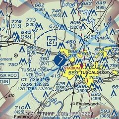
| Sectional chart |
|---|
|
 Download PDF
of official airport diagram from the FAA
| Airport distance calculator |
|---|
|
|
| Sunrise and sunset |
|---|
|
Times for 29-May-2026
| | Local
(UTC-5) | | Zulu
(UTC) |
|---|
| Morning civil twilight | | 05:16 | | 10:16 |
| Sunrise | | 05:44 | | 10:44 |
| Sunset | | 19:52 | | 00:52 |
| Evening civil twilight | | 20:20 | | 01:20 |
|
| Current date and time |
|---|
| Zulu (UTC) | 29-May-2026 15:59:21 |
|---|
| Local (UTC-5) | 29-May-2026 10:59:21 |
|---|
|
| METAR |
|---|
| KTCL | 291553Z 20004KT 8SM OVC012 25/22 A2999 RMK AO2 SLP151 T02500222
|
|
| TAF |
|---|
| KTCL | 291145Z 2912/3012 17003KT P6SM BKN010 FM291800 17006KT P6SM BKN035 TEMPO 2918/2922 18010G20KT 2SM TSRA BR BKN025CB OVC040 FM300000 14003KT P6SM BKN120 FM300800 00000KT P6SM BKN015
|
|
| NOTAMs |
|---|
NOTAMs are issued by the DoD/FAA and will open in a separate window not controlled by AirNav.
|
|


