FAA INFORMATION EFFECTIVE 16 APRIL 2026
Location
| FAA Identifier: | 0A8 |
| Lat/Long: | 32-56-12.9800N 087-05-25.9700W
32-56.216333N 087-05.432833W
32.9369389,-87.0905472
(estimated) |
| Elevation: | 250.9 ft. / 76.5 m (surveyed) |
| Variation: | 02W (2010) |
| From city: | 3 miles E of CENTREVILLE, AL |
| Time zone: | UTC -5 (UTC -6 during Standard Time) |
| Zip code: | 35042 |
Airport Operations
| Airport use: | Open to the public |
| Activation date: | 07/1962 |
| Control tower: | no |
| ARTCC: | ATLANTA CENTER |
| FSS: | ANNISTON FLIGHT SERVICE STATION |
| NOTAMs facility: | ANB (NOTAM-D service available) |
| Attendance: | UNATNDD
ARPT UNATNDD. |
| Wind indicator: | lighted |
| Segmented circle: | no |
| Lights: | ACTVT REIL RWY 10 & 28; PAPI RWY 10 & 28; MIRL RWY 10/28 - CTAF. |
| Beacon: | white-green (lighted land airport)
Operates sunset to sunrise. |
Airport Communications
- APCH/DEP SVC PRVDD BY ATLANTA ARTCC ON FREQS 132.25/263.025 (UNIONTOWN RCAG).
Nearby radio navigation aids
| VOR radial/distance | | VOR name | | Freq | | Var |
|---|
| OKWr156/19.8 | | BROOKWOOD VORTAC | | 111.00 | | 00E |
Airport Services
| Airframe service: | NONE |
| Powerplant service: | MINOR |
| Bottled oxygen: | NONE |
| Bulk oxygen: | NONE |
Runway Information
Runway 10/28
| Dimensions: | 4206 x 80 ft. / 1282 x 24 m |
| Surface: | asphalt/aggregate friction seal coat, in good condition |
| Weight bearing capacity: | |
| Runway edge lights: | medium intensity |
| RUNWAY 10 | | RUNWAY 28 |
| Latitude: | 32-56.246500N | | 32-56.186167N |
| Longitude: | 087-05.842500W | | 087-05.023167W |
| Elevation: | 238.5 ft. | | 250.9 ft. |
| Traffic pattern: | left | | left |
| Runway heading: | 097 magnetic, 095 true | | 277 magnetic, 275 true |
| Markings: | nonprecision, in fair condition | | nonprecision, in fair condition |
| Visual slope indicator: | 2-light PAPI on left (4.00 degrees glide path) | | 2-light PAPI on left (4.00 degrees glide path) |
| Runway end identifier lights: | yes | | yes |
| Touchdown point: | yes, no lights | | yes, no lights |
| Obstructions: | 17 ft. trees, 340 ft. from runway, 69 ft. left of centerline, 8:1 slope to clear | | 86 ft. trees, 615 ft. from runway, 165 ft. left of centerline, 4:1 slope to clear |
Airport Ownership and Management from official FAA records
| Ownership: | Publicly-owned |
| Owner: | BIBB COUNTY COMMISSION
157 SW DAVIDSON DRIVE
CENTREVILLE, AL 35042
Phone (205) 926-3114 |
| Manager: | SHANE WALLACE
P.O BOX 308
CENTREVILLE, AL 35042
Phone 205-247-6001
FOR ARPT ACES CTC 205-225-4763 OR 205-316-8574. |
Additional Remarks
| - | PILOT ACES VIA WALK THRU GATE ON NORTH SIDE OF ARPT. |
| - | FOR CD CTC ATLANTA ARTCC AT 770-210-7692. |
Instrument Procedures
NOTE: All procedures below are presented as PDF files. If you need a reader for these files, you should download the free Adobe Reader.NOT FOR NAVIGATION. Please procure official charts for flight.
FAA instrument procedures published for use from 16 April 2026 at 0901Z to 14 May 2026 at 0900Z.
IAPs - Instrument Approach Procedures |
|---|
| RNAV (GPS) RWY 10 | |
download (200KB) |
| RNAV (GPS) RWY 28 | |
download (210KB) |
| NOTE: Special Take-Off Minimums/Departure Procedures apply | |
download (189KB) |
Other nearby airports with instrument procedures:
KEET - Shelby County Airport (21 nm NE)
KEKY - Bessemer National Airport (24 nm N)
02A - Chilton County Airport (25 nm E)
A08 - Vaiden Field Airport (30 nm SW)
KTCL - Tuscaloosa National Airport (31 nm NW)
|
|

Road maps at:
MapQuest
Bing
Google
| Aerial photo |
|---|
WARNING: Photo may not be current or correct

Do you have a better or more recent aerial photo of Bibb County Airport that you would like to share? If so, please send us your photo.
|
| Sectional chart |
|---|
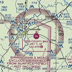
|
| Airport distance calculator |
|---|
|
|
| Sunrise and sunset |
|---|
|
Times for 24-Apr-2026
| | Local
(UTC-5) | | Zulu
(UTC) |
|---|
| Morning civil twilight | | 05:43 | | 10:43 |
| Sunrise | | 06:09 | | 11:09 |
| Sunset | | 19:24 | | 00:24 |
| Evening civil twilight | | 19:50 | | 00:50 |
|
| Current date and time |
|---|
| Zulu (UTC) | 24-Apr-2026 09:23:28 |
|---|
| Local (UTC-5) | 24-Apr-2026 04:23:28 |
|---|
|
| METAR |
|---|
KEET
21nm NE | 240853Z AUTO 00000KT 10SM CLR 13/12 A2993 RMK AO2 SLP130 T01330122 58010
|
KEKY
24nm N | 240856Z AUTO 18003KT 10SM CLR 16/12 A2994 RMK AO2 SLP113 T01610122 58010 $
|
KSEM
36nm S | 240855Z AUTO 00000KT 10SM FEW040 13/13 A2993 RMK AO2
|
KBHM
41nm NE | 240853Z 17004KT 10SM FEW250 18/13 A2994 RMK AO2 SLP133 T01830128 58011
|
K1A9
42nm SE | 240855Z AUTO 00000KT 10SM CLR 13/12 A2995 RMK AO2 T01300121
|
KSCD
42nm E | 240855Z AUTO 00000KT 10SM CLR 13/13 A2997 RMK AO2 T01330129 58004
|
|
| TAF |
|---|
KEET
21nm NE | 240520Z 2406/2506 00000KT P6SM FEW100 FM241400 20007KT P6SM SCT100 SCT250 FM242200 23007KT P6SM OVC100 PROB30 2502/2506 5SM SHRA BR OVC025
|
|
| NOTAMs |
|---|
NOTAMs are issued by the DoD/FAA and will open in a separate window not controlled by AirNav.
|
|

