FAA INFORMATION EFFECTIVE 14 MAY 2026
Location
| FAA Identifier: | TCM |
| Lat/Long: | 47-08-15.6400N 122-28-35.3100W
47-08.260667N 122-28.588500W
47.1376778,-122.4764750
(estimated) |
| Elevation: | 322 ft. / 98 m (estimated) |
| Variation: | 15E (2020) |
| From city: | 3 miles S of TACOMA, WA |
| Time zone: | UTC -7 (UTC -8 during Standard Time) |
| Zip code: | 98439 |
Airport Operations
| Airport use: | Private use. Permission required prior to landing |
| Activation date: | 08/1938 |
| Control tower: | yes |
| ARTCC: | SEATTLE CENTER |
| FSS: | SEATTLE FLIGHT SERVICE STATION |
| NOTAMs facility: | TCM (NOTAM-D service available) |
| Attendance: | CONTINUOUS |
| Segmented circle: | no |
| Lights: | SS-SR |
| Beacon: | white-green (lighted land airport)
Operates sunset to sunrise. |
| International operations: | international airport of entry
ONE HR NTC RQR FOR CSTMS. |
Airport Communications
| WX ASOS: | PHONE 253-982-3434 |
| MCCHORD GROUND: | 118.175 279.65 |
| MCCHORD TOWER: | 124.8 259.3 |
| SEATTLE APPROACH: | 126.5 |
| SEATTLE DEPARTURE: | 126.5 |
| ALCP: | 349.4 |
| COMD POST: | 134.1 |
| D-ATIS: | 135.825 270.1 |
| EMERG: | 121.5 243.0 |
| GLASR STAR: | 123.9 |
| JAWBN STAR: | 125.6 |
| PMSV METRO: | 342.3 ;UNUSBL 095-102 BYD 34 NM BLW |
| PTD: | 372.2 |
| WX AWOS-3 at PLU (8 nm E): | 128.575 (253-848-2748) |
| WX ASOS at TIW (9 nm NW): | PHONE 253-858-6507 |
| WX ASOS at SEA (20 nm N): | PHONE 206-214-2592 |
Nearby radio navigation aids
| VOR radial/distance | | VOR name | | Freq | | Var |
|---|
| SEAr182/19.1 | | SEATTLE VORTAC | | 116.80 | | 19E |
| OLMr041/20.0 | | OLYMPIA VORTAC | | 113.40 | | 19E |
Airport Services
| Airframe service: | MAJOR |
| Powerplant service: | MAJOR |
| Bottled oxygen: | NONE |
| Bulk oxygen: | HIGH/LOW |
Runway Information
Runway 16/34
| Dimensions: | 10108 x 150 ft. / 3081 x 46 m |
| Surface: | asphalt/concrete/grooved |
| Weight bearing capacity: | |
| Runway edge lights: | high intensity |
| RUNWAY 16 | | RUNWAY 34 |
| Latitude: | 47-09.092000N | | 47-07.429322N |
| Longitude: | 122-28.593833W | | 122-28.583178W |
| Elevation: | 281.7 ft. | | 321.4 ft. |
| Traffic pattern: | left | | right |
| Runway heading: | 165 magnetic, 180 true | | 345 magnetic, 360 true |
| Markings: | precision, in good condition | | precision, in good condition |
| Visual slope indicator: | 4-light PAPI on left (3.00 degrees glide path) | | 4-light PAPI on left (3.00 degrees glide path) |
| RVR equipment: | touchdown | | touchdown |
| Approach lights: | ALSF1: standard 2,400 foot high intensity approach lighting system with centerline sequenced flashers (category I) | | ALSF2: standard 2,400 foot high intensity approach lighting system with centerline sequenced flashers (category II or III) |
| Runway end identifier lights: | no | | no |
| Centerline lights: | yes | | yes |
| Touchdown point: | yes, no lights | | yes, lighted |
| Instrument approach: | LOC/GS | | ILS |
Runway 162/342
| Dimensions: | 3000 x 60 ft. / 914 x 18 m |
| Surface: | asphalt |
| RUNWAY 162 | | RUNWAY 342 |
| Traffic pattern: | left | | left |
Airport Ownership and Management from official FAA records
| Ownership: | U.S. Air Force |
| Owner: | USAF
62 AIR BASE GP, MCCHORD AFB
TACOMA, WA 98438 |
| Manager: | BASE OPERATIONS
62 AIR BASE GP, MCCHORD AFB
TACOMA, WA 98438
Phone 253-982-5611 |
Additional Remarks
| E60-34 | HOOK BAK-12B(B) (1668 FT). |
| E60-16 | HOOK BAK-12B(B) (2450 FT). |
| - | RSTD: AMC ACFT OPR RSTD DUR BIRD WATCH COND MODERATE (TKOF AND LDG PERMS ONLY WHEN DEP/ARR RTE AVOID IDENT BIRD ACT, NO LCL IFR/VFR TFC PAT ACT) AND SEVERE (TKOF AND LDG PROHWO OG/CC APVL), CTC PTD/ATIS/COMD POST FOR CURRENT BIRD WATCH COND. |
| - | RSTD: TRAN AIRCREWS CONDUCTING LCL AREA LO-LEVEL TRNG MSN MUST RCV LCL PRO/RSTD BRIEFING FR 62 OSS/OSK AT DSN 382-3615, C253-982-3615. |
| - | CAUTION: WHEN PERFORMING PRE-TKOF ENG RUNUP, ALIGN ACFT SO THAT DEBRIS IS NOT BLOWN TOWARD ADTAC ALERT HGR OR ADJ ACFT PRK RAMP. DUR VFR COND, ACFT MAKING LO APCH, NML TKOF, TOUCH AND GO LDG, OR MISSED APCH REMAIN AT OR BLW 1800 FT TIL DEP END OF THE RWY. |
| - | TFC PAT: BEFORE LDG MAINT TFC PAT ALT COMMENSURATE WITH SAFETY AS LONG AS PRACTICABLE. RECTANGULAR 1800', OVERHEAD 2300'. |
| - | CSTMS/AG/IMG: CSTMS AVBL, 1 HR PN RQR WKD 1600-0100Z++, OT 2 HR PN RQR. IMG ON CALL 24 HR PN DESIRED, 4 HR PN RQR. UNSKED ACFT ARR BTN 0900Z-1400Z++ MAY EXPERIENCE DELAYS FOR CSTMS/AG/IMG INSP. |
| - | ATIS PHONE NUMBER C 253-982-2847. DSN 382-2847. DIGITAL-ATIS, DATA LINK ENABLED. |
| - | FUEL: A++ |
| - | CAUTION: 1,000 FT RWY 16-34 IS CONCRETE; RWY IS GROOVED. RWY MRKD WITH WHITE NON-REFLECTIVE 90 FT X 3500 FT VFR DAY TIME ASSAULT LDG ZONE. |
| - | RWY COND CODES (RWYCC) UNAVBL |
| - | VOR OTS UFN |
| - | ALL TWY EDGE LGT AND RWY 16-34 EDGE, CNTRLN, TDZ LGT EQUIPPED WITH NTSD LED FIXTURES MAY NOT BE COMPATIBLE WITH ALL NVDS OR ENHANCED FLIGHT VISION SYSTEMS. |
| - | JASU: (MD-3M) 1(MD-3) 1(MA-1A) (AM32A-60) 1(MC-11). |
| - | FLUID: SP PRESAIR DE-ICE-EXP 3 HR DELAY. LHOX LOX. |
| - | OIL: O-128-133-148-156 SOAP - RESULTS RQR 24 HR, 1530-0030Z++ WKD EXC HOL, RESULTS NOT AVBL OT. TRAN ACFT REQ SOAP WILL ARR WITH HISTORICAL ENG SOAP DATA FOR TREND ANALYSIS. |
| - | TRAN ALERT: OPR H24. DELAYS CAN BE EXP. PRK LTD. ALL TRAN ACFT RQR TRAN ALERT FOLLOW ME ASSISTANCE. |
| - | AMP-1/AMP-3 OVERT/COVERT ASSAULT ZONE LGTS INSTL IN MIDDLE 5000 FT RY 16/34.SEE AP/1. |
| - | RSTD: ALL ACFT INC SKED AMC MSN RQR PPR 24 HR PRIOR TO ARR. PPR'S EFFECTIVE +/- 1 HR. TRAN ACFT PARK EXTREMELY LTD. MSN PLANNERS MUST CTC AMOPS WHEN USING MCCHORD AS DIVERT BASE. AMPOS DSN 382-5611, C253-982-5611. ACFT RON MORE THAN 3 DAYS AND/OR RQR OTHER THAN NORMAL TRANS SVC MUST CTC 62 AW/XP, 253-982-5890. ALL INBD ACFT MUST CTC COMD POST (RAINIER OPS) NO LATER THAN 30 MIN PRIOR TO LDG. |
Instrument Procedures
NOTE: All procedures below are presented as PDF files. If you need a reader for these files, you should download the free Adobe Reader.NOT FOR NAVIGATION. Please procure official charts for flight.
FAA instrument procedures published for use from 14 May 2026 at 0901Z to 11 June 2026 at 0900Z.
STARs - Standard Terminal Arrivals |
|---|
| ADYMS THREE (RNAV) | |
2 pages:
[1] [2] (375KB) |
| ARRIE NINE | |
download (147KB) |
| ARRIE NINE | |
download (147KB) |
| ELLENSBURG FOUR (RNAV) | |
download (239KB) |
| GLASR THREE | |
2 pages:
[1] [2] (369KB) |
| JAWBN SEVEN | |
download (197KB) |
| JAWBN SEVEN | |
download (197KB) |
| WHYTE SEVEN | |
download (187KB) |
IAPs - Instrument Approach Procedures |
|---|
| ILS OR LOC RWY 16 | |
download (163KB) |
| ILS OR LOC RWY 34 **CHANGED** | |
download (169KB) |
| ILS RWY 34 (CAT II) **CHANGED** | |
download (149KB) |
| RNAV (GPS) RWY 16 **CHANGED** | |
download (127KB) |
| RNAV (GPS) RWY 34 **CHANGED** | |
download (124KB) |
| TACAN RWY 16 **CHANGED** | |
download (141KB) |
| TACAN RWY 34 **CHANGED** | |
download (150KB) |
Departure Procedures |
|---|
| ALDER TWO | |
download (96KB) |
| MOCAA FOUR (RNAV) | |
download (245KB) |
| OLYMPIC FOUR | |
download (90KB) |
| PUGET SIX | |
download (91KB) |
| NOTE: Special Take-Off Minimums/Departure Procedures apply | |
download (559KB) |
Other nearby airports with instrument procedures:
KGRF - Gray Army Airfield (Joint Base Lewis-McChord) (6 nm SW)
KPLU - Pierce County Airport/Thun Field (8 nm E)
KTIW - Tacoma Narrows Airport (9 nm NW)
S50 - Auburn Municipal Airport (15 nm NE)
KSEA - Seattle-Tacoma International Airport (20 nm N)
|
|

Road maps at:
MapQuest
Bing
Google
| Aerial photo |
|---|
WARNING: Photo may not be current or correct
 Photo by Bryan J. Painter
Photo taken 15-Jun-2008
from 3,000 ft
Photo by Bryan J. Painter
Photo taken 15-Jun-2008
from 3,000 ft
Do you have a better or more recent aerial photo of McChord Field Airport (Joint Base Lewis-McChord) that you would like to share? If so, please send us your photo.
|
| Sectional chart |
|---|
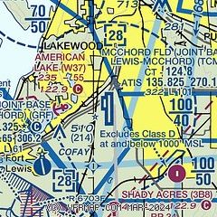
|
 Download PDF
of official airport diagram from the FAA
| Airport distance calculator |
|---|
|
|
| Sunrise and sunset |
|---|
|
Times for 29-May-2026
| | Local
(UTC-7) | | Zulu
(UTC) |
|---|
| Morning civil twilight | | 04:43 | | 11:43 |
| Sunrise | | 05:21 | | 12:21 |
| Sunset | | 20:54 | | 03:54 |
| Evening civil twilight | | 21:32 | | 04:32 |
|
| Current date and time |
|---|
| Zulu (UTC) | 29-May-2026 23:21:20 |
|---|
| Local (UTC-7) | 29-May-2026 16:21:20 |
|---|
|
| METAR |
|---|
| KTCM | 292255Z AUTO 26004KT 10SM FEW037 OVC049 18/05 A3005 RMK AO2 SLP179 T01800045 $
|
KGRF
6nm SW | 292255Z AUTO 25004KT 10SM OVC055 18/02 A3003 RMK AO2 SLP173 T01770024 $
|
KPLU
8nm E | 292255Z AUTO 00000KT 10SM OVC048 17/05 A3007 RMK AO2
|
KTIW
9nm NW | 292253Z 06005KT 10SM OVC065 14/08 A3006 RMK AO2 SLP179 T01440078
|
KSEA
20nm N | 292253Z 03003KT 10SM FEW020 BKN036 15/07 A3007 RMK AO2 SLP190 T01500072 $
|
|
| TAF |
|---|
| KTCM | 292100Z 2921/3103 24010KT 9999 BKN045 OVC080 QNH3003INS BECMG 3002/3003 20008KT 9999 BKN050 BKN100 QNH3010INS BECMG 3015/3016 20006KT 9999 BKN030 BKN200 QNH3026INS BECMG 3021/3022 34005KT 9999 SCT030 QNH3028INS TX17/2923Z TN07/3013Z
|
KGRF
6nm SW | 292100Z 2921/3103 21010G15KT 9999 BKN040 QNH2998INS BECMG 3001/3002 21010KT 9999 SCT060 QNH3002INS BECMG 3008/3009 18005KT 9999 BKN050 QNH3015INS BECMG 3011/3012 23003KT 9999 OVC065 QNH3017INS BECMG 3015/3016 21005KT 9999 BKN028 OVC060 QNH3024INS BECMG 3017/3018 26005KT 9999 OVC060 QNH3032INS TX18/2923Z TN07/3012Z
|
KSEA
20nm N | 292050Z 2921/3024 15009KT 3SM BR VCSH FEW007 OVC023 FM292200 03010KT P6SM BKN030 FM300300 03008KT P6SM BKN050 FM301100 VRB05KT P6SM BKN030
|
|
| NOTAMs |
|---|
NOTAMs are issued by the DoD/FAA and will open in a separate window not controlled by AirNav.
|
|


