FAA INFORMATION EFFECTIVE 14 MAY 2026
Location
| FAA Identifier: | TIW |
| Lat/Long: | 47-16-04.6000N 122-34-41.2000W
47-16.076667N 122-34.686667W
47.2679444,-122.5781111
(estimated) |
| Elevation: | 294.8 ft. / 89.9 m (surveyed) |
| Variation: | 20E (1990) |
| From city: | 4 miles W of TACOMA, WA |
| Time zone: | UTC -7 (UTC -8 during Standard Time) |
| Zip code: | 98335 |
Airport Operations
| Airport use: | Open to the public |
| Control tower: | yes |
| ARTCC: | SEATTLE CENTER |
| FSS: | SEATTLE FLIGHT SERVICE STATION |
| NOTAMs facility: | TIW (NOTAM-D service available) |
| Attendance: | 0700-1600 |
| Pattern altitude: | 1294.8 ft. MSL |
| Wind indicator: | lighted |
| Segmented circle: | yes |
| Lights: | WHEN ATCT CLSD, ACTVT MALSR RWY 17; REIL RWY 35; PAPI RWY 17 & 35; MIRL 17/35 - CTAF. |
| Beacon: | white-green (lighted land airport)
Operates sunset to sunrise. |
| International operations: | customs landing rights airport
CUSTOMS - 253-593-6338 EXT #2. |
Airport Communications
| CTAF: | 118.5 |
| UNICOM: | 122.95 |
| ATIS: | 124.05 |
| WX ASOS: | PHONE 253-858-6507 |
| TACOMA GROUND: | 121.8 [0800-2000] |
| TACOMA TOWER: | 118.5 253.5 [0800-2000] |
| SEATTLE APPROACH: | 120.1 |
| SEATTLE DEPARTURE: | 120.1 |
| WX ASOS at TCM (9 nm SE): | PHONE 253-982-3434 |
| WX AWOS-3PT at PWT (15 nm NW): | 121.2 (360-674-2811) |
| WX ASOS at SEA (15 nm NE): | PHONE 206-214-2592 |
| WX AWOS-3 at PLU (15 nm SE): | 128.575 (253-848-2748) |
| WX ASOS at BFI (19 nm NE): | PHONE 206-658-6435 |
| WX ASOS at RNT (20 nm NE): | 126.95 (425-255-6080) |
Nearby radio navigation aids
| VOR radial/distance | | VOR name | | Freq | | Var |
|---|
| SEAr208/14.8 | | SEATTLE VORTAC | | 116.80 | | 19E |
| OLMr018/22.2 | | OLYMPIA VORTAC | | 113.40 | | 19E |
Airport Services
| Fuel available: | 100LL JET-A |
| Parking: | hangars and tiedowns |
| Airframe service: | MAJOR |
| Powerplant service: | MAJOR |
| Bottled oxygen: | LOW |
Runway Information
Runway 17/35
| Dimensions: | 5002 x 100 ft. / 1525 x 30 m |
| Surface: | asphalt/grooved, in good condition |
| Weight bearing capacity: | | Single wheel: | 50.0 | | Double wheel: | 80.0 | | Double tandem: | 80.0 | | Dual double tandem: | 150.0 |
|
| Runway edge lights: | medium intensity |
| RUNWAY 17 | | RUNWAY 35 |
| Latitude: | 47-16.484690N | | 47-15.668117N |
| Longitude: | 122-34.612695W | | 122-34.760128W |
| Elevation: | 291.8 ft. | | 294.7 ft. |
| Traffic pattern: | left | | right |
| Runway heading: | 167 magnetic, 187 true | | 347 magnetic, 007 true |
| Markings: | precision, in good condition | | nonprecision, in good condition |
| Visual slope indicator: | 4-light PAPI on right (3.00 degrees glide path) | | 4-light PAPI on left (3.00 degrees glide path)
PAPI UNUSBL BYD 5.0 DEGREES LEFT OF CNTRLN. |
| Approach lights: | MALSR: 1,400 foot medium intensity approach lighting system with runway alignment indicator lights | | |
| Runway end identifier lights: | no | | yes |
| Touchdown point: | yes, no lights | | yes, no lights |
| Instrument approach: | ILS | | |
Airport Ownership and Management from official FAA records
| Ownership: | Publicly-owned |
| Owner: | PIERCE COUNTY PUB WORKS & UTILITIES
9850 - 64TH ST. W.
UNIVERSITY PLACE, WA 98467-7322
Phone 253-798-2421 |
| Manager: | ROD PROPST
1202 - 26TH AVE. N.W.
GIG HARBOR, WA 98335-7322
Phone 253-798-8550 |
Additional Remarks
| - | NOISE ABATEMENT PROC IN EFCT - AMGR. |
| - | DEER ON & INVOF ARPT. |
| - | LAWRS OPS DURG TWR HR. |
| - | EMERG FREQ 121.5 NOT MNT AT ATCT. |
| - | FOR CD WHEN ATCT IS CLSD CTC SEATTLE APCH AT 206-214-4723. |
Instrument Procedures
NOTE: All procedures below are presented as PDF files. If you need a reader for these files, you should download the free Adobe Reader.NOT FOR NAVIGATION. Please procure official charts for flight.
FAA instrument procedures published for use from 14 May 2026 at 0901Z to 11 June 2026 at 0900Z.
IAPs - Instrument Approach Procedures |
|---|
| ILS OR LOC RWY 17 | |
download (235KB) |
| RNAV (GPS) RWY 17 | |
download (251KB) |
| RNAV (GPS) RWY 35 | |
download (250KB) |
| NOTE: Special Alternate Minimums apply | |
download (86KB) |
Departure Procedures |
|---|
| NARROWS ONE | |
download (154KB) |
| NOTE: Special Take-Off Minimums/Departure Procedures apply | |
download (223KB) |
Other nearby airports with instrument procedures:
KTCM - McChord Field Airport (Joint Base Lewis-McChord) (9 nm SE)
KGRF - Gray Army Airfield (Joint Base Lewis-McChord) (11 nm S)
S50 - Auburn Municipal Airport (15 nm E)
KPWT - Bremerton National Airport (15 nm NW)
KSEA - Seattle-Tacoma International Airport (15 nm NE)
KPLU - Pierce County Airport/Thun Field (15 nm SE)
KBFI - Boeing Field/King County International Airport (19 nm NE)
KRNT - Renton Municipal Airport (20 nm NE)
|
|

Road maps at:
MapQuest
Bing
Google
| Aerial photo |
|---|
WARNING: Photo may not be current or correct
 Photo by Brian Quarles
Photo taken 06-Oct-2014
looking east/southeast.
Photo by Brian Quarles
Photo taken 06-Oct-2014
looking east/southeast.
Do you have a better or more recent aerial photo of Tacoma Narrows Airport that you would like to share? If so, please send us your photo.
|
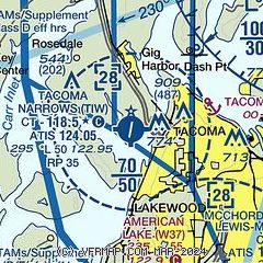
| Sectional chart |
|---|
|
CAUTION: Diagram may not be current
 Download PDF
of official airport diagram from the FAA
| Airport distance calculator |
|---|
|
|
| Sunrise and sunset |
|---|
|
Times for 08-Jun-2026
| | Local
(UTC-7) | | Zulu
(UTC) |
|---|
| Morning civil twilight | | 04:36 | | 11:36 |
| Sunrise | | 05:16 | | 12:16 |
| Sunset | | 21:03 | | 04:03 |
| Evening civil twilight | | 21:43 | | 04:43 |
|
| Current date and time |
|---|
| Zulu (UTC) | 08-Jun-2026 22:32:00 |
|---|
| Local (UTC-7) | 08-Jun-2026 15:32:00 |
|---|
|
| METAR |
|---|
| KTIW | 082153Z 05005KT 6SM -RA BR BKN055 OVC075 12/11 A2963 RMK AO2 SLP034 P0005 T01220106
|
KTCM
10nm SE | 082206Z 05005KT 8SM -RA SCT004 OVC050 14/12 A2962 RMK A02A TWR VIS 2 SLP034 $
|
KGRF
12nm S | 082205Z 01007KT 3SM RA BR OVC049 14/12 A2959 RMK AO2A SLP024 $
|
KSEA
15nm NE | 082153Z 35005KT 9SM -RA BKN065 OVC075 14/10 A2965 RMK AO2 SLP045 P0002 T01390100
|
KPLU
15nm SE | 082215Z AUTO 00000KT 4SM -DZ BKN050 13/13 A2963 RMK AO2
|
KPWT
16nm NW | 082156Z AUTO 36003KT 10SM -RA CLR 13/12 A2964 RMK AO2 SLP043 P0001 T01280117
|
KBFI
20nm NE | 082153Z 32004KT 10SM -RA OVC070 14/10 A2964 RMK AO2 RAB00 SLP038 P0000 T01440100
|
|
| TAF |
|---|
KTCM
10nm SE | 082100Z 0821/1003 03005KT 9000 -RA OVC060 620809 QNH2951INS BECMG 0905/0906 18010G15KT 9000 -RA BKN015 OVC030 620804 QNH2952INS BECMG 0907/0908 21015G25KT 9999 VCSH BKN015 OVC030 610804 510005 QNH2954INS BECMG 0916/0917 24015G30KT 8000 -SHRA BKN020 OVC040 610804 520005 QNH2986INS BECMG 0923/0924 24015G25KT 9999 VCSH BKN020 OVC040 610809 QNH3000INS TX16/0821Z TN11/0913Z
|
KGRF
12nm S | 082113Z 0821/1003 06005KT 8000 -RA FEW050 OVC070 650707 520309 QNH2959INS BECMG 0822/0823 06005KT 8000 -RA SCT010 BKN050 OVC060 650707 540309 QNH2963INS BECMG 0900/0901 08005KT 6000 -RA BKN015 OVC040 650806 540309 QNH2954INS BECMG 0903/0904 15005KT 8000 -RA BKN010 OVC020 650853 540309 QNH2952INS BECMG 0912/0913 18010G15KT 9999 NSW SCT010 BKN030 BKN095 620703 540109 QNH2975INS BECMG 0914/0915 17010G15KT 9999 SCT012 BKN015 BKN080 540159 QNH2983INS BECMG 0916/0917 17015G20KT 9999 SCT020 BKN030 BKN0
|
KSEA
15nm NE | 082214Z 0822/0924 03005KT P6SM -RA SCT035 BKN050 OVC070 FM082300 05007KT 5SM -RA BR OVC040 FM090300 12010KT 5SM -RA BR OVC022 FM090700 19012KT 6SM -RA BR OVC012 FM091200 21015G25KT 5SM -SHRA BR OVC015 FM092000 22014G22KT P6SM VCSH BKN025 OVC050
|
KPWT
16nm NW | 081720Z 0818/0918 VRB03KT P6SM VCSH BKN070 OVC120 FM082100 VRB05KT 6SM -RA BR OVC030 FM082300 05005KT 4SM -RA BR OVC020 FM090200 11006KT 3SM -RA BR OVC010 FM090800 20012G20KT 5SM -RA BR OVC007 FM091300 21015G23KT 6SM -SHRA BR OVC015
|
KBFI
20nm NE | 081720Z 0818/0918 VRB05KT P6SM VCSH SCT050 OVC070 FM082100 28006KT P6SM -RA SCT040 BKN050 OVC070 FM082300 04005KT 6SM -RA BR BKN040 OVC050 FM090300 14009KT 5SM -RA BR OVC025 FM090700 17010KT 5SM -RA BR OVC015 FM091200 20012G20KT 5SM -SHRA BR OVC018
|
|
| NOTAMs |
|---|
NOTAMs are issued by the DoD/FAA and will open in a separate window not controlled by AirNav.
|
|
FBO, Fuel Providers, and Aircraft Ground Support |
|---|
| | 
Business Name | |
Contact | |
Services / Description | |
Fuel Prices | |
Comments | |
|---|


|
|
UNICOM 122.95
253-851-5577
toll-free 800-645-3563
[web site]
[email] |
|
Serving you since 1982! Pavco has been servicing, fueling, chartering, training, maintaining, renting, and providing an aviation friendly environment to Tacoma Narrows Airport for over 35 years! We are your local Gig Harbor HERTZ RENTAL CAR AGENT with access to all categories of vehicles. 24-hour transient aircraft call-out service (1-800-645-3563), Volume JET-A discounts at 300, 500, & 1000 gallon increments and AVGAS at 50 gallons. We are an FAA repair station for piston engine, and your local Cessna Services Station.


|
|
|
|

write
|
|
|
|
|
UNICOM 122.95
253-853-7742
[web site]
[email] |
|
Skyport Aviation delivers elite ground handling with seamless efficiency, and executive-level care--while strategically managing fuel costs to pass meaningful savings directly on to customers.


|
|
 | | 100LL | Jet A | | FS | | $7.25 | | $7.60 | | SS | | $6.90 | | --- | | Updated 02-Jun-2026 |
|
|
write
|
|

|
| |
Aviation Businesses, Services, and Facilities |
|---|
| |
Business Name | |
Contact | |
Services / Description | |
Distance | |
Comments | |
|---|
|
|
|
253-313-0935
[web site]
[email] |
|
Northwest Aviation Medicine provides all classes of Aviation Medical Exams (1rst, 2nd,3rd, and Basic Med) as well as EKGs and aviation consultation (in person or via virtual/telehealth platform) for more complicated certification issues.
|
|
on airport |
|
write
|
|
|
|
|
253-851-3009
toll-free 800-821-9927
[web site]
[email] |
|
Avionics sales and service, Aviation accessories
|
|
on airport |
|
write
|
|
| |
Where to Eat: Catering, Restaurants, Food shops |
|---|
| |
Business Name | |
Contact | |
Services / Description | |
Distance | |
Comments | |
|---|
| The Hub at Gig Harbor Restaurant |
|
253-853-1585
253-224-2624
[web site]
[email]

|
|
Catering, Internet access, Restrooms, Restaurant
|
|
on airport |
|
write
|
|
| |
Would you like to see your business listed on this page? |
|---|
| | If your business provides an interesting product or service to pilots, flight crews, aircraft, or users of the Tacoma Narrows Airport, you should consider listing it here. To start the listing process, click on the button below

|


