FAA INFORMATION EFFECTIVE 11 JUNE 2026
Location
| FAA Identifier: | TKX |
| Lat/Long: | 36-13-33.1030N 090-02-11.9080W
36-13.551717N 090-02.198467W
36.2258619,-90.0366411
(estimated) |
| Elevation: | 261.8 ft. / 79.8 m (surveyed) |
| Variation: | 00E (2000) |
| From city: | 1 mile SE of KENNETT, MO |
| Time zone: | UTC -5 (UTC -6 during Standard Time) |
| Zip code: | 63857 |
Airport Operations
| Airport use: | Open to the public |
| Activation date: | 04/1940 |
| Control tower: | no |
| ARTCC: | MEMPHIS CENTER |
| FSS: | SAINT LOUIS FLIGHT SERVICE STATION |
| NOTAMs facility: | STL (NOTAM-D service available) |
| Attendance: | MON-SAT 0800-1700, ALL SUN 1300-1700 |
| Wind indicator: | lighted |
| Segmented circle: | yes |
| Lights: | MIRL RYS 18/36 & 02/20 ON LOW INTST DUSK-0300; TO INCR INTST & ACTVT MIRL RYS 18/36 & 02/20 & REIL RYS 02; 20 FM 2300-DAWN - CTAF. PAPI RYS 02 & 20 ON 24 HRS. |
| Beacon: | white-green (lighted land airport)
Operates sunset to sunrise. |
Airport Communications
| CTAF/UNICOM: | 122.8 |
| WX AWOS-3PT: | 119.05 (573-888-9640) |
| WX ASOS at HKA (20 nm SE): | 135.025 (870-763-8206) |
- APCH/DEP SVC PRVDD BY MEMPHIS ARTCC FREQS 120.075/289.4 (WALNUT RIDGE RCAG).
Nearby radio navigation aids
| VOR radial/distance | | VOR name | | Freq | | Var |
|---|
| JBRr052/34.1 | | JONESBORO VOR/DME | | 115.85 | | 00W |
Airport Services
| Fuel available: | 100LL JET-A |
| Parking: | tiedowns |
| Airframe service: | MAJOR |
| Powerplant service: | MAJOR |
| Bottled oxygen: | NONE |
| Bulk oxygen: | NONE |
Runway Information
Runway 2/20
| Dimensions: | 5000 x 75 ft. / 1524 x 23 m |
| Surface: | concrete, in good condition |
| Weight bearing capacity: | | Single wheel: | 30.0 | | Double wheel: | 42.0 |
|
| Runway edge lights: | medium intensity |
| RUNWAY 2 | | RUNWAY 20 |
| Latitude: | 36-13.032778N | | 36-13.817115N |
| Longitude: | 090-02.434002W | | 090-02.121920W |
| Elevation: | 258.5 ft. | | 258.3 ft. |
| Traffic pattern: | right | | left |
| Runway heading: | 018 | | 198 |
| Markings: | nonprecision, in good condition | | nonprecision, in good condition |
| Visual slope indicator: | 4-light PAPI on left (3.00 degrees glide path) | | 4-light PAPI on left (3.00 degrees glide path) |
| Runway end identifier lights: | yes | | yes |
| Touchdown point: | yes, no lights | | yes, no lights |
| Obstructions: | 43 ft. tree, 1065 ft. from runway, 300 ft. left of centerline, 20:1 slope to clear | | 45 ft. tree, 1560 ft. from runway, 390 ft. left of centerline, 30:1 slope to clear |
Runway 18/36
| Dimensions: | 3012 x 75 ft. / 918 x 23 m |
| Surface: | asphalt, in good condition |
| Weight bearing capacity: | |
| Runway edge lights: | medium intensity |
| RUNWAY 18 | | RUNWAY 36 |
| Latitude: | 36-14.010335N | | 36-13.514212N |
| Longitude: | 090-02.074460W | | 090-02.058707W |
| Elevation: | 260.1 ft. | | 257.8 ft. |
| Traffic pattern: | left | | right |
| Runway heading: | 179 | | 359 |
| Markings: | basic, in good condition | | basic, in good condition |
| Touchdown point: | yes, no lights | | yes, no lights |
| Obstructions: | none | | 33 ft. trees, 543 ft. from runway, 140 ft. right of centerline, 10:1 slope to clear |
Airport Ownership and Management from official FAA records
| Ownership: | Publicly-owned |
| Owner: | CITY OF KENNETT
200 CEDAR ST.
KENNETT, MO 63857
Phone 573-888-9001 |
| Manager: | SAMMY JEWELL
PO BOX 623
KENNETT, MO 63857
Phone 573-888-5846 |
Additional Remarks
| - | AIRPORT PHONE (573) 888-1339. |
| - | FOR CD CTC MEMPHIS ARTCC AT 901-368-8453/8449. |
Instrument Procedures
NOTE: All procedures below are presented as PDF files. If you need a reader for these files, you should download the free Adobe Reader.NOT FOR NAVIGATION. Please procure official charts for flight.
FAA instrument procedures published for use from 11 June 2026 at 0901Z to 09 July 2026 at 0900z.
IAPs - Instrument Approach Procedures |
|---|
| RNAV (GPS) RWY 02 | |
download (236KB) |
| RNAV (GPS) RWY 20 | |
download (242KB) |
| NOTE: Special Take-Off Minimums/Departure Procedures apply | |
download (421KB) |
Other nearby airports with instrument procedures:
M12 - Steele Municipal Airport (12 nm SE)
M85 - Gideon Memorial Airport (15 nm NE)
KBYH - Arkansas International Airport (16 nm S)
M05 - Caruthersville Memorial Airport (18 nm E)
KHKA - Blytheville Municipal Airport (20 nm SE)
|
|

Road maps at:
MapQuest
Bing
Google
| Aerial photo |
|---|
WARNING: Photo may not be current or correct
 Photo by Duane Deniston; Pilot David Hanners.
Photo taken 21-Sep-2013
looking south.
Photo by Duane Deniston; Pilot David Hanners.
Photo taken 21-Sep-2013
looking south.
Do you have a better or more recent aerial photo of Kennett Memorial Airport that you would like to share? If so, please send us your photo.
|
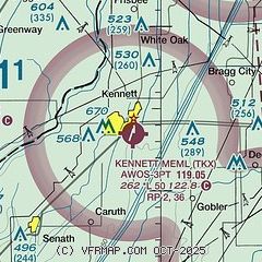
| Sectional chart |
|---|
|
| Airport distance calculator |
|---|
|
|
| Sunrise and sunset |
|---|
|
Times for 11-Jun-2026
| | Local
(UTC-5) | | Zulu
(UTC) |
|---|
| Morning civil twilight | | 05:13 | | 10:13 |
| Sunrise | | 05:43 | | 10:43 |
| Sunset | | 20:16 | | 01:16 |
| Evening civil twilight | | 20:47 | | 01:47 |
|
| Current date and time |
|---|
| Zulu (UTC) | 11-Jun-2026 20:01:59 |
|---|
| Local (UTC-5) | 11-Jun-2026 15:01:59 |
|---|
|
| METAR |
|---|
| KTKX | 111955Z AUTO 21016G24KT 10SM SCT055 36/22 A2985 RMK AO2
|
|
| TAF |
|---|
KJBR
38nm SW | 111720Z 1118/1218 21014G25KT P6SM SCT040 FM120100 22009KT P6SM SCT250 FM120800 30006KT 6SM -SHRA SCT040 OVC060 FM121200 34009KT P6SM BKN060
|
|
| NOTAMs |
|---|
NOTAMs are issued by the DoD/FAA and will open in a separate window not controlled by AirNav.
|
|

