FAA INFORMATION EFFECTIVE 14 MAY 2026
Location
| FAA Identifier: | M85 |
| Lat/Long: | 36-26-37.5210N 089-54-13.8180W
36-26.625350N 089-54.230300W
36.4437558,-89.9038383
(estimated) |
| Elevation: | 269 ft. / 82 m (estimated) |
| Variation: | 02W (2015) |
| From city: | 1 mile SE of GIDEON, MO |
| Time zone: | UTC -5 (UTC -6 during Standard Time) |
| Zip code: | 63848 |
Airport Operations
| Airport use: | Open to the public |
| Activation date: | 01/1944 |
| Control tower: | no |
| ARTCC: | MEMPHIS CENTER |
| FSS: | SAINT LOUIS FLIGHT SERVICE STATION |
| NOTAMs facility: | STL (NOTAM-D service available) |
| Attendance: | IREG |
| Wind indicator: | yes |
| Segmented circle: | yes |
Airport Communications
| CTAF: | 122.9 |
| WX AWOS-3PT at MAW (10 nm NW): | 119.825 (573-276-9970) |
| WX AWOS-3PT at TKX (15 nm SW): | 119.05 (573-888-9640) |
- APCH/DEP SVC PRVDD BY MEMPHIS ARTCC ON FREQS 133.65/292.15 (PADUCAH RCAG).
Airport Services
Runway Information
Runway 15/33
| Dimensions: | 4504 x 58 ft. / 1373 x 18 m
WIDTH VARIES FM 58-60 FT. |
| Surface: | asphalt, in good condition |
| Runway edge markings: | RWY MARKINGS SEVERLY FADED |
| RUNWAY 15 | | RUNWAY 33 |
| Latitude: | 36-26.946200N | | 36-26.303483N |
| Longitude: | 089-54.459483W | | 089-54.000067W |
| Elevation: | 267.0 ft. | | 269.0 ft. |
| Traffic pattern: | left | | left |
| Runway heading: | 152 magnetic, 150 true | | 332 magnetic, 330 true |
| Markings: | nonprecision, in poor condition | | nonprecision, in poor condition |
| Touchdown point: | yes, no lights | | yes, no lights |
| Obstructions: | 43 ft. tree, 750 ft. from runway, 300 ft. right of centerline, 12:1 slope to clear | | 13 ft. road, 330 ft. from runway, 250 ft. left and right of centerline, 10:1 slope to clear |
Airport Ownership and Management from official FAA records
| Ownership: | Publicly-owned |
| Owner: | CITY OF GIDEON
109 MAIN ST, PO BOX 396
GIDEON, MO 63848
Phone 573-448-3500 |
| Manager: | JOSHUA ATCHLEY
109 MAIN ST., PO BOX 396
GIDEON, MO 63848
Phone 573-225-5225 |
Additional Remarks
| - | N TWY TO RY 15 THLD CLSD; S TWY N OF RY 33 THLD CLSD. |
| - | CROP DUSTING & ULTRALIGHT ACFT ON & INVOF ARPT. |
| - | RY N/S CLSD; USED FOR FLYING OF MODEL PLANES. |
| - | ARPT CLSD DAILY SS-SR, EXCP HELICOPTER OPNS. |
| - | GRASS GROWING IN CRACKS ON PARL TWY. |
| - | FOR CD CTC MEMPHIS ARTCC AT 901-368-8453/8449. |
Instrument Procedures
NOTE: All procedures below are presented as PDF files. If you need a reader for these files, you should download the free Adobe Reader.NOT FOR NAVIGATION. Please procure official charts for flight.
FAA instrument procedures published for use from 14 May 2026 at 0901Z to 11 June 2026 at 0900Z.
IAPs - Instrument Approach Procedures |
|---|
| RNAV (GPS) RWY 15 | |
download (172KB) |
| RNAV (GPS) RWY 33 | |
download (182KB) |
| NOTE: Special Take-Off Minimums/Departure Procedures apply | |
download (425KB) |
Other nearby airports with instrument procedures:
KMAW - Malden Regional Airport (10 nm NW)
KTKX - Kennett Memorial Airport (15 nm SW)
KEIW - County Memorial Airport (16 nm E)
M05 - Caruthersville Memorial Airport (20 nm SE)
KDXE - Dexter Municipal Airport (20 nm N)
|
|

Road maps at:
MapQuest
Bing
Google
| Aerial photo |
|---|

|
| Sectional chart |
|---|
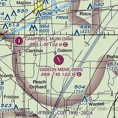
|
| Airport distance calculator |
|---|
|
|
| Sunrise and sunset |
|---|
|
Times for 04-Jun-2026
| | Local
(UTC-5) | | Zulu
(UTC) |
|---|
| Morning civil twilight | | 05:13 | | 10:13 |
| Sunrise | | 05:43 | | 10:43 |
| Sunset | | 20:13 | | 01:13 |
| Evening civil twilight | | 20:43 | | 01:43 |
|
| Current date and time |
|---|
| Zulu (UTC) | 04-Jun-2026 17:34:43 |
|---|
| Local (UTC-5) | 04-Jun-2026 12:34:43 |
|---|
|
| METAR |
|---|
KMAW
10nm NW | 041715Z AUTO 20009KT 10SM CLR 27/15 A3018 RMK AO1
|
KTKX
15nm SW | 041715Z AUTO 20009G15KT 10SM CLR 29/16 A3015 RMK AO2
|
|
| TAF |
|---|
KCGI
50nm N | 041120Z 0412/0512 18004KT P6SM SCT040 FM041700 19006KT P6SM SCT060 FM050100 17004KT P6SM SCT250
|
|
| NOTAMs |
|---|
NOTAMs are issued by the DoD/FAA and will open in a separate window not controlled by AirNav.
|
|

