FAA INFORMATION EFFECTIVE 16 APRIL 2026
Location
| FAA Identifier: | TVF |
| Lat/Long: | 48-03-56.4380N 096-11-05.9830W
48-03.940633N 096-11.099717W
48.0656772,-96.1849953
(estimated) |
| Elevation: | 1118.8 ft. / 341.0 m (surveyed) |
| Variation: | 02E (2015) |
| From city: | 3 miles S of THIEF RIVER FALLS, MN |
| Time zone: | UTC -5 (UTC -6 during Standard Time) |
| Zip code: | 56701 |
Airport Operations
| Airport use: | Open to the public |
| Activation date: | 07/1945 |
| Control tower: | no |
| ARTCC: | MINNEAPOLIS CENTER |
| FSS: | PRINCETON FLIGHT SERVICE STATION |
| NOTAMs facility: | TVF (NOTAM-D service available) |
| Attendance: | MON-FRI 0800-1700, ALL SAT-SUN ON CALL |
| Wind indicator: | lighted |
| Segmented circle: | no |
| Lights: | ACTVT MALSR RWY 31; REIL RWY 13, 04, & 22; HIRL RWY 13/31; MIRL RWY 04/22 - CTAF. PAPI RWY 13, 31, 04, & 22 OPR CONSLY. |
| Beacon: | white-green (lighted land airport)
Operates sunset to sunrise. |
| Fire and rescue: | ARFF index A |
| Airline operations: | 48 HR PPR FOR UNSKED ACR OPS GTR THAN 30 PAX SEATS CALL AMGR 218-681-7680. |
Airport Communications
| CTAF/UNICOM: | 122.8 |
| WX AWOS-3PT: | 119.025 (218-681-1918) |
- APCH/DEP SVC PRVDD BY MINNEAPOLIS ARTCC ON FREQS 132.15/269.6 (GRAND FORKS RCAG).
Nearby radio navigation aids
| VOR radial/distance | | VOR name | | Freq | | Var |
|---|
| TVF at field | | THIEF RIVER FALLS VOR/DME | | 114.45 | | 08E |
Airport Services
| Fuel available: | 100LL JET-A JET-A+
100LL:AVBL 24 HRS WITH CREDIT CARD. |
| Parking: | hangars and tiedowns |
| Airframe service: | MAJOR |
| Powerplant service: | MAJOR |
Runway Information
Runway 13/31
| Dimensions: | 6504 x 150 ft. / 1982 x 46 m |
| Surface: | asphalt/grooved, in good condition |
| Weight bearing capacity: | | Single wheel: | 83.0 | | Double wheel: | 106.0 | | Double tandem: | 163.0 |
|
| Runway edge lights: | high intensity |
| RUNWAY 13 | | RUNWAY 31 |
| Latitude: | 48-04.257158N | | 48-03.503755N |
| Longitude: | 096-11.602045W | | 096-10.469265W |
| Elevation: | 1114.8 ft. | | 1113.2 ft. |
| Traffic pattern: | left | | left |
| Runway heading: | 133 magnetic, 135 true | | 313 magnetic, 315 true |
| Declared distances: | TORA:6504 TODA:6504 ASDA:6504 LDA:6504 | | TORA:6504 TODA:6504 ASDA:6304 LDA:6304 |
| Markings: | precision, in good condition | | precision, in good condition |
| Visual slope indicator: | 4-light PAPI on left (3.00 degrees glide path) | | 4-light PAPI on left (3.00 degrees glide path) |
| Approach lights: | | | MALSR: 1,400 foot medium intensity approach lighting system with runway alignment indicator lights |
| Runway end identifier lights: | yes | | |
| Touchdown point: | yes, no lights | | yes, no lights |
| Instrument approach: | | | ILS |
Runway 4/22
| Dimensions: | 4997 x 75 ft. / 1523 x 23 m |
| Surface: | asphalt/grooved, in good condition |
| Weight bearing capacity: | | Single wheel: | 83.0 | | Double wheel: | 106.0 | | Double tandem: | 163.0 |
|
| Runway edge lights: | medium intensity |
| Operational restrictions: | RWY 04/22 NOT AVBL FOR PART 121/PART 380 OPS WITH SKED PAX CARRYING OPS MORE THAN 9 PAX SEATS AND NON-SKED PAX CARRYING OPS MORE THAN 30 PAX SEATS. |
| RUNWAY 4 | | RUNWAY 22 |
| Latitude: | 48-03.700545N | | 48-04.337297N |
| Longitude: | 096-11.570670W | | 096-10.795623W |
| Elevation: | 1112.5 ft. | | 1118.3 ft. |
| Traffic pattern: | left | | left |
| Runway heading: | 037 magnetic, 039 true | | 217 magnetic, 219 true |
| Declared distances: | TORA:4997 TODA:4997 ASDA:4997 LDA:4997 | | TORA:4997 TODA:4997 ASDA:4997 LDA:4997 |
| Markings: | nonprecision, in good condition | | nonprecision, in good condition |
| Visual slope indicator: | 4-light PAPI on left (3.00 degrees glide path) | | 4-light PAPI on left (3.00 degrees glide path) |
| Runway end identifier lights: | yes | | yes |
| Touchdown point: | yes, no lights | | yes, no lights |
Airport Ownership and Management from official FAA records
| Ownership: | Publicly-owned |
| Owner: | THIEF RIVER FALLS ARPT AUTH
13722 AIRPORT DR, PO BOX 672
THIEF RIVER FALLS, MN 56701-0672
Phone 218-681-7680 |
| Manager: | JOSEPH HEDRICK
THIEF RIVER FALLS ARPT AUTH, 13722 AIRPORT DR
THIEF RIVER FALLS, MN 56701-8497
Phone 218-684-1013 |
Additional Remarks
| A39-13/31 | PCR VALUE: 340/F/D/X/T |
| A39-04/22 | PCR VALUE: 390/F/D/X/T |
| - | BIRDS ON & INVOF ARPT. |
| - | ARPT CONDS NOT MNTD SUN-FRI 2200-0500; FRI 2200-SAT 0600; SAT 1030-1500; SAT 2000-SUN 0600. |
| - | FOR CD IF UNA TO CTC ON FSS FREQ, CTC MINNEAPOLIS ARTCC AT 651-463-5588. |
| - | LDG FEES FOR COML ACFT CALL AMGR 218-681-7680 OPTION 7. |
Instrument Procedures
NOTE: All procedures below are presented as PDF files. If you need a reader for these files, you should download the free Adobe Reader.NOT FOR NAVIGATION. Please procure official charts for flight.
FAA instrument procedures published for use from 16 April 2026 at 0901Z to 14 May 2026 at 0900Z.
IAPs - Instrument Approach Procedures |
|---|
| ILS OR LOC RWY 31 | |
download (208KB) |
| RNAV (GPS) RWY 04 | |
download (200KB) |
| RNAV (GPS) RWY 13 | |
download (252KB) |
| RNAV (GPS) RWY 22 | |
download (233KB) |
| RNAV (GPS) RWY 31 | |
download (240KB) |
| VOR RWY 31 | |
download (141KB) |
| VOR Y RWY 13 | |
download (144KB) |
| VOR Z RWY 13 | |
download (149KB) |
| NOTE: Special Alternate Minimums apply | |
download (187KB) |
| NOTE: Special Take-Off Minimums/Departure Procedures apply | |
download |
Other nearby airports with instrument procedures:
KCKN - Crookston Municipal Airport - Kirkwood Field (22 nm SW)
D37 - Warren Municipal Airport (22 nm W)
D14 - Fertile Municipal Airport (31 nm S)
KFSE - Fosston Municipal Airport/Anderson Field (33 nm SE)
KGFK - Grand Forks International Airport (40 nm W)
|
|

Road maps at:
MapQuest
Bing
Google
| Aerial photo |
|---|
WARNING: Photo may not be current or correct
 Photo taken 27-Sep-2008
Do you have a better or more recent aerial photo of Thief River Falls Regional Airport that you would like to share? If so, please send us your photo.
|
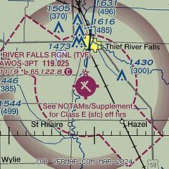
| Sectional chart |
|---|
|
| Airport distance calculator |
|---|
|
|
| Sunrise and sunset |
|---|
|
Times for 27-Apr-2026
| | Local
(UTC-5) | | Zulu
(UTC) |
|---|
| Morning civil twilight | | 05:40 | | 10:40 |
| Sunrise | | 06:14 | | 11:14 |
| Sunset | | 20:31 | | 01:31 |
| Evening civil twilight | | 21:05 | | 02:05 |
|
| Current date and time |
|---|
| Zulu (UTC) | 27-Apr-2026 07:22:54 |
|---|
| Local (UTC-5) | 27-Apr-2026 02:22:54 |
|---|
|
| METAR |
|---|
| KTVF | 270656Z AUTO 11012KT 8SM -RA OVC035 06/04 A2998 RMK AO2 RAB07 SLP160 T00560044
|
|
| TAF |
|---|
| KTVF | 270520Z 2706/2806 11009KT P6SM BKN120 FM270700 08013KT 6SM -RA OVC050 FM270800 05015KT 3SM -RA OVC013 FM271000 04015G24KT 3SM -RA BR OVC008 FM271700 01020G31KT 6SM -RA OVC011 FM280300 33016G24KT P6SM BKN050
|
|
| NOTAMs |
|---|
NOTAMs are issued by the DoD/FAA and will open in a separate window not controlled by AirNav.
|
|

