FAA INFORMATION EFFECTIVE 14 MAY 2026
Location
| FAA Identifier: | TYS |
| Lat/Long: | 35-48-39.9280N 083-59-38.6420W
35-48.665467N 083-59.644033W
35.8110911,-83.9940672
(estimated) |
| Elevation: | 986.4 ft. / 300.7 m (surveyed) |
| Variation: | 06W (2015) |
| From city: | 10 miles S of KNOXVILLE, TN |
| Time zone: | UTC -4 (UTC -5 during Standard Time) |
| Zip code: | 37701 |
Airport Operations
| Airport use: | Open to the public |
| Activation date: | 01/1970 |
| Control tower: | yes |
| ARTCC: | ATLANTA CENTER |
| FSS: | NASHVILLE FLIGHT SERVICE STATION |
| NOTAMs facility: | TYS (NOTAM-D service available) |
| Attendance: | CONTINUOUS |
| Wind indicator: | lighted |
| Segmented circle: | yes |
| Lights: | SS-SR |
| Beacon: | white-green (lighted land airport)
Operates sunset to sunrise. |
| Fire and rescue: | ARFF index C |
| International operations: | customs landing rights airport |
Airport Communications
| UNICOM: | 122.95 |
| ATIS: | 128.35 |
| WX ASOS: | PHONE 423-219-5043 |
| KNOXVILLE GROUND: | 121.9 348.6 |
| KNOXVILLE TOWER: | 121.2 257.8 |
| KNOXVILLE APPROACH: | 118.0 ;051-229 123.9 ;230-050 353.6 ;230-050 360.8 ;051-229 125.525 |
| KNOXVILLE DEPARTURE: | 118.0 ;051-229 123.9 ;230-050 353.6 ;230-050 360.8 ;051-229 125.525 |
| CLEARANCE DELIVERY: | 121.65 |
| ANG OPS: | 143.8 303.25 ;SODA CAN CON |
| ARNG OPS: | 149.8 373.9 49.95 |
| CLASS C: | 118.0 ;051-229 123.9 ;230-050 353.6 ;230-050 360.8 ;051-229 |
| EMERG: | 121.5 243.0 |
| IC: | 123.9 ;230-050 360.8 ;051-229 |
| WX AWOS-3 at DKX (11 nm NE): | 125.375 (865-579-6151) |
Nearby radio navigation aids
| VOR radial/distance | | VOR name | | Freq | | Var |
|---|
| VXVr224/7.4 | | VOLUNTEER VORTAC | | 116.40 | | 03W |
Airport Services
| Fuel available: | 100LL JET-A JET-A++
100LL:MIL CONTR FUEL AVBL. |
| Parking: | hangars and tiedowns |
| Airframe service: | MAJOR |
| Powerplant service: | MAJOR |
| Bulk oxygen: | HIGH |
Runway Information
Runway 5L/23R
| Dimensions: | 10000 x 150 ft. / 3048 x 46 m |
| Surface: | concrete/grooved, in good condition |
| Weight bearing capacity: | | Single wheel: | 120.0 | | Double wheel: | 250.0 | | Double tandem: | 550.0 | | Dual double tandem: | 1120.0 |
|
| Runway edge lights: | high intensity |
| RUNWAY 5L | | RUNWAY 23R |
| Latitude: | 35-48.202453N | | 35-49.371530N |
| Longitude: | 084-00.398042W | | 083-58.971698W |
| Elevation: | 925.9 ft. | | 986.4 ft. |
| Traffic pattern: | left | | right |
| Runway heading: | 051 magnetic, 045 true | | 231 magnetic, 225 true |
| Displaced threshold: | 490 ft. | | 505 ft. |
| Declared distances: | TORA:10000 TODA:10000 ASDA:10000 LDA:9508 | | TORA:10000 TODA:10000 ASDA:10000 LDA:9495 |
| Markings: | precision, in good condition | | precision, in good condition |
| Visual slope indicator: | 4-light PAPI on left (3.00 degrees glide path) | | 4-light PAPI on left (3.00 degrees glide path) |
| RVR equipment: | touchdown, midfield, rollout | | touchdown, midfield, rollout |
| Approach lights: | MALSR: 1,400 foot medium intensity approach lighting system with runway alignment indicator lights | | ALSF2: standard 2,400 foot high intensity approach lighting system with centerline sequenced flashers (category II or III) |
| Runway end identifier lights: | | | no |
| Centerline lights: | yes | | yes |
| Touchdown point: | yes, no lights | | yes, lighted |
| Instrument approach: | ILS | | ILS |
Runway 5R/23L
| Dimensions: | 9000 x 150 ft. / 2743 x 46 m |
| Surface: | asphalt/grooved, in poor condition |
| Weight bearing capacity: | | Single wheel: | 75.0 | | Double wheel: | 250.0 | | Double tandem: | 489.0 | | Dual double tandem: | 1106.0 |
|
| Runway edge lights: | high intensity |
| RUNWAY 5R | | RUNWAY 23L |
| Latitude: | 35-48.004215N | | 35-49.056535N |
| Longitude: | 084-00.240195W | | 083-58.956772W |
| Elevation: | 938.3 ft. | | 962.3 ft. |
| Traffic pattern: | right | | left |
| Runway heading: | 051 magnetic, 045 true | | 231 magnetic, 225 true |
| Displaced threshold: | no | | 397 ft. |
| Declared distances: | TORA:9000 TODA:9000 ASDA:8600 LDA:8600 | | TORA:9000 TODA:9000 ASDA:9000 LDA:8600 |
| Markings: | precision, in good condition | | precision, in good condition |
| Visual slope indicator: | 4-light PAPI on left (3.00 degrees glide path) | | 4-light PAPI on left (3.00 degrees glide path) |
| RVR equipment: | rollout | | touchdown |
| Runway end identifier lights: | yes | | yes |
| Centerline lights: | yes | | yes |
| Touchdown point: | yes, no lights | | yes, no lights |
| Instrument approach: | | | ILS/DME |
Airport Ownership and Management from official FAA records
| Ownership: | Publicly-owned |
| Owner: | METRO KNOXVILLE ARPT AUTH
MC GHEE TYSON AIRPORT, 2055 ALCOA HWY
ALCOA, TN 37701
Phone 865-342-3000 |
| Manager: | PATRICK WILSON
P.O. BOX 15600
KNOXVILLE, TN 37901
Phone 865-342-3088 |
Additional Remarks
| A39-05L/23R | PCR VALUE: 761/R/B/W/T |
| A39-05R/23L | PCR VALUE: 492/F/B/X/U |
| - | WIDE BODY USE CTN TURNING ONTO TWY A FM RAMP 4, 5 & 6. |
| - | CTN: PTN OF TWY A NEAR RWY 05R APCH END NOT VSB FM TWR. |
| - | ANG OPS CTC SODA CTL 303.025. |
| - | ANG: COMD POST H24 - D266-4371/ C865-336-4371. AMGR DOES NOT ISSUE OR STORE COMSEC FOR TSNT. TMPRY STOR OF CLASSIFIED MATERIALS UP TO TOP SECRET AT COMD POST. |
| - | ANG: PPR 24 HR PN RQR, LTD TO OFFL BUS ONLY, CTC AIRFIELD MGMT DSN 266-4404/4419, C865-336-4404/4419. OPR 0700-1630 MON-FRI (CLSD EV OTH MON), FAC CLSD SAT, SUN AND HOL. |
| - | CTN: HOLD SHORT LINE FOR RWY 23L SLIGHTLY N OF TWY A-8. |
| - | ANG: ARNG RAMP NOT SUITABLE FOR AMC ACFT EXC C-21. |
| - | CSTMS/AG/IMG: MIL CUSTOMS 72 HR PPR. |
| - | RWY 5L/23R & 5R/23L WT BRG CPTY FOR 2S LNDG GEAR IS 175. |
| - | ACFT DESIGN GROUP V OR LRGR USING TRML RAMP RQR PPR 865-342-3177. |
| - | GA RAMP NOT AVBL FOR ACR OPS. |
| - | ARNG: BASEOPS OPR 0700-1630 MON-FRI (CLSD EV OTH MON), FAC CLSD SAT, SUN AND HOL. C865-985-4639/4644, DSN 683-4180. |
| - | RWY 05R/23L DIST RMNG SIGNS ARE REMOVED. |
| - | BIRDS ON & INVOF OF ARPT; INCRD OCT-APR. |
| - | CIVIL PPR TO USE TWYS G1, G2, G3 & G SOUTH OF TWY G4 - ANG 865-336-4371. |
| - | RWY 23L & 23R DEP MNTN RWY HDG UNTIL PASSING RESIDENTIAL AREA S OF EXTDD CNTRLN UNLESS INSTRD BY ATC. |
Instrument Procedures
NOTE: All procedures below are presented as PDF files. If you need a reader for these files, you should download the free Adobe Reader.NOT FOR NAVIGATION. Please procure official charts for flight.
FAA instrument procedures published for use from 14 May 2026 at 0901Z to 11 June 2026 at 0900Z.
IAPs - Instrument Approach Procedures |
|---|
| HI-ILS OR LOC RWY 05L | |
download (272KB) |
| HI-ILS OR LOC RWY 23L | |
download (337KB) |
| HI-ILS OR LOC RWY 23R | |
download (389KB) |
| ILS OR LOC RWY 05L | |
download (309KB) |
| ILS OR LOC RWY 23L | |
download (286KB) |
| ILS OR LOC RWY 23R | |
download (328KB) |
| ILS RWY 23R (SA CAT I) | |
download (281KB) |
| ILS RWY 23R (CAT II) | |
download (270KB) |
| RNAV (GPS) RWY 05L | |
download (248KB) |
| RNAV (GPS) RWY 05R | |
download (255KB) |
| RNAV (GPS) RWY 23L | |
download (254KB) |
| RNAV (GPS) RWY 23R | |
download (247KB) |
| VOR RWY 23L | |
download (235KB) |
| VOR RWY 23R | |
download (229KB) |
| HI-VOR OR TACAN RWY 05L | |
download (345KB) |
| HI-VOR OR TACAN RWY 23R | |
download (342KB) |
| NOTE: Special Alternate Minimums apply | |
download (162KB) |
Departure Procedures |
|---|
| KNOXVILLE SEVEN | |
download (188KB) |
| NOTE: Special Take-Off Minimums/Departure Procedures apply | |
download (360KB) |
Other nearby airports with instrument procedures:
KDKX - Knoxville Downtown Island Airport (11 nm NE)
KGKT - Gatlinburg-Pigeon Forge Airport (23 nm E)
KMNV - Monroe County Airport (25 nm SW)
KJAU - Colonel Tommy C Stiner Airfield (32 nm N)
KRKW - Rockwood Municipal Airport (34 nm W)
|
|

Road maps at:
MapQuest
Bing
Google
| Aerial photo |
|---|
WARNING: Photo may not be current or correct
 Photo by Vicki Eifert
Photo taken 23-Nov-2018
looking west.
Photo by Vicki Eifert
Photo taken 23-Nov-2018
looking west.
Do you have a better or more recent aerial photo of Mc Ghee Tyson Airport that you would like to share? If so, please send us your photo.
|
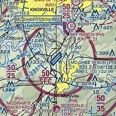
| Sectional chart |
|---|
|
 Download PDF
of official airport diagram from the FAA
| Airport distance calculator |
|---|
|
|
| Sunrise and sunset |
|---|
|
Times for 06-Jun-2026
| | Local
(UTC-4) | | Zulu
(UTC) |
|---|
| Morning civil twilight | | 05:51 | | 09:51 |
| Sunrise | | 06:21 | | 10:21 |
| Sunset | | 20:48 | | 00:48 |
| Evening civil twilight | | 21:18 | | 01:18 |
|
| Current date and time |
|---|
| Zulu (UTC) | 06-Jun-2026 07:01:08 |
|---|
| Local (UTC-4) | 06-Jun-2026 03:01:08 |
|---|
|
| METAR |
|---|
| KTYS | 060653Z 00000KT 10SM CLR 19/15 A3007 RMK AO2 SLP170 T01940150
|
KDKX
11nm NE | 060635Z AUTO 00000KT 8SM FEW044 17/16 A3008 RMK A01
|
KOQT
17nm NW | 060653Z AUTO 00000KT 10SM CLR 16/15 A3008 RMK AO2 SLP175 T01610150
|
|
| TAF |
|---|
| KTYS | 060520Z 0606/0706 VRB04KT P6SM SCT250 FM061500 23009KT P6SM FEW050 BKN200
|
|
| NOTAMs |
|---|
NOTAMs are issued by the DoD/FAA and will open in a separate window not controlled by AirNav.
|
|


