FAA INFORMATION EFFECTIVE 27 NOVEMBER 2025
Location
| FAA Identifier: | WAL |
| Lat/Long: | 37-56-24.7000N 075-27-59.0000W
37-56.411667N 075-27.983333W
37.9401944,-75.4663889
(estimated) |
| Elevation: | 40.2 ft. / 12.3 m (surveyed) |
| Variation: | 11W (2015) |
| From city: | 5 miles S of WALLOPS ISLAND, VA |
| Time zone: | UTC -5 (UTC -4 during Daylight Saving Time) |
| Zip code: | 23337 |
Airport Operations
| Airport use: | Private use. Permission required prior to landing |
| Activation date: | 07/1943 |
| Control tower: | yes |
| ARTCC: | WASHINGTON CENTER |
| FSS: | LEESBURG FLIGHT SERVICE STATION |
| NOTAMs facility: | WAL (NOTAM-D service available) |
| Attendance: | CONTINUOUS |
| Wind indicator: | lighted |
| Segmented circle: | no |
| Beacon: | white-green (lighted land airport)
FOR ROTG BCN CALL CTAF. |
Airport Communications
| CTAF: | 126.5 |
| WX ASOS: | 119.175 (757-824-0820) |
| WALLOPS GROUND: | 127.875 269.325 [OPR 1200-2200Z++ MON-FRI EXC FED HOL AND BY NOTAM.] |
| WALLOPS TOWER: | 126.5 306.975 [OPR 1200-2200Z++ MON-FRI EXC FED HOL AND BY NOTAM.] |
| PATUXENT APPROACH: | 127.95 |
| POTOMAC APPROACH: | 127.2 ;WHEN NHK APCH CLSD |
| PATUXENT DEPARTURE: | 127.95 |
| POTOMAC DEPARTURE: | 127.2 ;WHEN NHK APCH CLSD |
| CLEARANCE DELIVERY: | 121.7 |
- APCH/DEP SVC PRVDD BY POTOMAC TRACON 127.2/281.47 (0400-1200Z MON-FRI, 2300-1300Z SAT-SUN. OTHER TIMES BY NOTAM.) WHEN PATUXENT APCH CTL CLSD.
Airport Services
| Fuel available: | A |
| Oil available: | UHF CTAF - 306.975. |
| Airframe service: | NONE |
| Powerplant service: | NONE |
Runway Information
Runway 4/22
| Dimensions: | 8748 x 150 ft. / 2666 x 46 m |
| Surface: | asphalt/concrete, in good condition |
| Weight bearing capacity: | | Single wheel: | 57.0 | | Double wheel: | 115.0 | | Double tandem: | 225.0 |
|
| Runway edge lights: | high intensity |
| RUNWAY 4 | | RUNWAY 22 |
| Latitude: | 37-55.624190N | | 37-56.843975N |
| Longitude: | 075-28.256833W | | 075-27.287173W |
| Elevation: | 34.0 ft. | | 31.3 ft. |
| Traffic pattern: | left | | left |
| Runway heading: | 043 magnetic, 032 true | | 223 magnetic, 212 true |
| Markings: | nonprecision, in good condition | | nonprecision, in good condition |
| Visual slope indicator: | 4-light PAPI on left (3.00 degrees glide path) | | 4-light PAPI on left (3.00 degrees glide path) |
| Runway end identifier lights: | yes | | yes |
| Touchdown point: | yes, no lights | | yes, no lights |
Runway 10/28
| Dimensions: | 8005 x 200 ft. / 2440 x 61 m |
| Surface: | asphalt/concrete, in good condition |
| Weight bearing capacity: | | Single wheel: | 57.0 | | Double wheel: | 115.0 | | Double tandem: | 225.0 |
|
| Runway edge lights: | high intensity |
| RUNWAY 10 | | RUNWAY 28 |
| Latitude: | 37-56.576128N | | 37-56.567907N |
| Longitude: | 075-29.104492W | | 075-27.438973W |
| Elevation: | 19.4 ft. | | 35.2 ft. |
| Traffic pattern: | left | | left |
| Runway heading: | 101 magnetic, 090 true | | 281 magnetic, 270 true |
| Markings: | nonprecision, in good condition | | nonprecision, in good condition |
| Visual slope indicator: | 4-light PAPI on left (3.00 degrees glide path) | | 4-light PAPI on left (3.00 degrees glide path) |
| Runway end identifier lights: | yes | | yes |
| Touchdown point: | yes, no lights | | yes, no lights |
Runway 17/35
| Dimensions: | 4808 x 150 ft. / 1465 x 46 m |
| Surface: | asphalt, in good condition |
| Weight bearing capacity: | | Single wheel: | 15.0 | | Double wheel: | 40.0 | | Double tandem: | 75.0 |
|
| Runway edge lights: | high intensity |
| RUNWAY 17 | | RUNWAY 35 |
| Latitude: | 37-56.830780N | | 37-56.097798N |
| Longitude: | 075-28.075640W | | 075-27.696255W |
| Elevation: | 30.7 ft. | | 34.6 ft. |
| Traffic pattern: | left | | left |
| Runway heading: | 169 magnetic, 158 true | | 349 magnetic, 338 true |
| Markings: | nonprecision, in fair condition | | nonprecision, in fair condition |
| Visual slope indicator: | 4-light PAPI on left (3.00 degrees glide path) | | 4-light PAPI on left (3.00 degrees glide path) |
| Runway end identifier lights: | yes | | yes |
| Touchdown point: | yes, no lights | | yes, no lights |
Airport Ownership and Management from official FAA records
| Ownership: | Publicly-owned |
| Owner: | NASA
WALLOPS FLIGHT FACILITY
WALLOPS ISLAND, VA 23337
Phone 757-824-1240 |
| Manager: | ED SUDENDORF
WALLOPS FLIGHT FACILITY
WALLOPS ISLAND, VA 23337
Phone 757-824-2325 |
Additional Remarks
| A52-22 | 166 FT HIGH RADAR DISH 800 FT R OF APCH 22. |
| A52-28 | 510 FT CATV TWR 4 MI OFF APCH RWY 28. |
| E60-22 | HOOK E28(B) (1500 FT). |
| - | EXTENSIVE RESEARCH TEST DEVELOPMENT IN PROGRESS. |
| - | MILITARY TURBOPROP TRAINING DAILY UNTIL 2300L. |
| - | FCLP EQUIPMENT DIRECTLY ADJACENT TO LEFT SIDE OF RWY 10 1335-1725 FT FM APPROACH END. FCLP EQUIPMENT DIRECTLY ADJACENT TO LEFT SIDE OF RWY 28 1340-1725 FT FM APPROACH END. |
| - | TOUCH AND GO LDGS NA WHEN ATCT CLSD. |
| - | RWY 17/35 CLSD WHEN ATCT CLSD. |
| - | WHEN ATCT CLSD, 126.5 CTAF ONLY. EXPC NO RESP OR ADZY SVCS. |
| - | E-28 ARRESTING GEAR 1500 FT FM THE NORTH END OF RWY 22 IS RIGGED/IN BATTERY. |
| - | PPR 24 HR PN TO LDG, PHONE 757-824-1688. |
| - | FOR CD CTC PATUXENT APCH AT 301-342-3740, WHEN PATUXENT APCH IS CLSD CTC POTOMAC APCH AT 866-640-4124. |
| - | DEER & BIRDS ON AND INVOF ARPT. |
| - | NUMEROUS RADAR FACILITIES AT ARPT WITH POSSIBLE RADIO FREQUENCY HAZARD TO ORDNANCE. |
Instrument Procedures
NOTE: All procedures below are presented as PDF files. If you need a reader for these files, you should download the free Adobe Reader.NOT FOR NAVIGATION. Please procure official charts for flight.
FAA instrument procedures published for use from 27 November 2025 at 0901Z to 25 December 2025 at 0900Z.
IAPs - Instrument Approach Procedures |
|---|
| RNAV (GPS) RWY 04 **CHANGED** | |
download (276KB) |
| RNAV (GPS) RWY 10 **CHANGED** | |
download (287KB) |
| RNAV (GPS) RWY 17 **CHANGED** | |
download (295KB) |
| RNAV (GPS) RWY 22 **CHANGED** | |
download (289KB) |
| RNAV (GPS) RWY 28 **CHANGED** | |
download (289KB) |
| RNAV (GPS) RWY 35 **CHANGED** | |
download (290KB) |
| TACAN RWY 10 **NEW** | |
download (263KB) |
| NOTE: Special Alternate Minimums apply **CHANGED** | |
download (166KB) |
| NOTE: Special Take-Off Minimums/Departure Procedures apply | |
download (140KB) |
Other nearby airports with instrument procedures:
W41 - Crisfield-Somerset County Airport (18 nm W)
KMFV - Accomack County Airport (22 nm SW)
KSBY - Salisbury-Ocean City Wicomico Regional Airport (24 nm N)
KTGI - Tangier Island Airport (26 nm W)
KOXB - Ocean City Municipal Airport (27 nm NE)
|
|

Road maps at:
MapQuest
Bing
Google
| Aerial photo |
|---|
WARNING: Photo may not be current or correct
 Photo by Patrick J. Hendrickson / Highcamera.com
Taken in the Fall of 2015
looking north.
Photo by Patrick J. Hendrickson / Highcamera.com
Taken in the Fall of 2015
looking north.
Do you have a better or more recent aerial photo of Wallops Flight Facility that you would like to share? If so, please send us your photo.
|
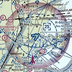
| Sectional chart |
|---|
|
 Download PDF
of official airport diagram from the FAA
| Airport distance calculator |
|---|
|
|
| Sunrise and sunset |
|---|
|
Times for 28-Nov-2025
| | Local
(UTC-5) | | Zulu
(UTC) |
|---|
| Morning civil twilight | | 06:28 | | 11:28 |
| Sunrise | | 06:57 | | 11:57 |
| Sunset | | 16:43 | | 21:43 |
| Evening civil twilight | | 17:12 | | 22:12 |
|
| Current date and time |
|---|
| Zulu (UTC) | 28-Nov-2025 05:59:28 |
|---|
| Local (UTC-5) | 28-Nov-2025 00:59:28 |
|---|
|
| METAR |
|---|
| KWAL | 280554Z AUTO 30007KT 10SM CLR 01/M07 A3005 RMK AO2 SLP172 T00111067 10050 20011 51002
|
|
| TAF |
|---|
KSBY
24nm N | 271730Z 2718/2818 28011G18KT P6SM BKN200 FM272300 30006KT P6SM BKN200 FM280300 28007KT P6SM SKC FM281400 28015G25KT P6SM SKC
|
|
| NOTAMs |
|---|
NOTAMs are issued by the DoD/FAA and will open in a separate window not controlled by AirNav.
|
|


