FAA INFORMATION EFFECTIVE 14 MAY 2026
Location
| FAA Identifier: | L78 |
| Lat/Long: | 32-36-57.1700N 116-09-55.9400W
32-36.952833N 116-09.932333W
32.6158806,-116.1655389
(estimated) |
| Elevation: | 2844 ft. / 867 m (estimated) |
| Variation: | 13E (1985) |
| From city: | 1 mile E of JACUMBA, CA |
| Time zone: | UTC -7 (UTC -8 during Standard Time) |
| Zip code: | 91934 |
Airport Operations
| Airport use: | Open to the public |
| Activation date: | 05/1941 |
| Control tower: | no |
| ARTCC: | LOS ANGELES CENTER |
| FSS: | SAN DIEGO FLIGHT SERVICE STATION |
| NOTAMs facility: | SAN (NOTAM-D service available) |
| Attendance: | UNATNDD |
| Wind indicator: | yes |
| Segmented circle: | yes |
Airport Communications
Nearby radio navigation aids
| VOR radial/distance | | VOR name | | Freq | | Var |
|---|
| IPLr242/34.1 | | IMPERIAL VORTAC | | 115.90 | | 14E |
| JLIr131/37.9 | | JULIAN VORTAC | | 113.75 | | 15E |
Airport Services
| Parking: | tiedowns |
| Airframe service: | NONE |
| Powerplant service: | NONE |
| Bottled oxygen: | NONE |
| Bulk oxygen: | NONE |
Runway Information
Runway 7/25
| Dimensions: | 2562 x 60 ft. / 781 x 18 m |
| Surface: | asphalt, in good condition |
| Weight bearing capacity: | |
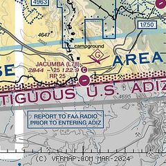
| Operational restrictions: | CLSD SS-SR, NOT LGTD. |
| RUNWAY 7 | | RUNWAY 25 |
| Latitude: | 32-36.926500N | | 32-36.979167N |
| Longitude: | 116-10.180000W | | 116-09.684667W |
| Traffic pattern: | left | | right
INTL BDRY TO S. |
| Markings: | basic, in good condition | | basic, in good condition |
| Runway end identifier lights: | no | | no |
| Obstructions: | none | | 480 ft. hill, 5000 ft. from runway, 10:1 slope to clear |
Airport Ownership and Management from official FAA records
| Ownership: | Publicly-owned |
| Owner: | COUNTY OF SAN DIEGO
1960 JOE CROSSON DRIVE
EL CAJON, CA 92020-1142
Phone 619-956-4800 |
| Manager: | CATHE JOHNSON
SAN DIEGO COUNTY AIRPORTS, CROSSON DRIVE
EL CAJON, CA 92020
Phone 619-956-4800 |
Additional Remarks
| - | ALL ACFT AVOID OVERFLIGHT US/MEXICAN BDR WO AUTH. |
| - | NOISE ABATEMENT; AVOID OVERFLYING RESIDENTIAL COMMUNITY 1/2 MI W. |
| - | RCMD RWY TO RAMP TRSN, ASPH TO SOFT DIRT, AT TWY STUB MIDFIELD, ALL OTHER AREAS ASPH TO GRVL. |
| - | HEL SKID/RUN-ON LDG AND AUTO-ROTATIONS PROHIBITED. |
| - | RDO EQUIPPPED ACFT SHALL SELF-ANNC ON CTAF PRIOR TO LDG OR TKOF. |
| - | PIN TO OBTAIN VEHICLE ACES TO ARPT, CALL 619-956-4800. |
| - | PPR ALL MIL ACFT CTC AMGR. |
| - | FOR CD CTC LOS ANGELES ARTCC AT 661-575-2079. |
| - | WIND PMTG, RCMD LAND RWY 07 AND DEPART RWY 25 DUE TO 480 FT HILL 1 MI E OF AP. |
| - | FRQ GLD ACT DRG WKENDS, PWRD ACFT BE ALERT FOR GLD TFC LAUNCHING FRM FLD AND OPERG ON AND IN VCNTY OF AP, SFC TO 18000 FT MSL. |
| - | RAPIDLY RISING TRRN ALL QUADS. |
| - | OCNL WILDLIFE ON AND IN VCNTY OF AP. |
| - | CONTIGUOUS ADIZ IN VCNTY AND ALONG INTL BDRY, LCTD APRXLY 615 FT S OF RWY 07-25. |
Instrument Procedures
There are no published instrument procedures at L78.
Some nearby airports with instrument procedures:
KNJK - El Centro NAF Airport (Vraciu Field) (28 nm NE)
KIPL - Imperial County Airport (32 nm NE)
L08 - Borrego Valley Airport (39 nm N)
KBWC - Brawley Municipal Airport (40 nm NE)
KSDM - Brown Field Municipal Airport (41 nm W)
|
|

Road maps at:
MapQuest
Bing
Google
| Aerial photo |
|---|
WARNING: Photo may not be current or correct
 Photo by Mark Holtzman
Photo taken 18-Apr-2017
looking west-southwest.
Photo by Mark Holtzman
Photo taken 18-Apr-2017
looking west-southwest.
Do you have a better or more recent aerial photo of Jacumba Airport that you would like to share? If so, please send us your photo.
|
| Sectional chart |
|---|
|
| Airport distance calculator |
|---|
|
|
| Sunrise and sunset |
|---|
|
Times for 30-May-2026
| | Local
(UTC-7) | | Zulu
(UTC) |
|---|
| Morning civil twilight | | 05:11 | | 12:11 |
| Sunrise | | 05:39 | | 12:39 |
| Sunset | | 19:45 | | 02:45 |
| Evening civil twilight | | 20:13 | | 03:13 |
|
| Current date and time |
|---|
| Zulu (UTC) | 31-May-2026 05:30:09 |
|---|
| Local (UTC-7) | 30-May-2026 22:30:09 |
|---|
|
| METAR |
|---|
KNJK
28nm NE | 310356Z AUTO 20007KT 10SM CLR 29/05 A2980 RMK AO2 SLP106 T02890050 $
|
|
| TAF |
|---|
KNJK
28nm NE | 301500Z 3015/3115 VRB06KT 9999 SKC QNH2975INS FM310400 25008KT 9999 SKC QNH2977INS FM311100 VRB06KT 9999 SKC QNH2977INS LAST NO AMDS AFT 3022 NEXT 0107 TX33/3101Z TN18/3113Z COR 1513 FS30238
|
KIPL
32nm NE | 301720Z 3018/3118 VRB04KT P6SM SKC FM310300 26007KT P6SM SKC FM311300 VRB03KT P6SM SKC
|
|
| NOTAMs |
|---|
NOTAMs are issued by the DoD/FAA and will open in a separate window not controlled by AirNav.
|
|

