FAA INFORMATION EFFECTIVE 30 OCTOBER 2025
Location
| FAA Identifier: | LBL |
| Lat/Long: | 37-02-38.1160N 100-57-35.8870W
37-02.635267N 100-57.598117W
37.0439211,-100.9599686
(estimated) |
| Elevation: | 2885.4 ft. / 879.5 m (surveyed) |
| Variation: | 06E (2015) |
| From city: | 2 miles W of LIBERAL, KS |
| Time zone: | UTC -5 (UTC -6 during Standard Time) |
| Zip code: | 67901 |
Airport Operations
| Airport use: | Open to the public |
| Activation date: | 02/1944 |
| Control tower: | no |
| ARTCC: | KANSAS CITY CENTER |
| FSS: | WICHITA FLIGHT SERVICE STATION |
| NOTAMs facility: | LBL (NOTAM-D service available) |
| Attendance: | MON-FRI 0600-2000, ALL SAT-SUN 0700-2000 |
| Wind indicator: | lighted |
| Segmented circle: | yes |
| Lights: | ACTVT MIRL RY 04/22 & HIRL RY 17/35; MALSR RY 35; VASI RYS 17 & 35; & PAPI RYS 04 & 22; REIL RYS 04, 17 & 22 - CTAF. |
| Beacon: | white-green (lighted land airport)
Operates sunset to sunrise. |
| Fire and rescue: | ARFF index A |
| Airline operations: | 24 HR PPR FOR UNSKED ACR OPNS WITH MORE THAN 30 PSGR SEATS CALL AMGR (620) 626-2207 OR (620) 626-0150. ACR OPNS OVER 9 PSGR SEATS NOT AUTH OVER 15 MINUTES BEFORE OR AFTER SKED ARR OR DEP TIMES EXCP WITH PRIOR COORD WITH AMGR OR FIRE DEPT. ARFF INDEX B IS PROVIDED. |
Airport Communications
| CTAF/UNICOM: | 122.8 |
| WX AWOS-3PT: | 118.375 (620-624-1221) |
- COMMUNICATIONS PRVDD BY WICHITA RADIO ON FREQ 122.4 (LIBERAL RCO).
- APCH/DEP CTL SVC PRVDD BY KANSAS CITY ARTCC (ZKC) ON FREQS 134.0/257.625 (LIBERAL RCAG).
Nearby radio navigation aids
| NDB name | | Hdg/Dist | | Freq | | Var | | ID |
|---|
| PANCK | | 352/4.8 | | 383 | | 06E | | LB | .-.. -... |
| GUYMON | | 043/33.1 | | 275 | | 09E | | GUY | --. ..- -.-- |
| PERRYTON | | 338/39.2 | | 266 | | 07E | | PYX | .--. -.-- -..- |
Airport Services
| Fuel available: | 100LL JET-A |
| Parking: | hangars and tiedowns |
| Airframe service: | MAJOR |
| Powerplant service: | MAJOR |
| Bottled oxygen: | NONE |
| Bulk oxygen: | LOW |
Runway Information
Runway 17/35
| Dimensions: | 7105 x 100 ft. / 2166 x 30 m |
| Surface: | concrete/grooved, in excellent condition |
| Weight bearing capacity: | | Single wheel: | 89.0 | | Double wheel: | 107.0 |
|
| Runway edge lights: | high intensity |
| RUNWAY 17 | | RUNWAY 35 |
| Latitude: | 37-03.236540N | | 37-02.065953N |
| Longitude: | 100-57.386167W | | 100-57.383572W |
| Elevation: | 2877.7 ft. | | 2874.6 ft. |
| Traffic pattern: | left | | left |
| Runway heading: | 174 magnetic, 180 true | | 354 magnetic, 360 true |
| Declared distances: | TORA:7105 TODA:7105 ASDA:7105 LDA:7105 | | TORA:7105 TODA:7105 ASDA:7105 LDA:7105 |
| Markings: | nonprecision, in good condition | | precision, in good condition |
| Visual slope indicator: | 4-box VASI on left (3.00 degrees glide path) | | 4-box VASI on left (3.00 degrees glide path) |
| Approach lights: | | | MALSR: 1,400 foot medium intensity approach lighting system with runway alignment indicator lights |
| Runway end identifier lights: | yes | | |
| Touchdown point: | yes, no lights | | yes, no lights |
| Instrument approach: | | | ILS |
Runway 4/22
| Dimensions: | 5000 x 75 ft. / 1524 x 23 m |
| Surface: | concrete, in excellent condition |
| Weight bearing capacity: | | Single wheel: | 35.0 | | Double wheel: | 44.0 |
|
| Runway edge lights: | medium intensity |
| RUNWAY 4 | | RUNWAY 22 |
| Latitude: | 37-02.320803N | | 37-02.904293N |
| Longitude: | 100-58.263870W | | 100-57.538262W |
| Elevation: | 2885.4 ft. | | 2878.4 ft. |
| Traffic pattern: | left | | left |
| Runway heading: | 039 magnetic, 045 true | | 219 magnetic, 225 true |
| Declared distances: | TORA:5000 TODA:5000 ASDA:5000 LDA:5000 | | TORA:5000 TODA:5000 ASDA:5000 LDA:5000 |
| Markings: | nonprecision, in good condition | | nonprecision, in good condition |
| Visual slope indicator: | 4-light PAPI on left (3.00 degrees glide path) | | 4-light PAPI on left (3.00 degrees glide path) |
| Runway end identifier lights: | yes | | yes |
| Touchdown point: | yes, no lights | | yes, no lights |
Airport Ownership and Management from official FAA records
| Ownership: | Publicly-owned |
| Owner: | CITY OF LIBERAL
PO BOX 2199
LIBERAL, KS 67905-2199
Phone 620-626-2207 |
| Manager: | MR. BRIAN FORNWALT
PO BOX 2199
LIBERAL, KS 67905-2199
Phone (620) 626-0188 |
Additional Remarks
| A39-04/22 | PCR VALUE: 110/R/D/W/T |
| A39-17/35 | PCR VALUE: 340/R/C/W/T |
| - | FOR CD IF UNA TO CTC ON FSS FREQ, CTC KANSAS CITY ARTCC AT 913-254-8508. |
Instrument Procedures
NOTE: All procedures below are presented as PDF files. If you need a reader for these files, you should download the free Adobe Reader.NOT FOR NAVIGATION. Please procure official charts for flight.
FAA instrument procedures published for use from 30 October 2025 at 0901Z to 27 November 2025 at 0900Z.
IAPs - Instrument Approach Procedures |
|---|
| ILS OR LOC RWY 35 **CHANGED** | |
download (193KB) |
| RNAV (GPS) RWY 04 **CHANGED** | |
download (241KB) |
| RNAV (GPS) RWY 17 **CHANGED** | |
download (250KB) |
| RNAV (GPS) RWY 22 **CHANGED** | |
download (246KB) |
| RNAV (GPS) RWY 35 **CHANGED** | |
download (248KB) |
| NOTE: Special Alternate Minimums apply | |
download (147KB) |
| NOTE: Special Take-Off Minimums/Departure Procedures apply | |
download (188KB) |
Other nearby airports with instrument procedures:
KHQG - Hugoton Municipal Airport (21 nm W)
KMEJ - Meade Municipal Airport (32 nm NE)
KGUY - Guymon Municipal Airport (34 nm SW)
KULS - Ulysses Airport (39 nm NW)
KPYX - Perryton Ochiltree County Airport (39 nm S)
|
|

Road maps at:
MapQuest
Bing
Google
| Aerial photo |
|---|
WARNING: Photo may not be current or correct
 Photo by Von Rothenberger
Photo taken 14-Aug-2010
looking north.
Photo by Von Rothenberger
Photo taken 14-Aug-2010
looking north.
Do you have a better or more recent aerial photo of Liberal Mid-America Regional Airport that you would like to share? If so, please send us your photo.
|
| Sectional chart |
|---|
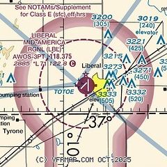
|
CAUTION: Diagram may not be current
 Download PDF
of official airport diagram from the FAA
| Airport distance calculator |
|---|
|
|
| Sunrise and sunset |
|---|
|
Times for 31-Oct-2025
| | Local
(UTC-5) | | Zulu
(UTC) |
|---|
| Morning civil twilight | | 07:41 | | 12:41 |
| Sunrise | | 08:08 | | 13:08 |
| Sunset | | 18:47 | | 23:47 |
| Evening civil twilight | | 19:14 | | 00:14 |
|
| Current date and time |
|---|
| Zulu (UTC) | 01-Nov-2025 04:51:51 |
|---|
| Local (UTC-5) | 31-Oct-2025 23:51:51 |
|---|
|
| METAR |
|---|
| KLBL | 010356Z AUTO 03010KT 10SM CLR 06/01 A3014 RMK AO2 SLP208 T00610011 PNO $
|
|
| TAF |
|---|
| KLBL | 311720Z 3118/0118 12005KT P6SM BKN210 FM010000 06007KT P6SM OVC180
|
|
| NOTAMs |
|---|
NOTAMs are issued by the DoD/FAA and will open in a separate window not controlled by AirNav.
|
|


