FAA INFORMATION EFFECTIVE 22 JANUARY 2026
Location
| FAA Identifier: | LCK |
| Lat/Long: | 39-48-49.6332N 082-55-40.1294W
39-48.827220N 082-55.668823W
39.8137870,-82.9278137
(estimated) |
| Elevation: | 743.9 ft. / 226.7 m (surveyed) |
| Variation: | 07W (2010) |
| From city: | 10 miles S of COLUMBUS, OH |
| Time zone: | UTC -5 (UTC -4 during Daylight Saving Time) |
| Zip code: | 43125 |
Airport Operations
| Airport use: | Open to the public |
| Activation date: | 07/1943 |
| Control tower: | yes |
| ARTCC: | INDIANAPOLIS CENTER |
| FSS: | DAYTON FLIGHT SERVICE STATION |
| NOTAMs facility: | LCK (NOTAM-D service available) |
| Attendance: | CONTINUOUS |
| Pattern altitude: | TPA FOR LIGHT ACFT WEIGHING 12500 LBS OR LESS 656'; TPA FOR ACFT GREATER THAN 12500 LBS 1156'; TPA FOR OVERHEAD TFC 1656'. |
| Wind indicator: | lighted |
| Segmented circle: | no |
| Beacon: | white-green (lighted land airport)
Operates sunset to sunrise. |
| Landing fee: | yes |
| Fire and rescue: | ARFF index B |
| Airline operations: | CLASS I, ARFF INDEX B. INDEX E ARFF EQUIP AVBL UPON REQUEST, CTC ARPT OPNS (614) 374-1869. |
| International operations: | customs landing rights airport
TO REQUEST LANDING RIGHTS CTC US CUSTOMS BTN 0730-2200
MON-FRI AT 614-497-1865. |
Airport Communications
| UNICOM: | 122.95 |
| ATIS: | 132.75 |
| WX AWOS-3: | PHONE 614-492-2441 |
| RICK TOWER GROUND: | 125.275 275.8 |
| RICK TOWER TOWER: | 120.05 348.4 |
| COLUMBUS APPROACH: | 134.0 |
| COLUMBUS DEPARTURE: | 134.0 |
| CLEARANCE DELIVERY: | 125.275 275.8 |
| ARNG OPS: | 123.09 142.6 228.8 36.7FM |
| CBUSS STAR: | 125.95 |
| COMD POST: | 238.8 252.1 311.0 |
| DUBLN STAR: | 125.95 |
| EMERG: | 121.5 243.0 |
| IC: | 134.0 |
| NG OPS: | 311.3 |
| OPS: | 139.3 ;ARNG C-26 CALL TORSO OPS |
| WX AWOS-3PT at TZR (11 nm NW): | 135.925 (614-878-1722) |
| WX ASOS at CMH (11 nm N): | 124.6 (614-333-9354) |
| WX ASOS at LHQ (13 nm E): | 118.375 (740-681-1097) |
| WX ASOS at OSU (17 nm NW): | 121.35 (614-451-2465) |
- CTC GND CON FOR CLNC PRIOR TO PUSHBACK ON CARGO RAMP 2.
Nearby radio navigation aids
| VOR radial/distance | | VOR name | | Freq | | Var |
|---|
| XUBr013/(17.4) | | YELLOW BUD VOR | | 112.50 | | 05W |
| APEr224/25.6 | | APPLETON VORTAC | | 116.70 | | 06W |
| NDB name | | Hdg/Dist | | Freq | | Var | | ID |
|---|
| PICKL | | 233/5.8 | | 376 | | 07W | | LC | .-.. -.-. |
| COBBS | | 052/6.0 | | 253 | | 07W | | DD | -.. -.. |
| BOUTN | | 096/12.8 | | 230 | | 05W | | BU | -... ..- |
| COURT HOUSE | | 065/24.9 | | 414 | | 06W | | CSS | -.-. ... ... |
Airport Services
| Fuel available: | 100LL JET-A JET-A++ |
| Parking: | hangars and tiedowns |
| Airframe service: | MAJOR |
| Powerplant service: | MAJOR |
Runway Information
Runway 5R/23L
| Dimensions: | 12103 x 200 ft. / 3689 x 61 m |
| Surface: | asphalt/concrete/grooved, in excellent condition |
| Weight bearing capacity: | | Single wheel: | 120.0 | | Double wheel: | 230.0 | | Double tandem: | 449.0 | | Dual double tandem: | 973.0 |
|
| Runway edge lights: | high intensity |
| RUNWAY 5R | | RUNWAY 23L |
| Latitude: | 39-48.063900N | | 39-49.465875N |
| Longitude: | 082-56.518753W | | 082-54.681142W |
| Elevation: | 734.8 ft. | | 739.5 ft. |
| Traffic pattern: | left | | left |
| Runway heading: | 052 magnetic, 045 true | | 232 magnetic, 225 true |
| Declared distances: | TORA:12103 TODA:12103 ASDA:12103 LDA:12103 | | TORA:12103 TODA:12103 ASDA:12103 LDA:12103 |
| Markings: | precision, in good condition | | precision, in good condition |
| Visual slope indicator: | 4-light PAPI on left (3.00 degrees glide path) | | 4-light PAPI on left (3.00 degrees glide path) |
| RVR equipment: | touchdown | | touchdown |
| Approach lights: | ALSF2: standard 2,400 foot high intensity approach lighting system with centerline sequenced flashers (category II or III) | | MALSR: 1,400 foot medium intensity approach lighting system with runway alignment indicator lights |
| Centerline lights: | yes | | yes |
| Touchdown point: | yes, lighted | | yes, no lights |
| Instrument approach: | ILS/DME | | ILS |
Runway 5L/23R
| Dimensions: | 11902 x 150 ft. / 3628 x 46 m |
| Surface: | asphalt/grooved, in fair condition |
| Weight bearing capacity: | | Single wheel: | 120.0 | | Double wheel: | 195.0 | | Double tandem: | 368.0 | | Dual double tandem: | 854.0 |
|
| Runway edge lights: | high intensity |
| RUNWAY 5L | | RUNWAY 23R |
| Latitude: | 39-48.201255N | | 39-49.579945N |
| Longitude: | 082-56.642443W | | 082-54.835283W |
| Elevation: | 735.5 ft. | | 737.3 ft. |
| Traffic pattern: | left | | left |
| Runway heading: | 052 magnetic, 045 true | | 232 magnetic, 225 true |
| Displaced threshold: | 898 ft. | | 989 ft. |
| Declared distances: | TORA:11902 TODA:11902 ASDA:11902 LDA:11004 | | TORA:11902 TODA:11902 ASDA:11902 LDA:10913 |
| Markings: | precision, in good condition | | precision, in good condition |
| Visual slope indicator: | 4-light PAPI on left (3.00 degrees glide path) | | 4-light PAPI on left (3.00 degrees glide path) |
| Approach lights: | MALSR: 1,400 foot medium intensity approach lighting system with runway alignment indicator lights | | |
| Runway end identifier lights: | no | | yes |
| Touchdown point: | yes, no lights | | yes, no lights |
| Instrument approach: | ILS/DME | | |
Helipad H1
| Dimensions: | 50 x 50 ft. / 15 x 15 m |
| Surface: | concrete |
| Latitude: | 39-48.231667N | | |
| Longitude: | 082-56.916500W | | |
| Elevation: | 728.0 ft. | | |
| Traffic pattern: | left | | left |
Airport Ownership and Management from official FAA records
| Ownership: | Publicly-owned |
| Owner: | COLUMBUS RGNL AIRPORT AUTHORITY
4600 INTERNATIONAL GTWY
COLUMBUS, OH 43219-1779
Phone 614-239-4000 |
| Manager: | JOSEPH NARDONE
7250 STAR CHECK DR
COLUMBUS, OH 43217-1025
Phone 614-239-4000 |
Additional Remarks
| A39-05L/23R | PCR VALUE: 581/R/A/W/T |
| A39-05R/23L | PCR VALUE: 708/R/A/W/T |
| - | RSTD: ALL F/W MIL ACFT REQUIRING PARKING AND/OR SERVICE ON 121 ARW RAMP MUST HAVE PPR NR 48 HR PRIOR FR BASE OPS CALL DSN 696-4595 OR C614-492-4595. |
| - | RSTD; AMC ACFT OPR RSTD DUR BIRD WATCH CONDITION MODERATE (TKOF AND LDG PERMS ONLY WHEN DEP/ARR RTE AVOID IDENT BIRD ACT, NO LCL IFR/VFR TFC PAT) AND SEVERE(TKOF AND LDG PROH WO OG/CC APVL). CTC COMD POST FOR CURRENT BIRD WATCH COND CODE. |
| - | ANG; 121 ARW KC-135 R COMD POST DSN696-4468. LTD TRAN SVC AVBL , WKD 1200-2000++ EXE HOL. LTD TRAN FUEL/PRK, TRAN AIRCREW MUST ASSIST/PERFORM REFUEL OPR. FUEL AVBL ON ANG RAMP ON PRIOR REQ ONLY. ACFT SUPPORT NOT COORD BY PPR 48 HR PRIOR WITH 121 ARW MAY NOT BE AVBL. |
| - | ARNG; OPR 1200-2100Z++ WKD EXC HOL. NO TRAN SVC AFTER 1900Z++, DSN346-6411,C614-336-6411. |
| - | REMARK; SEE FLIP AP/1 SUPPLEMENTARY ARPT RMK. |
| - | LGT; BDRY LGT AVBL. |
| - | JASU: 6(A/M32A-86) 9(B809) 4(AM32-95). |
| - | FLUID: SP PRESAIR LHOX. |
| - | OIL; O-128. |
| - | TRAN ALERT: LTD SVC AVBL BUT NO PPR RQR. NO ANG TRAN SVC OFF ANG RAMP. |
| - | ARNG; CTC C-26 OPS PRIOR TO ENTERING C-26 RAMP/PARKING AREA. DSN346-6473, C6143366473. |
| - | BIRDS ON & INVOF ARPT. |
| - | CONTACT GND CTL FOR CLNC PRIOR TO PUSHBACK ONTO TWY 'A' FM CARGO RAMP 2. |
| - | NOISE ABATEMENT PROC IN EFCT FM 2300-0700; DEP RWY 23L & 23R WINDS 10 KNOTS OR LESS; ARR RWY 05L & 05R WINDS 10 KNOTS OR LESS; ARPT OPS 614-374-1869. |
Instrument Procedures
NOTE: All procedures below are presented as PDF files. If you need a reader for these files, you should download the free Adobe Reader.NOT FOR NAVIGATION. Please procure official charts for flight.
FAA instrument procedures published for use from 22 January 2026 at 0901Z to 19 February 2026 at 0900z.
STARs - Standard Terminal Arrivals |
|---|
| CBUSS TWO (RNAV) | |
2 pages:
[1] [2] (386KB) |
| CLPRR THREE (RNAV) | |
2 pages:
[1] [2] (319KB) |
| CLPRR THREE (RNAV) | |
2 pages:
[1] [2] (319KB) |
| DUBLN ONE (RNAV) | |
2 pages:
[1] [2] (380KB) |
| JAKTZ TWO (RNAV) | |
2 pages:
[1] [2] (381KB) |
| SCRLT TWO (RNAV) | |
2 pages:
[1] [2] (360KB) |
| SCRLT TWO (RNAV) | |
2 pages:
[1] [2] (360KB) |
IAPs - Instrument Approach Procedures |
|---|
| ILS OR LOC RWY 05L **CHANGED** | |
download (307KB) |
| ILS OR LOC RWY 05R **CHANGED** | |
download (235KB) |
| ILS OR LOC RWY 23L **CHANGED** | |
download (255KB) |
| ILS RWY 05R (SA CAT I) **CHANGED** | |
download (216KB) |
| ILS RWY 05R (CAT II) **CHANGED** | |
download (208KB) |
| RNAV (GPS) RWY 05L **CHANGED** | |
download (267KB) |
| RNAV (GPS) RWY 05R **CHANGED** | |
download (289KB) |
| RNAV (GPS) RWY 23L **CHANGED** | |
download (272KB) |
| RNAV (GPS) RWY 23R **CHANGED** | |
download (264KB) |
| NOTE: Special Alternate Minimums apply | |
download (131KB) |
Other nearby airports with instrument procedures:
KTZR - Bolton Field Airport (11 nm NW)
KCMH - John Glenn Columbus International Airport (11 nm N)
KLHQ - Fairfield County Airport (13 nm E)
KOSU - Ohio State University Airport (17 nm NW)
KCYO - Pickaway County Memorial Airport (18 nm S)
|
|

Road maps at:
MapQuest
Bing
Google
| Aerial photo |
|---|
WARNING: Photo may not be current or correct
 Photo courtesy of AirNav, LLC
Taken in 2014
looking southwest.
Photo courtesy of AirNav, LLC
Taken in 2014
looking southwest.
Do you have a better or more recent aerial photo of Rickenbacker International Airport that you would like to share? If so, please send us your photo.
|
| Sectional chart |
|---|
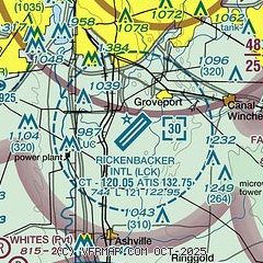
|
CAUTION: Diagram may not be current
 Download PDF
of official airport diagram from the FAA
| Airport distance calculator |
|---|
|
|
| Sunrise and sunset |
|---|
|
Times for 19-Feb-2026
| | Local
(UTC-5) | | Zulu
(UTC) |
|---|
| Morning civil twilight | | 06:53 | | 11:53 |
| Sunrise | | 07:20 | | 12:20 |
| Sunset | | 18:11 | | 23:11 |
| Evening civil twilight | | 18:39 | | 23:39 |
|
| Current date and time |
|---|
| Zulu (UTC) | 19-Feb-2026 05:53:47 |
|---|
| Local (UTC-5) | 19-Feb-2026 00:53:47 |
|---|
|
| METAR |
|---|
| KLCK | 190455Z AUTO 17005KT 10SM CLR 11/10 A2977 RMK AO2 T01090102
|
KTZR
10nm NW | 190535Z AUTO 19003KT 2 1/2SM BR CLR 09/09 A2978 RMK AO2 T00910090
|
KCMH
11nm N | 190540Z 00000KT 4SM R28L/3000VP6000FT BR BKN008 BKN250 09/09 A2977 RMK AO2 T00890089
|
KLHQ
13nm E | 190453Z AUTO 18004KT 10SM CLR 11/11 A2978 RMK AO2 SLP084 T01060106 401780067
|
KOSU
18nm NW | 190533Z AUTO 00000KT 2SM BR FEW065 09/09 A2977 RMK AO2 T00940089
|
|
| TAF |
|---|
| KLCK | 181942Z 1820/1918 24014G24KT P6SM BKN022 FM182100 22009KT P6SM SCT025 FM190300 18004KT P6SM BKN250 TEMPO 1908/1912 2SM BR SCT015 FM191500 13007KT P6SM BKN015
|
KCMH
11nm N | 181944Z 1820/1918 24012G22KT P6SM BKN025 FM182100 22008KT P6SM SCT025 FM190300 18004KT P6SM BKN250 TEMPO 1908/1912 2SM BR SCT015 FM191500 13007KT P6SM BKN015
|
|
| NOTAMs |
|---|
NOTAMs are issued by the DoD/FAA and will open in a separate window not controlled by AirNav.
|
|


