FAA INFORMATION EFFECTIVE 19 MARCH 2026
Location
| FAA Identifier: | LFT |
| Lat/Long: | 30-12-18.0960N 091-59-15.9140W
30-12.301600N 091-59.265233W
30.2050267,-91.9877539
(estimated) |
| Elevation: | 40.9 ft. / 12.5 m (surveyed) |
| Variation: | 03E (1990) |
| From city: | 2 miles SE of LAFAYETTE, LA |
| Time zone: | UTC -5 (UTC -6 during Standard Time) |
| Zip code: | 70508 |
Airport Operations
| Airport use: | Open to the public |
| Activation date: | 04/1940 |
| Control tower: | yes |
| ARTCC: | HOUSTON CENTER |
| FSS: | DE RIDDER FLIGHT SERVICE STATION |
| NOTAMs facility: | LFT (NOTAM-D service available) |
| Attendance: | CONTINUOUS |
| Wind indicator: | lighted |
| Segmented circle: | yes |
| Lights: | DUSK-DAWN. WHEN ATCT CLSD ACTVT MALSR RWY 22L - CTAF; MIRL RWY 04L/22R NOT AVBL. |
| Beacon: | white-green (lighted land airport)
Operates sunset to sunrise. |
| Fire and rescue: | ARFF index B |
| Airline operations: | PPR FOR UNSCHEDULED ACR OPNS WITH MORE THAN 30 PSGR SEATS CALL AMGR 337-703-4800. |
| International operations: | customs landing rights airport |
Airport Communications
| CTAF: | 118.5 |
| UNICOM: | 122.95 |
| ATIS: | 134.05 |
| WX ASOS: | 134.05 (337-262-2757) |
| LAFAYETTE GROUND: | 121.8 [0530-2230] |
| LAFAYETTE TOWER: | 118.5 257.8 [0530-2230] |
| LAFAYETTE APPROACH: | 121.1 ;020-210 128.7 ;211-019 268.7 ;211-019 363.0 ;020-210 [0530-2230] |
| LAFAYETTE DEPARTURE: | 121.1 ;020-210 128.7 ;211-019 268.7 ;211-019 363.0 ;020-210 [0530-2230] |
| CLEARANCE DELIVERY: | 125.55 |
| CLASS C: | 121.1 ;020-210 128.7 ;211-019 268.7 ;211-019 363.0 ;020-210 |
| EMERG: | 121.5 243.0 |
| IC: | 121.1 ;020-210 363.0 ;020-210 |
| WX ASOS at ARA (11 nm SE): | 133.325 (337-365-0128) |
| WX AWOS-3PT at IYA (15 nm S): | 118.875 (337-892-0526) |
- APCH/DEP SVC PRVDD BY HOUSTON ARTCC (ZHU) ON FREQS 126.35/338.25 (LAFAYETTE RCAG) WHEN LAFAYETTE APCH CTL (LFT) CLSD.
Nearby radio navigation aids
| VOR radial/distance | | VOR name | | Freq | | Var |
|---|
| LFT at field | | LAFAYETTE VORTAC | | 109.80 | | 03E |
| LLAr028/38.2 | | WHITE LAKE VOR/DME | | 114.95 | | 04E |
| LSUr239/39.7 | | FIGHTING TIGER VORTAC | | 116.50 | | 06E |
| NDB name | | Hdg/Dist | | Freq | | Var | | ID |
|---|
| LAFFS | | 216/6.5 | | 375 | | 03E | | LF | .-.. ..-. |
| ABBEVILLE | | 037/11.1 | | 230 | | 02E | | BNZ | -... -. --.. |
Airport Services
| Fuel available: | 100LL JET-A JET-A+
A+:CALL 337-234-3100. |
| Parking: | hangars and tiedowns |
| Airframe service: | MAJOR |
| Powerplant service: | MAJOR |
| Bottled oxygen: | LOW |
| Bulk oxygen: | HIGH |
Runway Information
Runway 4R/22L
| Dimensions: | 8000 x 150 ft. / 2438 x 46 m |
| Surface: | asphalt/grooved, in good condition |
| Weight bearing capacity: | | Single wheel: | 140.0 | | Double wheel: | 170.0 | | Double tandem: | 290.0 |
|
| Runway edge lights: | high intensity |
| RUNWAY 4R | | RUNWAY 22L |
| Latitude: | 30-11.753718N | | 30-12.782905N |
| Longitude: | 091-59.624208W | | 091-58.672947W |
| Elevation: | 38.2 ft. | | 31.9 ft. |
| Traffic pattern: | right | | left |
| Runway heading: | 036 magnetic, 039 true | | 216 magnetic, 219 true |
| Displaced threshold: | no | | 342 ft. |
| Declared distances: | TORA:8000 TODA:8000 ASDA:8000 LDA:8000 | | TORA:8000 TODA:8000 ASDA:8000 LDA:7659 |
| Markings: | precision, in good condition | | precision, in good condition |
| Visual slope indicator: | 4-light PAPI on left (3.00 degrees glide path) | | 4-light PAPI on left (3.00 degrees glide path) |
| RVR equipment: | rollout | | touchdown |
| Approach lights: | | | MALSR: 1,400 foot medium intensity approach lighting system with runway alignment indicator lights |
| Runway end identifier lights: | yes | | |
| Touchdown point: | yes, no lights | | yes, no lights |
| Instrument approach: | ILS/DME | | ILS/DME |
| Obstructions: | 49 ft. pole, 1843 ft. from runway, 325 ft. right of centerline, 34:1 slope to clear | | 57 ft. trees, 1066 ft. from runway, 214 ft. right of centerline, 36:1 slope to clear |
Runway 11/29
| Dimensions: | 5403 x 150 ft. / 1647 x 46 m |
| Surface: | asphalt/grooved, in good condition |
| Weight bearing capacity: | | Single wheel: | 85.0 | | Double wheel: | 110.0 | | Double tandem: | 175.0 |
|
| Runway edge lights: | medium intensity |
| RUNWAY 11 | | RUNWAY 29 |
| Latitude: | 30-12.458877N | | 30-12.153885N |
| Longitude: | 091-59.888135W | | 091-58.923942W |
| Elevation: | 36.5 ft. | | 33.9 ft. |
| Traffic pattern: | right | | left |
| Runway heading: | 107 magnetic, 110 true | | 287 magnetic, 290 true |
| Displaced threshold: | no | | 248 ft. |
| Declared distances: | TORA:5403 TODA:5403 ASDA:5403 LDA:5403 | | TORA:5403 TODA:5403 ASDA:5403 LDA:5155 |
| Markings: | nonprecision, in good condition | | nonprecision, in good condition |
| Visual slope indicator: | 4-light PAPI on left (3.00 degrees glide path) | | 4-light PAPI on left (3.00 degrees glide path) |
| Runway end identifier lights: | yes | | yes |
| Touchdown point: | yes, no lights | | yes, no lights |
| Obstructions: | 30 ft. trees, 1082 ft. from runway, 134 ft. right of centerline, 29:1 slope to clear | | 49 ft. tree, 1878 ft. from runway, 302 ft. right of centerline, 34:1 slope to clear |
Runway 4L/22R
| Dimensions: | 4098 x 75 ft. / 1249 x 23 m |
| Surface: | asphalt, in fair condition |
| Weight bearing capacity: | | PCN 11 /F/D/X/T | | Single wheel: | 25.0 | | Double wheel: | 32.0 |
|
| Runway edge lights: | medium intensity |
| Operational restrictions: | RWY 04L/22R NOT AVBL FOR PART 121/PART 380 OPS WITH SKED PAX CARRYING OPS MORE THAN 9 PAX SEATS AND NON-SKED PAX CARRYING OPS MORE THAN 30 PAX SEATS. RWY CLSD 2230-0530. |
| RUNWAY 4L | | RUNWAY 22R |
| Latitude: | 30-12.096748N | | 30-12.623732N |
| Longitude: | 091-59.550995W | | 091-59.063527W |
| Elevation: | 40.2 ft. | | 40.7 ft. |
| Traffic pattern: | left | | right |
| Runway heading: | 036 magnetic, 039 true | | 216 magnetic, 219 true |
| Declared distances: | TORA:4098 TODA:4098 ASDA:4098 LDA:4098 | | TORA:4098 TODA:4098 ASDA:4098 LDA:4098 |
| Markings: | nonprecision, in fair condition | | nonprecision, in fair condition |
| Visual slope indicator: | 2-light PAPI on left (3.00 degrees glide path) | | 2-light PAPI on left (3.00 degrees glide path) |
| Runway end identifier lights: | yes | | yes |
| Touchdown point: | yes, no lights | | yes, no lights |
| Obstructions: | 27 ft. tree, 996 ft. from runway, 83 ft. left of centerline, 29:1 slope to clear | | 54 ft. tree, 2364 ft. from runway, 5 ft. right of centerline, 40:1 slope to clear |
Airport Ownership and Management from official FAA records
| Ownership: | Publicly-owned |
| Owner: | CITY PARISH OF LAFAYETTE
200 TERMINAL DRIVE, SUITE 200
LAFAYETTE, LA 70508
Phone 337-703-4800 |
| Manager: | STEVEN L. PICOU, EXECUTIVE DIRECTOR
200 TERMINAL DRIVE, SUITE 200
LAFAYETTE, LA 70508-2124
Phone 337-703-4800 |
Additional Remarks
| A39-11/29 | PCR VALUE: 720/F/D/X/T |
| A39-04R/22L | PCR VALUE: 670/F/B/X/T |
| E60-11 | ENGINEERED MATERIALS ARRESTING SYSTEM (EMAS) 300 FT IN LENGTH BY 170 FT IN WIDTH LCTD AT THE DER 11. |
| E60-22L | ENGINEERED MATERIALS ARRESTING SYSTEM (EMAS) 380.7 FT IN LENGTH BY 170 FT IN WIDTH LCTD AT THE DER 22L. |
| E60-29 | ENGINEERED MATERIALS ARRESTING SYSTEM (EMAS) 448 FT IN LENGTH BY 170 FT IN WIDTH LCTD AT THE DER 29. |
| E60-04R | ENGINEERED MATERIALS ARRESTING SYSTEM (EMAS) 223 FT IN LENGTH BY 170 FT IN WIDTH LCTD AT THE DER 04R. |
| - | RWY 11/29; RWY 04L/22R & RWY 04R/22L LGTD DISTANCE REMAINING SIGNS. |
| - | CTC GND CTL PRIOR TO PUSH BACK FM TERMINAL. |
| - | USE CTN TWR BLIND SPOTS ON TWY M EAST & WEST OF TWY E. |
| - | FOR CD IF UNA TO CTC ON FSS FREQ, CTC HOUSTON ARTCC AT 281-230-5622. |
| - | TAXILANE A AND ALL PRKG RAMPS ARE NON-MOVEMENT AREAS. |
| - | ATCT HAS LTD VIS OF NORTH PRKG RAMP. |
| - | 155 FT OIL RIG 1 NM SE OF ARPT. |
| - | MIGRATORY BIRDS ON & INVOF ARPT. |
Instrument Procedures
NOTE: All procedures below are presented as PDF files. If you need a reader for these files, you should download the free Adobe Reader.NOT FOR NAVIGATION. Please procure official charts for flight.
FAA instrument procedures published for use from 19 March 2026 at 0901Z to 16 April 2026 at 0900Z.
IAPs - Instrument Approach Procedures |
|---|
| ILS OR LOC RWY 04R **CHANGED** | |
download (251KB) |
| ILS OR LOC RWY 22L **CHANGED** | |
download (318KB) |
| RNAV (GPS) RWY 04R | |
download (208KB) |
| RNAV (GPS) RWY 22L **CHANGED** | |
download (292KB) |
| RNAV (GPS) RWY 29 **CHANGED** | |
download (265KB) |
| VOR/DME RWY 11 | |
download (225KB) |
| NOTE: Special Alternate Minimums apply **CHANGED** | |
download (144KB) |
| NOTE: Special Take-Off Minimums/Departure Procedures apply | |
download (331KB) |
Other nearby airports with instrument procedures:
KARA - Acadiana Regional Airport (11 nm SE)
KIYA - Abbeville Chris Crusta Memorial Airport (15 nm S)
KOPL - St Landry Parish Airport (22 nm N)
4R7 - Eunice Airport (27 nm NW)
3R7 - Jennings Airport (36 nm W)
|
|

Road maps at:
MapQuest
Bing
Google
| Aerial photo |
|---|
WARNING: Photo may not be current or correct
 Photo by Cody Thibodeaux
Photo taken 26-Jan-2019
looking north.
Photo by Cody Thibodeaux
Photo taken 26-Jan-2019
looking north.
Do you have a better or more recent aerial photo of Lafayette Regional Airport/Paul Fournet Field that you would like to share? If so, please send us your photo.
|
| Sectional chart |
|---|
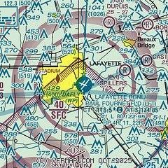
|
 Download PDF
of official airport diagram from the FAA
| Airport distance calculator |
|---|
|
|
| Sunrise and sunset |
|---|
|
Times for 31-Mar-2026
| | Local
(UTC-5) | | Zulu
(UTC) |
|---|
| Morning civil twilight | | 06:35 | | 11:35 |
| Sunrise | | 06:59 | | 11:59 |
| Sunset | | 19:25 | | 00:25 |
| Evening civil twilight | | 19:49 | | 00:49 |
|
| Current date and time |
|---|
| Zulu (UTC) | 31-Mar-2026 06:40:39 |
|---|
| Local (UTC-5) | 31-Mar-2026 01:40:39 |
|---|
|
| METAR |
|---|
| KLFT | 310553Z 00000KT 10SM BKN017 21/19 A3013 RMK AO2 SLP203 T02060189 10244 20206 402830200 58005
|
KARA
12nm SE | 310553Z AUTO 16005KT 10SM BKN016 OVC020 20/18 A3013 RMK AO2 SLP202 T02000183 10239 20183 402830183 58005
|
K0R3
15nm S | 118.875
No observation available
|
KIYA
15nm S | 310615Z AUTO 16005KT 10SM CLR 21/21 A3011 RMK AO2 T02070207
|
|
| TAF |
|---|
| KLFT | 310528Z 3106/0106 16004KT P6SM SCT250 FM310900 16004KT 4SM BR BKN015 TEMPO 3109/3113 2SM BR BKN007 FM311500 17008KT P6SM BKN035 FM311900 18010G16KT P6SM SCT040 BKN150 PROB30 3119/0101 5SM -SHRA BR FM010100 17005KT P6SM SCT250
|
KARA
12nm SE | 310528Z 3106/0106 14006KT P6SM BKN015 FM310800 15004KT 4SM BR BKN015 TEMPO 3109/3113 2SM BR BKN007 FM311500 16009KT P6SM BKN035 FM311900 18012G18KT P6SM SCT040 BKN150 PROB30 3119/0101 5SM -SHRA BR FM010100 15007KT P6SM SCT250
|
|
| NOTAMs |
|---|
NOTAMs are issued by the DoD/FAA and will open in a separate window not controlled by AirNav.
|
|


