FAA INFORMATION EFFECTIVE 16 APRIL 2026
Location
| FAA Identifier: | LHQ |
| Lat/Long: | 39-45-20.2990N 082-39-25.5470W
39-45.338317N 082-39.425783W
39.7556386,-82.6570964
(estimated) |
| Elevation: | 868.4 ft. / 264.7 m (surveyed) |
| Variation: | 06W (1990) |
| From city: | 3 miles NW of LANCASTER, OH |
| Time zone: | UTC -4 (UTC -5 during Standard Time) |
| Zip code: | 43130 |
Airport Operations
| Airport use: | Open to the public |
| Activation date: | 09/1948 |
| Control tower: | no |
| ARTCC: | INDIANAPOLIS CENTER |
| FSS: | DAYTON FLIGHT SERVICE STATION |
| NOTAMs facility: | LHQ (NOTAM-D service available) |
| Attendance: | 0800-1800
UNATNDD THANKSGIVING, CHRISTMAS, & NEW YEARS. |
| Wind indicator: | lighted |
| Segmented circle: | no |
| Lights: | ACTVT REIL RWY 10 & 28; MIRL RWY 10/28 - CTAF. PAPI RWY 10 & 28 OPR CONSLY. |
| Beacon: | white-green (lighted land airport)
Operates sunset to sunrise. |
Airport Communications
| CTAF/UNICOM: | 122.725 |
| WX ASOS: | 118.375 (740-681-1097) |
| COLUMBUS APPROACH: | 134.0 132.3 ;100-279 |
| COLUMBUS DEPARTURE: | 134.0 132.3 ;100-279 |
| CLEARANCE DELIVERY: | 121.65 |
| CLASS C/S: | 132.3 ;100-279 |
| IC: | 134.0 |
| WX AWOS-3 at LCK (13 nm W): | PHONE 614-492-2441 |
| WX ASOS at CMH (18 nm NW): | 124.6 (614-333-9354) |
| WX ASOS at VTA (18 nm NE): | 121.125 (740-522-1066) |
Nearby radio navigation aids
| VOR radial/distance | | VOR name | | Freq | | Var |
|---|
| XUBr052/(20.2) | | YELLOW BUD VOR | | 112.50 | | 05W |
| APEr194/23.9 | | APPLETON VORTAC | | 116.70 | | 06W |
| NDB name | | Hdg/Dist | | Freq | | Var | | ID |
|---|
| PICKL | | 139/11.2 | | 376 | | 07W | | LC | .-.. -.-. |
| COURT HOUSE | | 081/35.2 | | 414 | | 06W | | CSS | -.-. ... ... |
| UNIVERSITY | | 327/38.7 | | 250 | | 06W | | UGS | ..- --. ... |
Airport Services
| Fuel available: | 100LL JET-A+ |
| Parking: | hangars and tiedowns |
| Airframe service: | MAJOR |
| Powerplant service: | MAJOR |
| Bottled oxygen: | NONE |
| Bulk oxygen: | NONE |
Runway Information
Runway 10/28
| Dimensions: | 5003 x 75 ft. / 1525 x 23 m |
| Surface: | asphalt, in good condition |
| Weight bearing capacity: | | Single wheel: | 25.5 | | Double wheel: | 38.5 |
|
| Runway edge lights: | medium intensity |
| RUNWAY 10 | | RUNWAY 28 |
| Latitude: | 39-45.367325N | | 39-45.309275N |
| Longitude: | 082-39.958283W | | 082-38.893282W |
| Elevation: | 857.3 ft. | | 868.4 ft. |
| Traffic pattern: | left | | right |
| Runway heading: | 100 magnetic, 094 true | | 280 magnetic, 274 true |
| Markings: | nonprecision, in good condition | | nonprecision, in good condition |
| Visual slope indicator: | 2-light PAPI on left (3.00 degrees glide path) | | 2-light PAPI on left (3.50 degrees glide path) |
| Runway end identifier lights: | yes | | yes |
| Touchdown point: | yes, no lights | | yes, no lights |
| Instrument approach: | | | LOCALIZER |
| Obstructions: | 40 ft. trees, 590 ft. from runway, 300 ft. right of centerline, 9:1 slope to clear
+5 FT BERM, 160 FT DIST, 110 FT R. | | 5 ft. gnd, 266 ft. from runway, 182 ft. right of centerline, 13:1 slope to clear |
Airport Ownership and Management from official FAA records
| Ownership: | Publicly-owned |
| Owner: | FAIRFIELD CO COMMISSIONERS
210 E MAIN ST RM 301
LANCASTER, OH 43130-3854
Phone 740-654-7001 |
| Manager: | PAT ROONEY
3430 OLD COLUMBUS RD NW
CARROLL, OH 43112-9674
Phone 740-654-7001
OR 740-475-8188. |
Additional Remarks
| A30A-28 | CALM WIND RWY. |
| - | OCNL DEER, BIRDS, & OTR WILDLIFE ON & INVOF ARPT. |
| - | EXTSV FLT TRNG. |
Instrument Procedures
NOTE: All procedures below are presented as PDF files. If you need a reader for these files, you should download the free Adobe Reader.NOT FOR NAVIGATION. Please procure official charts for flight.
FAA instrument procedures published for use from 16 April 2026 at 0901Z to 14 May 2026 at 0900Z.
IAPs - Instrument Approach Procedures |
|---|
| RNAV (GPS) RWY 10 | |
download (231KB) |
| RNAV (GPS) RWY 28 | |
download (262KB) |
| VOR-A | |
download (187KB) |
| NOTE: Special Alternate Minimums apply | |
download (169KB) |
| NOTE: Special Take-Off Minimums/Departure Procedures apply | |
download (167KB) |
Other nearby airports with instrument procedures:
KLCK - Rickenbacker International Airport (13 nm W)
KCMH - John Glenn Columbus International Airport (18 nm NW)
KVTA - Licking County Regional Airport (18 nm NE)
KCYO - Pickaway County Memorial Airport (21 nm SW)
I86 - Ed Newlon Field Airport (22 nm E)
|
|

Road maps at:
MapQuest
Bing
Google
| Aerial photo |
|---|
WARNING: Photo may not be current or correct
 Photo by David Newcomer
Photo taken 15-Dec-2017
from 4,500' MSL looking west.
Photo by David Newcomer
Photo taken 15-Dec-2017
from 4,500' MSL looking west.
Do you have a better or more recent aerial photo of Fairfield County Airport that you would like to share? If so, please send us your photo.
|
| Sectional chart |
|---|
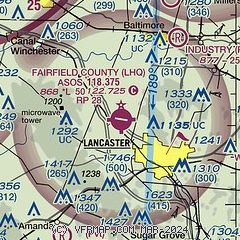
|
| Airport distance calculator |
|---|
|
|
| Sunrise and sunset |
|---|
|
Times for 26-Apr-2026
| | Local
(UTC-4) | | Zulu
(UTC) |
|---|
| Morning civil twilight | | 06:10 | | 10:10 |
| Sunrise | | 06:39 | | 10:39 |
| Sunset | | 20:18 | | 00:18 |
| Evening civil twilight | | 20:47 | | 00:47 |
|
| Current date and time |
|---|
| Zulu (UTC) | 26-Apr-2026 15:22:32 |
|---|
| Local (UTC-4) | 26-Apr-2026 11:22:32 |
|---|
|
| METAR |
|---|
| KLHQ | 261453Z AUTO 05009KT 10SM OVC013 10/07 A3010 RMK AO2 SLP193 T01000067 51007
|
KLCK
13nm W | 261455Z AUTO 08007KT 10SM OVC013 10/07 A3010 RMK AO2 T01030069
|
KVTA
18nm NE | 261454Z AUTO 07007KT 10SM OVC012 09/07 A3009 RMK AO2 SLP191 T00940067 51006
|
KCMH
18nm NW | 261451Z 05007KT 10SM OVC013 11/07 A3009 RMK AO2 SLP190 T01060067 51006
|
|
| TAF |
|---|
KLCK
13nm W | 261120Z 2612/2712 02009KT P6SM OVC015 FM261700 07009KT P6SM BKN018 FM262000 07009KT P6SM FEW025 FM270400 10006KT P6SM FEW250
|
KCMH
18nm NW | 261120Z 2612/2712 02009KT P6SM OVC015 FM261700 07009KT P6SM BKN018 FM262000 07009KT P6SM FEW025 FM270400 10006KT P6SM FEW250
|
|
| NOTAMs |
|---|
NOTAMs are issued by the DoD/FAA and will open in a separate window not controlled by AirNav.
|
|


