FAA INFORMATION EFFECTIVE 04 SEPTEMBER 2025
Location
| FAA Identifier: | LKV |
| Lat/Long: | 42-09-40.0000N 120-23-56.7000W
42-09.666667N 120-23.945000W
42.1611111,-120.3990833
(estimated) |
| Elevation: | 4734.1 ft. / 1443.0 m (surveyed) |
| Variation: | 14E (2015) |
| From city: | 3 miles SW of LAKEVIEW, OR |
| Time zone: | UTC -7 (UTC -8 during Standard Time) |
| Zip code: | 97630 |
Airport Operations
| Airport use: | Open to the public |
| Activation date: | 12/1943 |
| Control tower: | no |
| ARTCC: | SEATTLE CENTER |
| FSS: | MC MINNVILLE FLIGHT SERVICE STATION |
| NOTAMs facility: | LKV (NOTAM-D service available) |
| Attendance: | APR-SEP 0900-1600, OCT-MAR 0700-1700 |
| Wind indicator: | lighted, TETRAHEDRON LIGHTING INOPERATIVE. |
| Segmented circle: | yes |
| Lights: | ACTVT MIRL RWY 17/35, PAPI 17 & 35; REIL RWY 17 & 35 - CTAF. |
| Beacon: | white-green (lighted land airport)
Operates sunset to sunrise. |
Airport Communications
| CTAF/UNICOM: | 122.8 |
| WX AWOS-3PT: | 135.525 (541-947-5069) |
- APCH/DEP CTL SVC PRVDD BY SEATTLE ARTCC (ZSE) ON FREQS 127.6/346.35 (KLAMATH FALLS RCAG).
Nearby radio navigation aids
| VOR radial/distance | | VOR name | | Freq | | Var |
|---|
| LKVr147/20.5 | | LAKEVIEW VORTAC | | 112.00 | | 19E |
Airport Services
| Fuel available: | 100LL JET-A |
| Parking: | tiedowns |
| Airframe service: | MAJOR |
| Powerplant service: | MAJOR |
| Bottled oxygen: | NONE |
| Bulk oxygen: | NONE |
Runway Information
Runway 17/35
| Dimensions: | 5318 x 100 ft. / 1621 x 30 m |
| Surface: | asphalt, in good condition |
| Weight bearing capacity: | | Single wheel: | 74.0 | | Double wheel: | 86.0 |
|
| Runway edge lights: | medium intensity |
| RUNWAY 17 | | RUNWAY 35 |
| Latitude: | 42-10.103980N | | 42-09.228620N |
| Longitude: | 120-23.942055W | | 120-23.947240W |
| Elevation: | 4734.1 ft. | | 4725.1 ft. |
| Traffic pattern: | left | | left |
| Runway heading: | 166 magnetic, 180 true | | 346 magnetic, 000 true |
| Markings: | nonprecision, in good condition | | nonprecision, in good condition |
| Visual slope indicator: | 4-light PAPI on right (3.00 degrees glide path) | | 4-light PAPI on left (3.00 degrees glide path) |
| Runway end identifier lights: | yes | | yes |
| Touchdown point: | yes, no lights | | yes, no lights |
Airport Ownership and Management from official FAA records
| Ownership: | Publicly-owned |
| Owner: | LAKE COUNTY
LAKE COUNTY COURTHOUSE, 513 CENTER STREET
LAKEVIEW, OR 97630
Phone 541-947-6003 |
| Manager: | TRISTAN WITHAM
17819 AIRPORT ROAD
LAKE VIEW, OR 97630
Phone 541-947-4222 |
Additional Remarks
| - | FLOCKS OF LARGE WATERFOWL IN VICINITY NOV-MAY. |
| - | EXTENSIVE AIRTANKER OPNS IN FIRE SEASON. |
| - | DRAG STRIP ORIENTED NW-SE LOCATED 3000 FT SW OF RY 35. |
| - | POSSIBLE GLIDER OPERATIONS ON TWY. |
| - | TWY NE/SW USED FOR STRONG CROSS WIND LNDG. |
| - | WILDLIFE ON AND INVOF ARPT. |
| - | FOR CD IF UNA TO CTC ON FSS FREQ, CTC SEATTLE ARTCC AT 253-351-3694. |
| - | COLD TEMPERATURE AIRPORT. ALTITUDE CORRECTION REQUIRED AT OR BELOW -26C. |
Instrument Procedures
NOTE: All procedures below are presented as PDF files. If you need a reader for these files, you should download the free Adobe Reader.NOT FOR NAVIGATION. Please procure official charts for flight.
FAA instrument procedures published for use from 04 September 2025 at 0901Z to 02 October 2025 at 0900z.
IAPs - Instrument Approach Procedures |
|---|
| RNAV (GPS) RWY 17 | |
download (296KB) |
| RNAV (GPS) RWY 35 | |
download (300KB) |
| NOTE: Special Alternate Minimums apply | |
download (177KB) |
| NOTE: Special Take-Off Minimums/Departure Procedures apply | |
download (541KB) |
Other nearby airports with instrument procedures:
KAAT - Alturas Municipal Airport (41 nm S)
KLMT - Crater Lake/Klamath Regional Airport (59 nm W)
62S - Christmas Valley Airport (66 nm N)
KSIY - Siskiyou County Airport (95 nm W)
|
|

Road maps at:
MapQuest
Bing
Google
| Aerial photo |
|---|
WARNING: Photo may not be current or correct
 Taken in April 2007
from 7,500 feet
Taken in April 2007
from 7,500 feet
Do you have a better or more recent aerial photo of Lake County Airport that you would like to share? If so, please send us your photo.
|
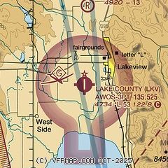
| Sectional chart |
|---|
|
| Airport distance calculator |
|---|
|
|
| Sunrise and sunset |
|---|
|
Times for 25-Sep-2025
| | Local
(UTC-7) | | Zulu
(UTC) |
|---|
| Morning civil twilight | | 06:25 | | 13:25 |
| Sunrise | | 06:53 | | 13:53 |
| Sunset | | 18:53 | | 01:53 |
| Evening civil twilight | | 19:21 | | 02:21 |
|
| Current date and time |
|---|
| Zulu (UTC) | 25-Sep-2025 17:22:45 |
|---|
| Local (UTC-7) | 25-Sep-2025 10:22:45 |
|---|
|
| METAR |
|---|
| KLKV | 251653Z AUTO 00000KT 10SM CLR 18/M01 A3017 RMK AO2 SLP193 T01781011
|
|
| NOTAMs |
|---|
NOTAMs are issued by the DoD/FAA and will open in a separate window not controlled by AirNav.
|
|


