FAA INFORMATION EFFECTIVE 09 JULY 2026
Location
| FAA Identifier: | LOL |
| Lat/Long: | 40-03-59.2829N 118-33-54.3100W
40-03.988048N 118-33.905167W
40.0664675,-118.5650861
(estimated) |
| Elevation: | 3907.6 ft. / 1191.0 m (surveyed) |
| Variation: | 14E (2010) |
| From city: | 8 miles SW of LOVELOCK, NV |
| Time zone: | UTC -7 (UTC -8 during Standard Time) |
| Zip code: | 89419 |
Airport Operations
| Airport use: | Open to the public |
| Activation date: | 10/1943 |
| Control tower: | no |
| ARTCC: | OAKLAND CENTER |
| FSS: | RENO FLIGHT SERVICE STATION |
| NOTAMs facility: | LOL (NOTAM-D service available) |
| Attendance: | UNATNDD |
| Pattern altitude: | 4707.6 ft. MSL |
| Wind indicator: | yes |
| Segmented circle: | yes |
| Lights: | ACTVT REIL RWY 02 & 20, MIRL RWY 02/20 - CTAF. |
| Beacon: | white-green (lighted land airport)
Operates sunset to sunrise. |
Airport Communications
| CTAF/UNICOM: | 122.8 |
| WX ASOS: | 120.675 (775-273-0427) |
- APCH/DEP CTL SVC PRVDD BY OAKLAND ARTCC (ZOA) ON FREQS 128.8/285.5 (FALLON RCAG).
- COMMUNICATIONS PRVDD BY RENO RADIO ON FREQ 122.4 (LOVELOCK RCO).
Nearby radio navigation aids
| VOR radial/distance | | VOR name | | Freq | | Var |
|---|
| LLCr155/3.6 | | LOVELOCK VORTAC | | 116.50 | | 16E |
| HZNr014/38.6 | | HAZEN VORTAC | | 114.10 | | 17E |
Airport Services
| Fuel available: | 100LL
100LL:24 HR SELF-SERVICE |
| Parking: | tiedowns |
| Bottled oxygen: | NONE |
| Bulk oxygen: | NONE |
Runway Information
Runway 2/20
| Dimensions: | 5529 x 75 ft. / 1685 x 23 m |
| Surface: | asphalt, in good condition |
| Weight bearing capacity: | |
| Runway edge lights: | medium intensity |
| Operational restrictions: | NO LINE OF SIGHT BTN RWYS. |
| RUNWAY 2 | | RUNWAY 20 |
| Latitude: | 40-03.714972N | | 40-04.500020N |
| Longitude: | 118-34.370678W | | 118-33.770543W |
| Elevation: | 3903.1 ft. | | 3907.2 ft. |
| Traffic pattern: | left | | left |
| Runway heading: | 016 magnetic, 030 true | | 196 magnetic, 210 true |
| Markings: | nonprecision, in good condition | | nonprecision, in poor condition |
| Visual slope indicator: | 2-light PAPI on left (3.00 degrees glide path) | | 2-light PAPI on left (3.00 degrees glide path) |
| Runway end identifier lights: | yes | | yes |
| Touchdown point: | yes, no lights | | yes, no lights |
| Obstructions: | none | | 4 ft. fence, 300 ft. from runway, 25:1 slope to clear |
Runway 8/26
| Dimensions: | 4931 x 75 ft. / 1503 x 23 m |
| Surface: | asphalt, in good condition |
| Weight bearing capacity: | |
| RUNWAY 8 | | RUNWAY 26 |
| Latitude: | 40-03.857038N | | 40-03.851195N |
| Longitude: | 118-34.248107W | | 118-33.191208W |
| Elevation: | 3903.3 ft. | | 3902.8 ft. |
| Traffic pattern: | left | | left |
| Runway heading: | 076 magnetic, 090 true | | 256 magnetic, 270 true |
| Displaced threshold: | no | | 120 ft. |
| Markings: | basic, in good condition | | basic, in fair condition |
| Touchdown point: | yes, no lights | | yes, no lights |
| Obstructions: | none
3 FT BERM 175 FT FM EOR. | | 5 ft. fence, 250 ft. from runway, 10:1 slope to clear |
Airport Ownership and Management from official FAA records
| Ownership: | Publicly-owned |
| Owner: | PERSHING COUNTY
COUNTY CLERKS OFFICE, PO BOX 820
LOVELOCK, NV 89419
Phone 775-273-2208 |
| Manager: | CHUCK SAYLES
P. O. BOX DRAWER E
LOVELOCK, NV 89419
Phone 775-304-2010 |
Additional Remarks
Instrument Procedures
NOTE: All procedures below are presented as PDF files. If you need a reader for these files, you should download the free Adobe Reader.NOT FOR NAVIGATION. Please procure official charts for flight.
FAA instrument procedures published for use from 09 July 2026 at 0901Z to 06 August 2026 at 0900Z.
IAPs - Instrument Approach Procedures |
|---|
| RNAV (GPS) RWY 02 | |
download (258KB) |
| RNAV (GPS) RWY 20 | |
download (317KB) |
| VOR-A | |
download (270KB) |
| NOTE: Special Alternate Minimums apply | |
download (119KB) |
| NOTE: Special Take-Off Minimums/Departure Procedures apply | |
download (349KB) |
Other nearby airports with instrument procedures:
KFLX - Fallon Municipal Airport (35 nm S)
KNFL - Fallon Naval Air Station (Van Voorhis Field) Airport (39 nm S)
KSPZ - Silver Springs Airport (51 nm SW)
KWMC - Winnemucca Municipal Airport (61 nm NE)
KRTS - Reno/Stead Airport (65 nm W)
|
|

Road maps at:
MapQuest
Bing
Google
| Aerial photo |
|---|
WARNING: Photo may not be current or correct

Do you have a better or more recent aerial photo of Derby Field Airport that you would like to share? If so, please send us your photo.
|
| Sectional chart |
|---|
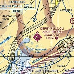
|
CAUTION: Diagram may not be current

| Airport distance calculator |
|---|
|
|
| Sunrise and sunset |
|---|
|
Times for 26-Jul-2026
| | Local
(UTC-7) | | Zulu
(UTC) |
|---|
| Morning civil twilight | | 05:17 | | 12:17 |
| Sunrise | | 05:48 | | 12:48 |
| Sunset | | 20:13 | | 03:13 |
| Evening civil twilight | | 20:44 | | 03:44 |
|
| Current date and time |
|---|
| Zulu (UTC) | 26-Jul-2026 18:08:26 |
|---|
| Local (UTC-7) | 26-Jul-2026 11:08:26 |
|---|
|
| METAR |
|---|
| KLOL | 261753Z AUTO 00000KT 10SM CLR 30/M09 A3010 RMK AO2 SLP141 T03001089 10306 20156 58004
|
|
| NOTAMs |
|---|
NOTAMs are issued by the DoD/FAA and will open in a separate window not controlled by AirNav.
|
|


