FAA INFORMATION EFFECTIVE 09 JULY 2026
Location
| FAA Identifier: | LSV |
| Lat/Long: | 36-14-10.3200N 115-02-03.3200W
36-14.172000N 115-02.055333W
36.2362000,-115.0342556
(estimated) |
| Elevation: | 1869.1 ft. / 570 m (estimated) |
| Variation: | 12E (2015) |
| From city: | 7 miles NE of LAS VEGAS, NV |
| Time zone: | UTC -7 (UTC -8 during Standard Time) |
| Zip code: | 89156 |
Airport Operations
| Airport use: | Private use. Permission required prior to landing |
| Activation date: | 11/1937 |
| Control tower: | yes |
| ARTCC: | LOS ANGELES CENTER |
| FSS: | RENO FLIGHT SERVICE STATION |
| NOTAMs facility: | LSV (NOTAM-D service available) |
| Attendance: | CONTINUOUS |
| Pattern altitude: | RECT TFC PAT 3000 FT; OVERHEAD TFC PAT 3500 FT. |
| Wind indicator: | yes |
| Segmented circle: | no |
| Lights: | RWY 03R & 21L ALSF-1 APCH LGTS NTE STEP 3 INTST. |
| Beacon: | white-green (lighted land airport)
Operates sunset to sunrise. |
Airport Communications
| ATIS: | 270.1 |
| NELLIS GROUND: | 121.8 275.8 |
| NELLIS TOWER: | 132.55 327.0 |
| NELLIS APPROACH: | 118.125 291.725 |
| NELLIS DEPARTURE: | 135.1 350.225 |
| CLEARANCE DELIVERY: | 120.9 289.4 |
| CLASS B: | 124.95 ;NORTH 273.55 ;NORTH |
| COMD POST: | 320.0 ;ACC HAVE QUICK TIMING AVBL 381.3 ;ACC RAYMOND 22 |
| EMERG: | 121.5 243.0 |
| OPS: | 340.2 ;AF OPS |
| PMSV METRO: | 323.9 344.6 |
| PTD: | 139.3 372.2 |
| SFA: | 321.1 326.2 385.5 397.2 |
| SOF: | 305.6 ;CALL BULLSEYE SOF |
| WX ASOS at VGT (8 nm W): | 118.05 (702-648-6633) |
| WX ASOS at LAS (11 nm SW): | PHONE 702-582-5334 |
| WX AWOS-3PT at HND (17 nm S): | 120.775 (702-614-4537) |
| WX AWOS-3 at BVU (19 nm SE): | 118.475 (702-293-1532) |
- MAC ALCE /NELLIS ALCE/ OPNS OPER 24 HRS.
- FREQ 323.9 PMSV UNREL 085DEG-155DEG BYD 35 NM AT OR BLW FL 200, 315DEG-005DEG BYD 40 NM AT OR BLW FL 200, 230DEG-290DEG BYD 55 NM AT OR BLW FL 200.
- FREQS 139.3 & 372.2 UNREL 085DEG-155DEG BYD 35 NM AT FL 200, 315DEG-005DEG BYD 40 NM AT FL 200, 230DEG-290DEG BYD 55 NM AT FL 200.
- NELLIS CONTROL, NV KLSV (R) FOR VFR/IFR SVC IN R4806E, R4806W, R4807A, R4807B, R4808N, R4808S, R4809 THE DESERT MOA AND THE OVERLYING ATCAAS, CTC NELLIS CONTROL ON THE APPROPRIATE FREQ. WILSON CREEK - 126.65 317.525; TONOPAH -119.35 254.4; LAS VEGAS - 126.65 317.525; CALIENTE - 126.65 317.525; MORMON MESA - 126.65 317.525 H-2B, L-5B; TONOPAH TEST RANGE 119.35 254.4.
- ALCE AMC - OPR ONLY DUR RED FLAG DEPLOYMENT/CHG OVER/REDEPLOYMENT AND OTHER EXER. 257.35 259.95.
- SFA
- FREQ 120.9 & 289.4 CD OPR 1400-0600Z++, FULL SVS AVBL DUR NELLIS FLYING.
- ILS/RADAR: TOLICHA PEAK RADAR - NO-NOTAM MP: ASR FIRST FULL WEEK OF EVERY MONTH.
- PMSV METRO: FULL SVC AVBL DURG WX OPS HRS; PMSV UNREL 085-155 DEG BYD 35 NM AT OR BLW FL 200, 315-005 DEG BYD 40 NM AT OR BLW FL 200, 230-290 DEG BYD 55 NM AT OR BLW FL 200.
Nearby radio navigation aids
| VOR radial/distance | | VOR name | | Freq | | Var |
|---|
| LASr018/11.2 | | LAS VEGAS VORTAC | | 116.90 | | 15E |
| BLDr315/16.6 | | BOULDER CITY VORTAC | | 116.70 | | 15E |
Airport Services
| Fuel available: | A++ |
| Parking: | hangars |
| Airframe service: | MAJOR |
| Powerplant service: | MAJOR |
| Bottled oxygen: | NONE |
| Bulk oxygen: | HIGH/LOW |
Runway Information
Runway 3L/21R
| Dimensions: | 10120 x 200 ft. / 3085 x 61 m
FIRST 1320 FT RWY 21R & 920 FT RWY 03L GROOVED CONCRETE; MID 7879 FT CNTR 80 FT CONC RMNG ASPH. |
| Surface: | concrete, in good condition |
| Weight bearing capacity: | |
| Runway edge lights: | high intensity |
| RUNWAY 3L | | RUNWAY 21R |
| Latitude: | 36-13.601667N | | 36-14.854833N |
| Longitude: | 115-02.808167W | | 115-01.450000W |
| Elevation: | 1833.6 ft. | | 1869.1 ft. |
| Traffic pattern: | right | | right |
| Runway heading: | 029 magnetic, 041 true | | 209 magnetic, 221 true |
| Markings: | precision, in good condition | | precision, in good condition |
| Visual slope indicator: | 4-light PAPI on left (3.00 degrees glide path)
RWY 03R - 03L PAPI LED. RWY 21R - 21L PAPI INCANDESCENT. | | 4-light PAPI on left (3.00 degrees glide path) |
| Runway end identifier lights: | no | | no |
| Touchdown point: | yes, no lights | | yes, no lights |
Runway 3R/21L
| Dimensions: | 10051 x 150 ft. / 3064 x 46 m |
| Surface: | concrete, in good condition |
| Weight bearing capacity: | |
| Runway edge lights: | high intensity |
| Operational restrictions: | STEEP RISING TRRN S & E OF CNTRLN; RWY 03R/21L PROVDS BTR BA THAN RWY 03L/21R WHEN WET; RWY 03R/21L UNGROOVED; USE CTN FOR HYDROPLANING. |
| RUNWAY 3R | | RUNWAY 21L |
| Latitude: | 36-13.493000N | | 36-14.737667N |
| Longitude: | 115-02.655333W | | 115-01.306333W |
| Elevation: | 1825.9 ft. | | 1865.1 ft. |
| Traffic pattern: | right | | right |
| Runway heading: | 029 magnetic, 041 true | | 209 magnetic, 221 true |
| Markings: | precision, in good condition | | precision, in good condition |
| Visual slope indicator: | 4-light PAPI on left (3.00 degrees glide path) | | 4-light PAPI on left (3.00 degrees glide path) |
| RVR equipment: | touchdown | | rollout |
| Approach lights: | ALSF1: standard 2,400 foot high intensity approach lighting system with centerline sequenced flashers (category I) | | ALSF1: standard 2,400 foot high intensity approach lighting system with centerline sequenced flashers (category I) |
| Runway end identifier lights: | no | | no |
| Touchdown point: | yes, no lights | | yes, no lights |
| Instrument approach: | | | LOC/GS |
Helipad H1
| Dimensions: | 100 x 100 ft. / 30 x 30 m |
| Surface: | concrete, in good condition |
| Latitude: | 36-15.084667N | | |
| Longitude: | 115-01.631333W | | |
| Elevation: | 1882.4 ft. | | |
| Traffic pattern: | left | | left |
| Markings: | NSTD, in good condition | | |
Airport Ownership and Management from official FAA records
| Ownership: | U.S. Air Force |
| Owner: | USAF
NELLIS AFB
LAS VEGAS, NV 89110 |
| Manager: | CHIEF OF AFLD MANAGEMENT
NELLIS AFB
LAS VEGAS, NV 89110
Phone 702-652-4359 |
Additional Remarks
| A30A-21L | 9000-10000 DIST RMNG MKR E SIDE NA. |
| E60-03R | HOOK BAK-12B(B)(41' OVRN) HOOK BAK-14 HOOK BAK-12B(B)(1226'). |
| E60-03L | HOOK BAK-12B(B)(41'OVRN) HOOK BAK-12B(B)(1211'). |
| E60-21R | HOOK BAK-12B(B)(1451') HOOK BAK-12B(B)(41' OVRN). |
| E60-21L | HOOK BAK-14 HOOK BAK-12B(B)(1200') HOOK BAK-12B(B)(46' OVRN). |
| - | SERVICE- LGT: RWY THR LGTS GATED. |
| - | JASU: NO STARTER UNIT OR CAPABILITY FOR F4B, F4J; NO STARTER PROBE FOR USN ACFT; 2(MA-1A). |
| - | FLUID: W-EXP 2-3 HR DELAY; SP PRESAIR LHOX LOX. |
| - | OIL: O-123-128-132-133-148-156 SOAP. |
| - | RSTD: BIRD WATCH COND MOD; OPS RSTD; TKOF OR LDG PMSN ONLY WHEN DEP & ARR AVOID BIRD ACT; LCL IFR/VFR TFC PAT NA. BIRD WATCH COND SVR; TKOF OR LDG NA WO OG/CC APVL. |
| - | CTN: STEEPLY RISING TRRN COMMENCING 2.7 NM EAST OF RWY 03R-21L CNTRLN UP TO 3359 MSL. HIGH POTENTIAL FOR HYDROPLANING ON BOTH RWYS DUR WET CONDS. ACFT TAXG ON TWY D BTN TWY F AND RWY 21R USE CTN, 4 FT 8 INCH HI DSTC RMNG SIGN LCTD 125 FT NORTH OF TWY D CNTRLN. HVY ACFT ENG RUNS PMTD ON RWY; REQ MUST BE SKED THRU AIRFIELD MGMT OPS DSN 68204600. DUE TO FOD PROBLEM, 4 ENG ACFT WILL TAXI WITH OUTBOARD ENGS AT IDLE PWR OR SHTDN IF PSBL. JOLLY AND TSNT HELIPADS MISG MANDATORY HOLD POS SIGNS. RWY CONDS NOT RPRTD. |
| - | TFC PAT: DEP CLIMB ABV 3000 FT NA UNTIL DER. |
| - | RSTD: SUN & HOL EXP ARR FM N; DEP FM N WINDS PERM; TFC PAT TWDS E. |
| - | MISC: NO CLASSIFIED MTRL STORAGE AVBL AT AM OPS; CLASSIFIED MUST BE STORED IN NELLIS AFB COMMAND POST. TSNT ACFT SHALL COMMUNICATE WITH NELLIS ATC ON UHF TO MAX EXTENT PSBL DUE TO HVY CONCENTRATION OF ACFT IN THE VFR PAT. RSRS WILL BE APPLIED TO BASE ASGND/DEPLOYED ACFT. |
| - | MISC: WX OBS VIEW OF AER 03R/L RSTD 190-330 DEG BY FLIGHTLINE BLDGS & FAC & AT NGT DUE TO RAMP LGT. |
| - | MISC: WX SUPPORT H24 - DSN 682-4744, C702-652-4744; MSN SUPPORT WX PER WING & EXER SKED TYPICALLY 1300++ MON THRU 0530++ FRI CLSD WKND & HOL; TSNT WX AFT HR VIA DAVIS MONTHAN 25OWS - D228-6598/6599, C520-228-6598/6599. |
| - | HOT CARGO PAD UNLIT; RSTD TO DAYLIGHT/VFR OPS. |
| - | A-GEAR: ALL BAK-12B EXTN & IN RAISED POSN, RQR 30 MIN PN FOR REMOVAL. |
| - | SVC-TSNT ALERT: AVBL MON-FRI 1600Z-0400Z++, NO QUICK TURN FRI-SUN. NO MIL FLEET SVC AVBL. LTD TSNT SVC AVBL. TSNT ALERT CONTRACT BACKSHOP MAINT SUPPORT MAY RQR REIMBURSEMENT AND COORD WITH CONTRACT OFFICER. DUE TO LARGE NR OF TSNT AND EXER ACFT EXP DELAYS WITH TRAN ALERT. |
| - | RSTD: FORWARD FIRING MUNITIONS IN REVETMENTS 12, 13 & 25 NA. |
| - | CTN: INCREASED DURG BASH PHASE II APR-MAY & AUG-OCT. |
| - | SERVICE-A-GEAR: RWY 03R-21L BAK-14 OPS: BOTH BAK-14 APCH END AND DEP END WILL BE IN LOWERED POS. AVBL UPON REQ FOR EMER USE ONLY. SLOW TO 20 KTS OR LESS PRIOR TO DEP END CABLE & TAXI TO FAR EDGE OF COLD SIDE OF RWY; TAXI BTN RWY EDGE & OUTERMOST BAK-14 BUMPER. |
| - | CTN: TWY A EAST TACAN CK POINT SIGN NSTD. |
| - | SERVICE-LGT: TWY EDGE LGTS ADJ TO MAIN APN PRKG ROWS 1 & 2 MISG. |
| - | RSTD: ALL TSNT ACFT MUST OBTAIN PPR PRIOR TO ARR. REFER TO NELLIS NOTAMS TO ID AVBL AIRFIELD SVCS WINDOW. PPR MAY BE ISSUED UP TO 7 DAYS PRIOR TO, BUT NLT 48 HRS PRIOR TO SKED ARR. PPR FOR ALL ACFT; CTC AM OPS DSN 682-4601, C702-652-4601. RON REQ GOOD FOR ONE NGT ONLY, DEPENDENT UPON RAMP SPACE. TRAN FTR, NON EXER ACFT, PRKG LMTD TO ROWS 45-46. ACFT MUST ADHERE TO PPR ARR BLOCK +/- 30 MINS OF SKED LDG. MULT APCH NA DURG RF/LFE OR AFT OFFL SS UNLESS APVD BY 57 WG SOF. ACFT PTCPG IN NELLIS SPONSORED EXERS/LARGE FORCE EXERS RQR LCL SPONSORING UNIT. THE LCL SPONSORING UNIT WILL COORD MAINT, PRKG, AND SVCS. PL-2 ACFT MUST BRING OWN SCTY PSNL AND DETAIL FOR ALL LARGE FORCE EXERS. FOR CSTMS AND AG, CTC NELLIS SUPPORT CNTR FOR ACFT WITH WIGNSPANS OF 132.6 FT OR LRGR AT DSN 682-5250 OR CTC BASE OPS FOR ALL OTHER ACFT AT DSN 682-4601 WITH 24 HR PN. SUN AND HOL TFC EXPC ARR FM NORTH, DEP ACFT NORTH WINDS PMTD WITH TFC PAT TWD EAST (SUNRISE MT). PROGRESSIVE TAXI AVBL. ACFT WITH DV CODE 7 OR HYR CTC PTD WHEN 100 NM OUT. ALL INBD PAX/CARGO AND DV ACFT MUST CTC COMMAND POST (GAMBLER 99) ON 381.300 NLT 30 MINS PRIOR TO LDG. B-52 OPS LTD TO 380K LB. |
| - | COMMUNICATIONS-SOF: REMARKS: (CALL BULLSEYE SOF); LCL EMERG FREQ 343.725. |
Instrument Procedures
NOTE: All procedures below are presented as PDF files. If you need a reader for these files, you should download the free Adobe Reader.NOT FOR NAVIGATION. Please procure official charts for flight.
FAA instrument procedures published for use from 09 July 2026 at 0901Z to 06 August 2026 at 0900Z.
IAPs - Instrument Approach Procedures |
|---|
| HI-ILS OR LOC Z RWY 21L | |
download (147KB) |
| ILS OR LOC X RWY 21L | |
download (130KB) |
| LOC Y RWY 21L | |
download (290KB) |
| HI-TACAN RWY 03R | |
download (147KB) |
| HI-TACAN Y RWY 21L | |
download (464KB) |
| HI-TACAN Z RWY 21L | |
download (465KB) |
| TACAN X RWY 21L | |
download (140KB) |
| SIN CITY VISUAL RWY 03L/R | |
download (145KB) |
Departure Procedures |
|---|
| DREAM SEVEN | |
download (131KB) |
| FYTTR SEVEN | |
download (107KB) |
| MORMON MESA EIGHT | |
download (124KB) |
| NOTE: Special Take-Off Minimums/Departure Procedures apply | |
download (390KB) |
Other nearby airports with instrument procedures:
KVGT - North Las Vegas Airport (8 nm W)
KLAS - Harry Reid International Airport (11 nm SW)
KHND - Henderson Executive Airport (17 nm S)
KBVU - Boulder City Municipal Airport (19 nm SE)
67L - Mesquite Airport (59 nm NE)
|
|

Road maps at:
MapQuest
Bing
Google
| Aerial photo |
|---|
WARNING: Photo may not be current or correct

Do you have a better or more recent aerial photo of Nellis Air Force Base that you would like to share? If so, please send us your photo.
|
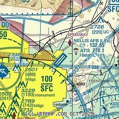
| Sectional chart |
|---|
|
 Download PDF
of official airport diagram from the FAA
| Airport distance calculator |
|---|
|
|
| Sunrise and sunset |
|---|
|
Times for 27-Jul-2026
| | Local
(UTC-7) | | Zulu
(UTC) |
|---|
| Morning civil twilight | | 05:15 | | 12:15 |
| Sunrise | | 05:44 | | 12:44 |
| Sunset | | 19:49 | | 02:49 |
| Evening civil twilight | | 20:18 | | 03:18 |
|
| Current date and time |
|---|
| Zulu (UTC) | 28-Jul-2026 04:41:41 |
|---|
| Local (UTC-7) | 27-Jul-2026 21:41:41 |
|---|
|
| METAR |
|---|
| KLSV | 280355Z 21007KT 10SM CLR 39/M05 A2971 RMK AO2A SLP026 T03901051 $
|
KVGT
8nm W | 280353Z 20009KT 10SM CLR 39/00 A2978 RMK AO2 SLP065 T03890000
|
KLAS
11nm SW | 280356Z 22010KT 10SM CLR 39/01 A2980 RMK AO2 SLP057 T03890011 $
|
KHND
16nm S | 280356Z AUTO 23009KT 10SM CLR 37/02 A2985 RMK AO2 SLP084 T03720022 $
|
KBVU
19nm SE | 280415Z AUTO 00000KT 10SM CLR 37/M02 A2979 RMK AO2
|
|
| TAF |
|---|
| KLSV | 272300Z 2723/2905 22015G25KT 9999 FEW200 520009 QNH2975INS BECMG 2802/2803 24010G15KT 9999 FEW200 QNH2975INS BECMG 2806/2807 18009KT 9999 FEW200 QNH2981INS BECMG 2818/2819 20010G20KT 9999 FEW150 FEW200 510009 QNH2982INS TX44/2723Z TN23/2812Z
|
KVGT
8nm W | 271727Z 2718/2818 14007KT P6SM FEW120 SCT200 FM271900 19012G20KT P6SM FEW120 SCT200 FM280300 23008KT P6SM FEW200 FM281000 VRB06KT P6SM FEW200
|
KLAS
11nm SW | 280253Z 2803/2906 21009KT P6SM FEW200 FM281500 14004KT P6SM FEW200 FM281800 21009G18KT P6SM FEW200 FM290400 23007KT P6SM FEW200
|
KHND
16nm S | 271727Z 2718/2818 21012G20KT P6SM FEW120 SCT200 FM280400 20009KT P6SM FEW200
|
|
| NOTAMs |
|---|
NOTAMs are issued by the DoD/FAA and will open in a separate window not controlled by AirNav.
|
|


