FAA INFORMATION EFFECTIVE 16 APRIL 2026
Location
| FAA Identifier: | MAL |
| Lat/Long: | 44-51-13.2000N 074-19-44.2000W
44-51.220000N 074-19.736667W
44.8536667,-74.3289444
(estimated) |
| Elevation: | 789.9 ft. / 240.8 m (surveyed) |
| Variation: | 15W (2000) |
| From city: | 2 miles W of MALONE, NY |
| Time zone: | UTC -4 (UTC -5 during Standard Time) |
| Zip code: | 12953 |
Airport Operations
| Airport use: | Open to the public |
| Activation date: | 11/1942 |
| Control tower: | no |
| ARTCC: | BOSTON CENTER |
| FSS: | BURLINGTON FLIGHT SERVICE STATION |
| NOTAMs facility: | BTV (NOTAM-D service available) |
| Attendance: | |
| Wind indicator: | lighted |
| Segmented circle: | yes |
| Lights: | ACTVT PAPI RWY 05 & 23, MIRL RWY 05/23, 14/32 & TWY LGTS - CTAF. |
| Beacon: | white-green (lighted land airport)
Operates sunset to sunrise. |
Airport Communications
| CTAF/UNICOM: | 122.8 |
| WX AWOS-AV: | 122.8 ((518) 651-2601) |
- APCH/DEP SVC PRVDD BY BOSTON ARTCC ON FREQS 135.25/377.1 (TURIN RCAG).
Nearby radio navigation aids
| NDB name | | Hdg/Dist | | Freq | | Var | | ID |
|---|
| POTSDAM | | 086/24.8 | | 400 | | 14W | | PTD | .--. - -.. |
Airport Services
| Fuel available: | 100LL |
| Parking: | tiedowns |
| Airframe service: | NONE |
| Powerplant service: | NONE |
| Bottled oxygen: | NONE |
| Bulk oxygen: | NONE |
Runway Information
Runway 5/23
| Dimensions: | 3994 x 100 ft. / 1217 x 30 m |
| Surface: | asphalt, in excellent condition |
| Weight bearing capacity: | |
| Runway edge lights: | medium intensity |
| RUNWAY 5 | | RUNWAY 23 |
| Latitude: | 44-50.968522N | | 44-51.494252N |
| Longitude: | 074-20.177795W | | 074-19.623108W |
| Elevation: | 770.7 ft. | | 754.4 ft. |
| Traffic pattern: | left | | left |
| Runway heading: | 052 magnetic, 037 true | | 232 magnetic, 217 true |
| Declared distances: | TORA:3994 TODA:3994 ASDA:3994 LDA:3994 | | TORA:3994 TODA:3994 ASDA:3994 LDA:3994 |
| Markings: | nonprecision, in good condition | | nonprecision, in good condition |
| Visual slope indicator: | 2-light PAPI on left (3.15 degrees glide path) | | 2-light PAPI on left (3.00 degrees glide path) |
| Runway end identifier lights: | yes | | yes |
| Touchdown point: | yes, no lights | | yes, no lights |
| Obstructions: | 36 ft. trees, 392 ft. from runway, 255 ft. left of centerline, 5:1 slope to clear | | 20 ft. trees, 671 ft. from runway, 285 ft. right of centerline, 23:1 slope to clear |
Runway 14/32
| Dimensions: | 3250 x 75 ft. / 991 x 23 m |
| Surface: | asphalt, in good condition |
| Weight bearing capacity: | |
| Runway edge lights: | medium intensity |
| RUNWAY 14 | | RUNWAY 32 |
| Latitude: | 44-51.365080N | | 44-51.044040N |
| Longitude: | 074-19.836650W | | 074-19.235435W |
| Elevation: | 759.5 ft. | | 789.9 ft. |
| Traffic pattern: | left | | left |
| Runway heading: | 142 magnetic, 127 true | | 322 magnetic, 307 true |
| Displaced threshold: | no | | 348 ft. |
| Declared distances: | TORA:3250 TODA:3250 ASDA:3250 LDA:3250 | | TORA:3250 TODA:3250 ASDA:3250 LDA:2902 |
| Markings: | basic, in good condition | | basic, in fair condition |
| Touchdown point: | yes, no lights | | yes, no lights |
| Obstructions: | 30 ft. trees, 815 ft. from runway, 144 ft. left of centerline, 20:1 slope to clear
+5 FT CROPS 67 FT FROM THLD, 107 FT RIGHT. | | 18 ft. tree, 200 ft. from runway, 81 ft. right of centerline
+18 FT ROAD WITH TALL FARM EQUIPMENT, 27 FT FM RWY, ACROSS CNTRLN. |
Airport Ownership and Management from official FAA records
| Ownership: | Publicly-owned |
| Owner: | TOWN OF MALONE
27 AIRPORT ROAD
MALONE, NY 12953
Phone (518) 483-4740 |
| Manager: | BRUCE BURDITT
27 AIRPORT ROAD
MALONE, NY 12953
Phone (518) 483-4740 |
Additional Remarks
| - | HAYING ACTIVITY & EQUIPMENT PRESENT JUN - SEP. |
| - | RY 14/32 HAS SNOW REMOVAL BUT VISUAL INSPECTION & NOTAM CHECK MUST BE DONE AS TOWN ROADS ARE PLOWED BEFORE ARPT. |
| - | FOR CD CTC BOSTON ARTCC AT 603-879-6859. |
| - | AIRPORT NOT ATTENDED |
Instrument Procedures
NOTE: All procedures below are presented as PDF files. If you need a reader for these files, you should download the free Adobe Reader.NOT FOR NAVIGATION. Please procure official charts for flight.
FAA instrument procedures published for use from 16 April 2026 at 0901Z to 14 May 2026 at 0900Z.
IAPs - Instrument Approach Procedures |
|---|
| RNAV (GPS) RWY 05 | |
download (255KB) |
| RNAV (GPS) RWY 23 | |
download (245KB) |
| NOTE: Special Take-Off Minimums/Departure Procedures apply | |
download (150KB) |
Other nearby airports with instrument procedures:
KMSS - Massena International Airport-Richards Field (22 nm W)
KPTD - Potsdam Municipal Airport/Damon Field (28 nm W)
KSLK - Adirondack Regional Airport (29 nm S)
KPBG - Plattsburgh International Airport (39 nm E)
KLKP - Lake Placid Airport (39 nm SE)
|
|

Road maps at:
MapQuest
Bing
Google
| Aerial photo |
|---|
WARNING: Photo may not be current or correct
 Photo by Aroosh Naqvi
Do you have a better or more recent aerial photo of Malone-Dufort Airport that you would like to share? If so, please send us your photo.
|
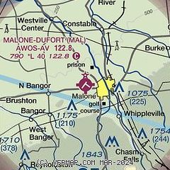
| Sectional chart |
|---|
|
| Airport distance calculator |
|---|
|
|
| Sunrise and sunset |
|---|
|
Times for 19-Apr-2026
| | Local
(UTC-4) | | Zulu
(UTC) |
|---|
| Morning civil twilight | | 05:36 | | 09:36 |
| Sunrise | | 06:07 | | 10:07 |
| Sunset | | 19:46 | | 23:46 |
| Evening civil twilight | | 20:17 | | 00:17 |
|
| Current date and time |
|---|
| Zulu (UTC) | 19-Apr-2026 15:56:01 |
|---|
| Local (UTC-4) | 19-Apr-2026 11:56:01 |
|---|
|
| METAR |
|---|
CWBZ
16nm N | 191500Z AUTO 24010G15KT 02/00 RMK AO1 2PAST HR 1016 SLP129 P0001 T00170000 50004
|
KMSS
23nm W | 191536Z AUTO 21009KT 10SM BKN010 02/00 A2993 RMK AO2 T00220000
|
KSLK
28nm S | 191541Z AUTO VRB05KT 7SM -SN SCT012 SCT019 OVC065 M01/M03 A2986 RMK AO2 P0000 T10061028
|
KPTD
28nm W | 191535Z AUTO 23008KT 10SM OVC017 02/01 A2993 RMK AO2 PNO
|
|
| TAF |
|---|
KMSS
23nm W | 191308Z 1913/2012 27010KT 2SM -SN BR SCT015 OVC025 FM191400 27011G20KT 3SM -SN BR OVC015 TEMPO 1914/1915 2SM -SN BR FM191500 25010KT P6SM BKN040 PROB30 1916/1919 4SM -SHSN BR FM191900 27011KT P6SM SCT040 FM200100 25009KT P6SM SCT080
|
KSLK
28nm S | 191132Z 1912/2012 25007KT P6SM -SHRA BKN012 OVC019 TEMPO 1912/1913 1 1/2SM -SN BKN008 FM191300 28007KT 1SM -SN BR OVC006 FM191700 28008G15KT 2SM -SHSN BR BKN014 FM191800 28008G15KT 4SM -SHSN BKN027 FM191900 28008G17KT 6SM BR SCT035 PROB30 1920/1924 4SM -SHRASN BR FM200300 25006KT P6SM SCT190
|
|
| NOTAMs |
|---|
NOTAMs are issued by the DoD/FAA and will open in a separate window not controlled by AirNav.
|
|

