FAA INFORMATION EFFECTIVE 25 DECEMBER 2025
Location
| FAA Identifier: | MCE |
| Lat/Long: | 37-17-05.1000N 120-30-50.1000W
37-17.085000N 120-30.835000W
37.2847500,-120.5139167
(estimated) |
| Elevation: | 155.2 ft. / 47.3 m (surveyed) |
| Variation: | 15E (2000) |
| From city: | 2 miles SW of MERCED, CA |
| Time zone: | UTC -8 (UTC -7 during Daylight Saving Time) |
| Zip code: | 95340 |
Airport Operations
| Airport use: | Open to the public |
| Activation date: | 04/1928 |
| Control tower: | no |
| ARTCC: | OAKLAND CENTER |
| FSS: | RANCHO MURIETA FLIGHT SERVICE STATION |
| NOTAMs facility: | MCE (NOTAM-D service available) |
| Attendance: | 0600-1800 |
| Wind indicator: | lighted, SUPPLEMENTAL WIND SOCK FOR RWY 30 NOT AVBL. |
| Segmented circle: | yes |
| Lights: | ACTVT MALSR RWY 30; REIL RWY 12; PAPI RWY 30; HIRL RWY 12/30 - CTAF; KEY 7 CLICKS HIGH, 5 CLICKS MED, 3 CLICKS LOW. VASI RWY 12 OPER CONSLY. |
| Beacon: | white-green (lighted land airport)
Operates sunset to sunrise. |
| Airline operations: | ARFF INDEX B 24 HOURS PPR |
Airport Communications
| CTAF/UNICOM: | 122.7 |
| WX ASOS: | 132.175 (209-381-0926) |
| NORCAL APPROACH: | 120.95 |
| NORCAL DEPARTURE: | 120.95 |
| WX AWOS-3 at MER (6 nm NW): | PHONE 209-725-0104 |
Nearby radio navigation aids
| VOR radial/distance | | VOR name | | Freq | | Var |
|---|
| HYPr291/6.7 | | EL NIDO VOR/DME | | 113.85 | | 15E |
| MODr117/29.5 | | MODESTO VOR/DME | | 114.60 | | 17E |
| PXNr004/36.4 | | PANOCHE VORTAC | | 112.60 | | 16E |
Airport Services
| Fuel available: | 100LL JET-A
100LL:FOR FUEL AFT HRS CALL (209) 722-6300. SELF SERVICE 100LL AVBL 24/7. |
| Parking: | tiedowns |
| Airframe service: | MAJOR |
| Powerplant service: | MAJOR |
| Bottled oxygen: | NONE |
| Bulk oxygen: | NONE |
Runway Information
Runway 12/30
| Dimensions: | 5914 x 150 ft. / 1803 x 46 m |
| Surface: | asphalt/porous friction courses, in good condition |
| Weight bearing capacity: | | Single wheel: | 30.0 | | Double wheel: | 100.0 | | Double tandem: | 155.0 |
|
| Runway edge lights: | high intensity |
| RUNWAY 12 | | RUNWAY 30 |
| Latitude: | 37-17.449212N | | 37-16.719410N |
| Longitude: | 120-31.239125W | | 120-30.430993W |
| Elevation: | 154.8 ft. | | 155.2 ft. |
| Traffic pattern: | right | | left |
| Runway heading: | 123 magnetic, 138 true | | 303 magnetic, 318 true |
| Markings: | precision, in good condition | | precision, in good condition |
| Visual slope indicator: | 4-box VASI on left (3.00 degrees glide path) | | 4-light PAPI on left (3.00 degrees glide path) |
| Approach lights: | | | MALSR: 1,400 foot medium intensity approach lighting system with runway alignment indicator lights |
| Runway end identifier lights: | yes | | no |
| Touchdown point: | yes, no lights | | yes, no lights |
| Instrument approach: | | | ILS/DME |
| Obstructions: | 20 ft. pole, marked and lighted, 800 ft. from runway, 225 ft. left of centerline, 30:1 slope to clear | | 42 ft. pline, marked and lighted, 1800 ft. from runway, 650 ft. left of centerline, 38:1 slope to clear |
Airport Ownership and Management from official FAA records
| Ownership: | Publicly-owned |
| Owner: | CITY OF MERCED
678 WEST 18TH ST.
MERCED, CA 95340
Phone 209-564-0120
24 HOURS |
| Manager: | RHETT WILLIAMS
20 MACREADY DR.
MERCED, CA 95341
Phone 209-385-6873
OR 209-564-0120 |
Additional Remarks
| - | NOISE ABATEMENT PROCEDURES IN EFFECT, RECOMMEND ACFT REMAIN EAST/WEST OF CITY OF MERCED AT ALT ABOVE 1,500 FT MSL. DEPARTING TFC RWY 12 NO LEFT TURNS OVER CITY UNTIL REACHING 3,000 FT MSL. |
| - | PPR 24 HRS FOR UNSKED ACFT OPNS WITH MORE THAN 30 PSGR SEATS CALL AMGR 209-564-0120. |
| - | RY 30 PREFERRED WIND RUNWAY. |
| - | BE ALERT FOR EXTENSIVE STUDENT TRAINING WITHIN 10 NMR OF AIRPORT. TWO-WAY RADIO COMMUNICATION RECOMMENDED. |
| - | INCRD SEAGULL ACT ON RWY IN PUDDLES. |
| - | FOR CD CTC NORCAL APCH AT 916-361-0516. |
Instrument Procedures
NOTE: All procedures below are presented as PDF files. If you need a reader for these files, you should download the free Adobe Reader.NOT FOR NAVIGATION. Please procure official charts for flight.
FAA instrument procedures published for use from 25 December 2025 at 0901z to 22 January 2026 at 0900z.
IAPs - Instrument Approach Procedures |
|---|
| ILS OR LOC RWY 30 | |
download (270KB) |
| RNAV (GPS) RWY 12 | |
download (179KB) |
| RNAV (GPS) RWY 30 | |
download (233KB) |
| LOC BC RWY 12 | |
download (235KB) |
| NOTE: Special Take-Off Minimums/Departure Procedures apply | |
download (351KB) |
Other nearby airports with instrument procedures:
KMER - Castle Airport (6 nm NW)
O15 - Turlock Municipal Airport (15 nm NW)
KLSN - Los Banos Municipal Airport (22 nm SW)
F34 - Firebaugh Airport (26 nm S)
KMAE - Madera Municipal Airport (26 nm SE)
|
|

Road maps at:
MapQuest
Bing
Google
| Aerial photo |
|---|
WARNING: Photo may not be current or correct
 Photo by Matt Bearup
Photo taken 20-Aug-2007
Photo by Matt Bearup
Photo taken 20-Aug-2007
Do you have a better or more recent aerial photo of Merced Yosemite Regional Airport that you would like to share? If so, please send us your photo.
|
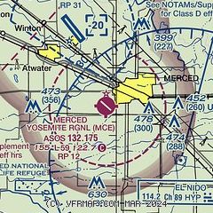
| Sectional chart |
|---|
|
| Airport distance calculator |
|---|
|
|
| Sunrise and sunset |
|---|
|
Times for 09-Jan-2026
| | Local
(UTC-8) | | Zulu
(UTC) |
|---|
| Morning civil twilight | | 06:49 | | 14:49 |
| Sunrise | | 07:17 | | 15:17 |
| Sunset | | 17:01 | | 01:01 |
| Evening civil twilight | | 17:30 | | 01:30 |
|
| Current date and time |
|---|
| Zulu (UTC) | 10-Jan-2026 01:34:08 |
|---|
| Local (UTC-8) | 09-Jan-2026 17:34:08 |
|---|
|
| METAR |
|---|
| KMCE | 100053Z AUTO 00000KT 10SM CLR 11/04 A3044 RMK AO2 SLP306 T01110039
|
KMER
6nm NW | 100055Z 00000KT 10SM CLR
|
|
| TAF |
|---|
| KMCE | 091720Z 0918/1018 VRB04KT P6SM SKC FM100700 VRB02KT 4SM BR SKC FM100900 11002KT 1 1/2SM BR SKC FM101300 12001KT 1/2SM FG SKC
|
KMER
6nm NW | 091720Z 0918/1018 VRB04KT P6SM SKC FM100700 VRB02KT 4SM BR SKC FM100900 11002KT 1 1/2SM BR SKC FM101300 12001KT 1/2SM FG SKC AMD NOT SKED
|
|
| NOTAMs |
|---|
NOTAMs are issued by the DoD/FAA and will open in a separate window not controlled by AirNav.
|
|

