FAA INFORMATION EFFECTIVE 16 APRIL 2026
Location
| FAA Identifier: | MLB |
| Lat/Long: | 28-06-09.9000N 080-38-42.9000W
28-06.165000N 080-38.715000W
28.1027500,-80.6452500
(estimated) |
| Elevation: | 33.3 ft. / 10.1 m (surveyed) |
| Variation: | 07W (2015) |
| From city: | 2 miles NW of MELBOURNE, FL |
| Time zone: | UTC -4 (UTC -5 during Standard Time) |
| Zip code: | 32935 |
Airport Operations
| Airport use: | Open to the public |
| Activation date: | 04/1940 |
| Control tower: | yes |
| ARTCC: | JACKSONVILLE CENTER |
| FSS: | SAINT PETERSBURG FLIGHT SERVICE STATION |
| NOTAMs facility: | MLB (NOTAM-D service available) |
| Attendance: | CONTINUOUS |
| Wind indicator: | lighted |
| Segmented circle: | yes |
| Lights: | WHEN ATCT CLSD ACTVT MALSR RWY 9R; REIL RWY 27L; PAPI RWY 9R & 27L; MIRL 5/23 & 9L/27R; HIRL RWY 9R/27L - CTAF. |
| Beacon: | white-green (lighted land airport)
Operates sunset to sunrise. |
| Fire and rescue: | ARFF index C |
| Airline operations: | INDEX D AVBL UPON REQ. |
| International operations: | US CUSTOMS USER FEE ARPT. |
Airport Communications
| CTAF: | 118.2 |
| UNICOM: | 122.95 |
| ATIS: | 132.55 |
| WX ASOS: | 132.55 (321-237-1257) |
| MELBOURNE GROUND: | 121.9 [0600-2400] |
| MELBOURNE TOWER: | 118.2 257.8 124.05 [0600-2400] |
| ORLANDO APPROACH: | 126.025 |
| ORLANDO DEPARTURE: | 126.025 |
| CLEARANCE DELIVERY: | 121.9 126.025 ;WHEN MLB TWR CLSD |
| BITHO STAR: | 128.375 |
| JOKRS STAR: | 134.05 |
| MELBOURNE DP: | 126.025 |
| PRICY STAR: | 134.05 |
| VFR ADZY: | 118.2 |
| WX AWOS-3PT at X59 (10 nm SE): | 119.525 |
| WX AWOS-3PT at COI (14 nm N): | 119.025 (321-986-8864) |
| WX AWOS-3PT at X26 (19 nm SE): | 118.125 (772-228-7020) |
Nearby radio navigation aids
| VOR radial/distance | | VOR name | | Freq | | Var |
|---|
| MLB at field | | MELBOURNE VOR/DME | | 115.85 | | 07W |
Airport Services
| Fuel available: | 100LL JET-A |
| Parking: | hangars and tiedowns |
| Airframe service: | MAJOR |
| Powerplant service: | MAJOR |
| Bottled oxygen: | NONE |
Runway Information
Runway 9R/27L
| Dimensions: | 10181 x 150 ft. / 3103 x 46 m
400 FT BLAST PAD BOTH RWY ENDS. |
| Surface: | asphalt/grooved, in excellent condition |
| Weight bearing capacity: | | Single wheel: | 120.0 | | Double wheel: | 233.0 | | Double tandem: | 397.0 | | Dual double tandem: | 928.0 |
|
| Runway edge lights: | high intensity |
| RUNWAY 9R | | RUNWAY 27L |
| Latitude: | 28-06.076883N | | 28-06.168152N |
| Longitude: | 080-39.668218W | | 080-37.776390W |
| Elevation: | 32.0 ft. | | 21.4 ft. |
| Traffic pattern: | left | | left |
| Runway heading: | 094 magnetic, 087 true | | 274 magnetic, 267 true |
| Displaced threshold: | no | | 699 ft. |
| Declared distances: | TORA:10181 TODA:10181 ASDA:10181 LDA:10181 | | TORA:10181 TODA:10181 ASDA:10181 LDA:9482 |
| Markings: | precision, in good condition | | precision, in good condition |
| Visual slope indicator: | 4-light PAPI on left (3.00 degrees glide path) | | 4-light PAPI on left (3.00 degrees glide path) |
| RVR equipment: | touchdown
RVR UNAVBL 0000-0600. | | rollout
RVR UNAVBL 0000-0600. |
| Approach lights: | MALSR: 1,400 foot medium intensity approach lighting system with runway alignment indicator lights | | |
| Runway end identifier lights: | | | yes |
| Centerline lights: | yes | | yes |
| Touchdown point: | yes, lighted | | yes, no lights |
| Instrument approach: | ILS | | |
| Obstructions: | none | | 36 ft. trees, 1640 ft. from runway, 420 ft. right of centerline, 40:1 slope to clear |
Runway 9L/27R
| Dimensions: | 6000 x 150 ft. / 1829 x 46 m |
| Surface: | asphalt/grooved, in excellent condition |
| Weight bearing capacity: | | Single wheel: | 49.0 | | Double wheel: | 78.0 | | Double tandem: | 139.0 |
|
| Runway edge lights: | medium intensity |
| RUNWAY 9L | | RUNWAY 27R |
| Latitude: | 28-06.324310N | | 28-06.378198N |
| Longitude: | 080-39.591550W | | 080-38.476640W |
| Elevation: | 30.5 ft. | | 26.0 ft. |
| Traffic pattern: | left | | left |
| Runway heading: | 094 magnetic, 087 true | | 274 magnetic, 267 true |
| Declared distances: | TORA:6000 TODA:6000 ASDA:6000 LDA:6000 | | TORA:6000 TODA:6000 ASDA:6000 LDA:6000 |
| Markings: | nonprecision, in good condition | | nonprecision, in good condition |
| Visual slope indicator: | 4-light PAPI on left (3.00 degrees glide path) | | 4-light PAPI on left (3.00 degrees glide path) |
| Touchdown point: | yes, no lights | | yes, no lights |
| Obstructions: | 26 ft. trees, 550 ft. from runway, 400 ft. left of centerline, 13:1 slope to clear
TREES 20 FT TALL, 200 FT BFR AER, 404 RIGHT OF CNTRLN. | | 46 ft. bldg, marked and lighted, 1880 ft. from runway, 450 ft. left of centerline, 36:1 slope to clear |
Runway 5/23
| Dimensions: | 3001 x 75 ft. / 915 x 23 m |
| Surface: | asphalt, in excellent condition |
| Weight bearing capacity: | | Single wheel: | 31.0 | | Double wheel: | 53.0 |
|
| Runway edge lights: | medium intensity |
| Operational restrictions: | RWY 05/23 NOT AVBL FOR PART 121/PART 380 OPS WITH SKED PAX CARRYING OPS MORE THAN 9 PAX SEATS AND NON-SKED PAX CARRYING OPS MORE THAN 30 PAX SEATS. |
| RUNWAY 5 | | RUNWAY 23 |
| Latitude: | 28-05.754223N | | 28-06.121710N |
| Longitude: | 080-38.243525W | | 080-37.869062W |
| Elevation: | 25.1 ft. | | 21.5 ft. |
| Traffic pattern: | left | | left |
| Runway heading: | 049 magnetic, 042 true | | 229 magnetic, 222 true |
| Declared distances: | TORA:3001 TODA:3001 ASDA:3001 LDA:3001 | | TORA:3001 TODA:3001 ASDA:3001 LDA:3001 |
| Markings: | basic, in good condition | | basic, in good condition |
| Visual slope indicator: | 2-light PAPI on left (3.00 degrees glide path) | | 2-light PAPI on left (3.00 degrees glide path) |
| Touchdown point: | yes, no lights | | yes, no lights |
| Obstructions: | 41 ft. trees, 1240 ft. from runway, 135 ft. right of centerline, 25:1 slope to clear | | 45 ft. hangar, lighted, 1370 ft. from runway, 65 ft. right of centerline, 26:1 slope to clear |
Airport Ownership and Management from official FAA records
| Ownership: | Publicly-owned |
| Owner: | CITY OF MELBOURNE
1 AIR TERMINAL PKWY/SUITE 220
MELBOURNE, FL 32901
Phone 321-723-6227 |
| Manager: | GREG DONOVAN
1 AIRPORT TERMINAL PKWY, SUITE 220
MELBOURNE, FL 32901
Phone 321-723-6227 |
Additional Remarks
| A39-09R/27L | PCR VALUE: 580/F/B/X/T |
| A39-09L/27R | PCR VALUE: 170/F/B/X/T |
| A39-05/23 | PCR VALUE: 100/F/B/X/T |
| - | TGL NA AFT 2100 OR 2 HR AFT SS; WHICHEVER IS LATER. |
| - | RSTRD: MIL AIRCREW USE OF NORTHROP/GRUMMAN RAMP PPR - GRUMMAN OPS DSN 854-5245 EXTN 5522, C407-5522; PRIOR TO ARR - GRUMMAN OPS 123.2. |
| - | UNCONTROLLED AREA TWY V WEST OF RWY 5; TWY C NORTH OF TWY K; TWY S NORTH OF S1; TWY H & G. |
| - | SFC COND NOT RPRTD 2300-0600. |
| - | BIRD ACT ON & INVOF ARPT. |
| - | GA ACFT PRKG ON TRML APN PROHIBITED WITHOUT PPR FM ARPT MGMT. |
| - | 24 HR ADVN NOTICE OR IMT REPORTING UPON LDG FOR ACFT EQUIPPED WITH WEATHER MODIFICATION OR GEOENGINEERING EQUIP CTC ARPT OPS 321-288-1578. |
Instrument Procedures
NOTE: All procedures below are presented as PDF files. If you need a reader for these files, you should download the free Adobe Reader.NOT FOR NAVIGATION. Please procure official charts for flight.
FAA instrument procedures published for use from 16 April 2026 at 0901Z to 14 May 2026 at 0900Z.
STARs - Standard Terminal Arrivals |
|---|
| BITHO SEVEN | |
download (215KB) |
| JOKRS FOUR (RNAV) **NEW** | |
2 pages:
[1] [2] (332KB) |
| PRICY FIVE (RNAV) **NEW** | |
2 pages:
[1] [2] (404KB) |
| PRICY FIVE (RNAV), CONT.2 **NEW** | |
download (152KB) |
IAPs - Instrument Approach Procedures |
|---|
| ILS OR LOC RWY 09R | |
download (244KB) |
| RNAV (GPS) RWY 09L | |
download (250KB) |
| RNAV (GPS) RWY 09R | |
download (248KB) |
| RNAV (GPS) RWY 27L | |
download (230KB) |
| RNAV (GPS) RWY 27R | |
download (234KB) |
| LOC BC RWY 27L | |
download (240KB) |
| VOR RWY 09R | |
download (231KB) |
| VOR RWY 27L | |
download (182KB) |
| NOTE: Special Alternate Minimums apply | |
download (124KB) |
Departure Procedures |
|---|
| MELBOURNE EIGHT | |
download (176KB) |
| NOTE: Special Take-Off Minimums/Departure Procedures apply | |
download (400KB) |
Other nearby airports with instrument procedures:
KCOF - Patrick Space Force Base Airport (8 nm N)
X59 - Valkaria Airport (10 nm SE)
KCOI - Merritt Island Airport (14 nm N)
X26 - Sebastian Municipal Airport (19 nm SE)
KXMR - Cape Canaveral Space Force Station Skid Strip Airport (22 nm N)
|
|

Road maps at:
MapQuest
Bing
Google
| Aerial photo |
|---|
WARNING: Photo may not be current or correct
 Photo by Liz Waymire
Photo taken 02-Dec-2008
Photo by Liz Waymire
Photo taken 02-Dec-2008
Do you have a better or more recent aerial photo of Melbourne Orlando International Airport that you would like to share? If so, please send us your photo.
|
| Sectional chart |
|---|
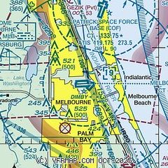
|
CAUTION: Diagram may not be current
 Download PDF
of official airport diagram from the FAA
| Airport distance calculator |
|---|
|
|
| Sunrise and sunset |
|---|
|
Times for 18-Apr-2026
| | Local
(UTC-4) | | Zulu
(UTC) |
|---|
| Morning civil twilight | | 06:31 | | 10:31 |
| Sunrise | | 06:56 | | 10:56 |
| Sunset | | 19:48 | | 23:48 |
| Evening civil twilight | | 20:13 | | 00:13 |
|
| Current date and time |
|---|
| Zulu (UTC) | 18-Apr-2026 23:50:53 |
|---|
| Local (UTC-4) | 18-Apr-2026 19:50:53 |
|---|
|
| METAR |
|---|
| KMLB | 182253Z 11009G17KT 10SM CLR 26/19 A2997 RMK AO2 SLP147 T02610194
|
KCOF
8nm NE | 182255Z AUTO 11009KT 10SM CLR 27/21 A2995 RMK AO2 SLP147 T02660206 $
|
KX26
19nm SE | 182335Z AUTO 11006KT 10SM CLR 25/21 A2998 RMK AO2
|
|
| TAF |
|---|
| KMLB | 181722Z 1818/1918 10010KT P6SM FEW030 FM190100 VRB05KT P6SM FEW060 SCT250 FM191300 28006KT P6SM SCT250
|
|
| NOTAMs |
|---|
NOTAMs are issued by the DoD/FAA and will open in a separate window not controlled by AirNav.
|
|


