FAA INFORMATION EFFECTIVE 16 APRIL 2026
Location
| FAA Identifier: | XMR |
| Lat/Long: | 28-28-03.3170N 080-33-59.8110W
28-28.055283N 080-33.996850W
28.4675881,-80.5666142
(estimated) |
| Elevation: | 9.6 ft. / 2.9 m (surveyed) |
| Variation: | 07W (2020) |
| From city: | 7 miles NE of COCOA BEACH, FL |
| Time zone: | UTC -4 (UTC -5 during Standard Time) |
| Zip code: | 32920 |
Airport Operations
| Airport use: | Private use, PPR FM ROS, CCAFS, FL V467-5941. |
| Control tower: | yes |
| ARTCC: | JACKSONVILLE CENTER |
| FSS: | SAINT PETERSBURG FLIGHT SERVICE STATION
FSS-ST. PETERSBURG (PIE) - NOTAM - XMR. |
| NOTAMs facility: | PIE (NOTAM-D service available) |
| Attendance: | MON-FRI IRREG
CLSD SAT, SUN AND HOLIDAY. SEE FLIP AP/1 SUPPLEMENTARY INFO. |
| Pattern altitude: | 1100 FT RECTANGULAR, 1600 FT OVHD, 600 FT HEL. |
| Wind indicator: | yes |
| Segmented circle: | no |
| Beacon: | white-green (lighted land airport) |
Airport Communications
| WX ASOS: | 119.325 |
| CAPE TOWER: | 118.625 143.15 239.05 126.2 [NO SPECIFIC WORK HOURS MON-FRI; CLSD SAT, SUN & HOLIDAYS.] |
| ORLANDO APPROACH: | 134.95 |
| ORLANDO DEPARTURE: | 134.95 |
| BITHO STAR: | 128.375 |
| PMSV METRO: | 225.05 |
| PTD: | 139.3 372.2 |
| WX AWOS-3PT at COI (10 nm SW): | 119.025 (321-986-8864) |
| WX AWOS-3PT at TIX (13 nm W): | 120.625 (321-567-6090) |
| WX AWOS-3PT at X21 (17 nm NW): | 119.725 (321-385-0383) |
- ON REQ 0730-1600LCL OTHER TIMES IF NOTICE RECVD PRIOR TO 1400.
Nearby radio navigation aids
| VOR radial/distance | | VOR name | | Freq | | Var |
|---|
| MLBr016/22.0 | | MELBOURNE VOR/DME | | 115.85 | | 07W |
Airport Services
| Airframe service: | NONE |
| Powerplant service: | NONE |
| Bottled oxygen: | NONE |
| Bulk oxygen: | NONE |
Runway Information
Runway 13/31
| Dimensions: | 9999 x 200 ft. / 3048 x 61 m |
| Surface: | asphalt/grooved |
| Weight bearing capacity: | | PCN 37 /F/A/W/T | | Dual double tandem: | ST 175, SBTT 538, TRT 522, TDT 890 |
|
| Runway edge lights: | high intensity |
| RUNWAY 13 | | RUNWAY 31 |
| Latitude: | 28-28.560833N | | 28-27.549667N |
| Longitude: | 080-34.734667W | | 080-33.259167W |
| Elevation: | 9.4 ft. | | 9.2 ft. |
| Traffic pattern: | left | | left |
| Runway heading: | 135 magnetic, 128 true | | 315 magnetic, 308 true |
| Markings: | nonprecision, in good condition | | nonprecision, in good condition |
| Visual slope indicator: | 4-light PAPI on left (3.00 degrees glide path) | | 4-light PAPI on left (3.00 degrees glide path) |
| Approach lights: | | | SALS |
| Runway end identifier lights: | no | | no |
| Touchdown point: | yes, no lights | | yes, no lights |
Airport Ownership and Management from official FAA records
| Ownership: | U.S. Air Force |
| Owner: | USAF
PATRICK AFB
COCOA BEACH, FL 32925
Phone V467-5941 |
| Manager: | CHIEF OF AFLD MANAGEMENT
PATRICK AFB
COCOA BEACH, FL 32925
Phone 321-853-4242
PATRICK AFB OPS # 321-494-2222 |
Additional Remarks
| - | SERVICE LGT: RWY 31 APCH LGT NSTD SALS, 1000'. |
| - | TRAN ALERT: CHIP DETECTION INSP RQRD BY F16'S NOT AVBL. |
| - | CSTMS AVBL: PN RQR. |
| - | MISC: OBSN AUTOMATED, FMQ-19 OBSN WX EQUIP IN USE H24. WX OBSN/FCST AVBL H24 VIA FONE DSN 467-8484, C321-853-8484. LTD PRK. NO CLASSIFIED MATERIALS STOR AVBL. |
| - | JASU: 1(AM32A-60A) 1(A/M32A-86D). |
| - | MISC: AM OPS DSN 467-4241, COMM (321) 853-4241, FAX COMM (321) 853-1521. |
| - | RY 13/31 DOES NOT HAVE PAVED OVERRUNS. |
| - | RSTD: PPR. PPR VALID +/- 30 MIN PRIOR/AFTER ETA, CHANGES MUST BE COORDINATED. TWR MANNED BASED ON PPR. CTC 45 RANS/DOS, CCAFS, FL DSN 467-5941, C321-853-5941 FOR PPR. |
| - | EARLY/LATE ARR/DEP MUST BE RECOORDINATED. |
| - | CAUTION: NVD OPS MAY BE IN PROGRESS SS-SR. CHECK LCL NOTAMS FOR CURRENT OPS. |
| - | PMSV METRO: CALL CAPE METRO; TRML WX FCST NOT ISSUED FOR KXMR, SEE KCOF. |
| - | RWY - FIRST 1,000 FT RWY 13 AND FIRST 1,000 FT RWY 31 CONC. MIDDLE 7,999' FT RWY 13/31 POROUS FRICTION SFC. 300' X 300' STRESSED TURNAROUND EACH END. RWY GROOVED. |
| - | RSTD: CREW TRANSPORT/CARGO ONLOAD/OFFLOAD SUPPORT LTD TO 1400-2000Z++ MON-FRI. CTC: DSN 854-5631, C321-494-5631 WITH REQUESTED REQUIREMENTS. |
| - | TRAN ALERT: MANNED BASED ON PPR. SVC AVBL 1100-0400Z MON-FRI, CLSD SAT, SUN AND HOL. OT RQR 10 DAYS ADVANCE NOTICE. CTC DSN 854-5425/26, C321-494-5425/26 WITH REQ FOR SVC. |
| - | FUEL: J8 1200 - 2200Z++MON-FRI, OTR TIMES RQR 5 DAYS ADVN NOTICE. DUE TO LTD MANNING, AIRCREW ASSISTANCE IS RQRD WITH RFL OPS. |
| - | FUEL: A++. |
| - | FLUID - LOX AVBL WITH 2 DAY PN. |
| - | CAUTION: USAF ARFF SET 3. 3 ARFF VEHICLE WITH 5000 GALS OF AGENT. |
| - | FOR CD OR TO CNL IFR WHEN ATCT CLSD, CTC ORLANDO APCH AT 407-852-7500. |
| - | 50 FT WINGTIP CLNC BTN LRG FRAME ACFT NOT AVBL BTN PRKG SPOT 2 AND 3. MNM WING-TIP SEPN RDCD TO 30 FT. MAJCOM WAIVER ON FILE. |
| - | RSTD: ALL ACFT WILL CTC APP BEFORE PROCEEDING TO CAPE CANAVERAL. LDG AND TKOF NOT AUTH UNLESS CAPE TWR IS OPR. |
| - | RSTD: OFFL BUS OR HI PRIORITY MSN ACFT CTC 1 ROPS/DOS, CCSFS, FL, DSN 467-5941, C321-853-5941 FOR PPR. PPR FOR OPR 1230-2100Z++, MON-FRI RQR 24 HR PN, PPR OT RQR 5 DAY PN. SKID STRIP OPR HR ARE DETERMINED BY PPR NR FOR SPECIFIED OPR. |
| - | RSTD: NO ARR OR DEP WITHIN 1 HR OF CAPE CANAVERAL LAUNCH OPR. LDG AND TKOF NOT AUZD UNLESS CAPE TWR IS OPR. ALL ACFT WILL CTC APP BEFORE PROCEEDING TO CAPE CANAVERAL. FLT IS RSTD TO 1000' ABV AND WITHIN A HORIZONTAL RAD OF 2000' FR ANY SPACE LAUNCH COMPLEX. |
| - | RSTD: IF OPR NECESSITY RQR FLT CLOSER THAN THESE RSTD, COORD WITH THE CUSTODIAN OF THE AFFECTED COMPLEX SHALL BE ACCOMPLISHED NO LATER THAN 24 HR PRIOR TO FLT. |
| - | CAUTION: MANY OBST IN VCNTY OF RWY. BIRD HAZ. USE EXTREME CAUTION FOR EXTENSIVE UAS OPS IN VCNTY. |
Instrument Procedures
NOTE: All procedures below are presented as PDF files. If you need a reader for these files, you should download the free Adobe Reader.NOT FOR NAVIGATION. Please procure official charts for flight.
FAA instrument procedures published for use from 16 April 2026 at 0901Z to 14 May 2026 at 0900Z.
STARs - Standard Terminal Arrivals |
|---|
| BITHO SEVEN | |
download (215KB) |
IAPs - Instrument Approach Procedures |
|---|
| RNAV (GPS) RWY 13 | |
download (123KB) |
| RNAV (GPS) RWY 31 | |
download (116KB) |
| TACAN-A | |
download (107KB) |
| NOTE: Special Take-Off Minimums/Departure Procedures apply | |
download (407KB) |
Other nearby airports with instrument procedures:
KCOI - Merritt Island Airport (10 nm SW)
KTTS - Space Florida Launch and Landing Facility Airport (11 nm NW)
KTIX - Space Coast Regional Airport (13 nm W)
KCOF - Patrick Space Force Base Airport (14 nm S)
X21 - Arthur Dunn Air Park (17 nm NW)
|
|

Road maps at:
MapQuest
Bing
Google
| Aerial photo |
|---|

|
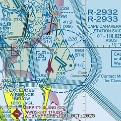
| Sectional chart |
|---|
|
 Download PDF
of official airport diagram from the FAA
| Airport distance calculator |
|---|
|
|
| Sunrise and sunset |
|---|
|
Times for 10-May-2026
| | Local
(UTC-4) | | Zulu
(UTC) |
|---|
| Morning civil twilight | | 06:10 | | 10:10 |
| Sunrise | | 06:36 | | 10:36 |
| Sunset | | 20:02 | | 00:02 |
| Evening civil twilight | | 20:27 | | 00:27 |
|
| Current date and time |
|---|
| Zulu (UTC) | 10-May-2026 14:18:07 |
|---|
| Local (UTC-4) | 10-May-2026 10:18:07 |
|---|
|
| METAR |
|---|
KXMR
2nm E | 101355Z AUTO 22006KT 9SM SCT070 29/24 A2997 RMK AO2 SLP152 T02860235 $
|
KTIX
12nm W | 101347Z 21008KT 7SM BKN070 29/24 A3002
|
KTTS
12nm NW | 101355Z AUTO 21007KT 10SM BKN070 27/23 A2998 RMK AO2 SLP156 T02740234 $
|
KCOF
15nm S | 101355Z AUTO 29003KT 10SM CLR 27/24 A2998 RMK AO2 SLP157 T02720240 $
|
|
| TAF |
|---|
KTIX
12nm W | 101158Z 1012/1112 VRB03KT 6SM BR BKN060 OVC250 TEMPO 1012/1013 4SM BR FM101400 24007KT P6SM SCT050 BKN170 FM101800 06009KT P6SM VCTS SCT050CB SCT150 TEMPO 1020/1023 3SM TSRA FM110100 VRB03KT P6SM FEW050 SCT180
|
|
| NOTAMs |
|---|
NOTAMs are issued by the DoD/FAA and will open in a separate window not controlled by AirNav.
|
|


